

How much snow fell in your area? Find out here.
NEW YORK - A coastal storm brought heavy rain, strong winds and snow to parts of the tri-state area Thursday into Friday and even Saturday. While areas in and around New York City saw mostly rain, several inches of snow were reported in other parts of the state, as well as areas of New Jersey.
Check out the snow totals in inches for your area below from the National Weather Service:
Albany County
Knox: 15.0
Broome County
Binghamton: 9.4
Whitney Point: 8.8
Lisle: 7.5
Sanitaria Spgs: 7.5
Vestal Center: 6.0
Endicott: 6.0
Johnson City: 5.5
NW Endwell: 5.0
Chenango County
Norwich: 13.0
Holmesville: 12.0
Greene: 7.5
Guilford: 6.0
Cortland County
Virgil: 10.4
Homer: 7.5
Marathon: 6.3
Delaware County
Roxbury: 6.0
Meridale: 6.0
Erie County
Eden: 9.1
Hamburg: 8.9
Lake View: 8.6
Fulton County
Amsterdam: 8.0
Perth: 4.5
Greene County
Greenville Center: 13.5
East Jewett: 13.0
Hamilton County
Piseco: 20
Inlet: 13
Madison County
Oneida: 5.5
Chittenango: 4.8
Montgomery County
Glen: 8.0
Amsterdam: 6.5
Oneida County
Paris: 14.0
Forestport: 11.5
Sauquoit: 10.8
Clayville: 9.0
Barneveld: 7.0
Boonville: 7.0
New Hartford: 6.5
Clinton: 6.5
Holland Patent: 6.5
Whitesboro: 6.3
Utica: 5.0
Onondaga County
Fabius: 9.9
Jamesville: 9.2
Syracuse: 6.0
Onondaga: 5.0
Otsego County
Cherry Valley: 14.0
East Springfield: 14.0
Worcester: 12.0
Richfield Springs: 9.0
Cooperstown: 8.5
Edmeston: 8.5
Morris: 7.0
Oneonta: 7.0
Schenevus: 7.0
Emmons: 7.0
South New Berlin: 6.0
Laurens: 5.8
Milford: 4.0
Rensselaer County
Averill Park: 6.3
Troy: 4.8
Rensselaer: 4.5
Saratoga County
Lake Desolation: 12.0
Schenectady County
Delanson: 15.0
Duanesburg: 10.0
Schoharie County
Middleburgh: 20.0
Schoharie: 15.0
Richmondville: 13.0
Jefferson: 12.5
Charlotteville: 11.8
Sullivan County
Kiamesha: 9.8
Grahamsville: 7.3
Mountain Dale: 4.0
Tioga County
Lockwood: 7.0
Candor: 7.0
Waverly: 5.2
Tioga Terrace: 5.0
Owego: 5.0
Berkshire: 4.5
Washington County
Hartford: 10.0
Granville: 10.0
Hebron: 9.0
Download the FREE Fox 5 NY weather app and always stay updated on storms.
Apple App Store: https://apple.co/2GrlPnz Google Play Store: http://bit.ly/2IPSlTd
Could New York City have a White Christmas this year?

Weather forecast
It was all sorts of ick today, but it'll get better this weekend, although not a whole lot warmer. FOX 5 NY's Nick Gregory has your weather forecast.
Now, onto Christmas.
On average, New York City receives 4.8 inches of snow in December.
Statistically, Central Park has only an 11% chance each year of having that happen. Brooklyn's chances are around 10%. Queens is at a 12% probability.
Parts of upstate New York have greater chances of seeing a White Christmas so just because it may not happen in Manhattan — literally based on a measurement in Central Park — doesn't mean it couldn't happen elsewhere in the metropolitan area.
Here is a U.S. map from NOAA showing the historic probability of a White Christmas based on data from 1991 to 2020. (To view a higher resolution version, click here.)
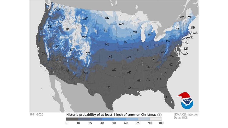
The historic probability of a White Christmas; dataset: 1991–2020. (NOAA Image)
When Was the Last White Christmas in NYC?
The last White Christmas in New York City was in 2009 when 2 inches of snow was recorded.
You then have to go back to 2002 when 5 inches of snow was recorded in Central Park.
Other prior White Christmases were in 1995, when cold temperatures kept snow on the ground from an earlier storm; 1983; and 1966.
The record Christmas Day snowfall for Central Park was 7 inches in 1909. The record snow depth on Christmas Day in Central Park was 8 inches in 1912.
Do you remember experiencing a White Christmas?

Weather Latitudes
Why do cities with the same latitude had such different climates? For instance, why is New York so much snowier than Madrid?
What about New Jersey?
According to the Old Farmer's Almanac, in the Northeast, snow showers are possible in the days leading up to Christmas, with temperatures trending colder.
In fact, they predict between Dec. 23-26, a mix of rain and snow is possible. Conditions will be chilly. Winter temperatures will be below normal, while precipitation and snowfall will be above normal.
Here is a U.S. map from NOAA showing the historic probability of a White Christmas based on data from 1991 to 2020. (To view a higher resolution version, click here.)
The historic probability of a White Christmas; dataset: 1991–2020. (NOAA Image)
What Is the Definition of White Christmas?
In the United States, the National Weather Service defines a "White Christmas" as an inch or more of snow observed on the ground on Christmas morning. So a dusting of snow remaining from earlier snowfall doesn't count. Yet an inch or more still on the ground on Dec. 25 from a prior storm meets the White Christmas standard.
Other countries and traditions may have different definitions. For example, some cultures consider snowfall on Christmas Eve to qualify as a White Christmas.
Weather Resources
Follow the FOX 5 Weather Team on Twitter
- Nick Gregory @NickGregoryFox5
- Mike Woods @MikeWoodsFox5
- Audrey Puente @AudreyPuente
- Raegan Medgie @RaeganMedgie
—
Record Snow in NYC
The record one-day snowfall for New York City is 26.9 inches, which fell during a storm in February 2006. A January 2016 storm dumped 26.8 inches in Central Park in one day.
Nick Gregory is the chief meteorologist for Fox 5 News. Arun Kristian Das is a senior digital content creator for Fox5NY.com.