

Ida could bring heavy rains, flooding to New York City region

Weather Forecast
Meteorologist Mike Woods says bring your umbrella. Light rain will continue to fall through the morning. Heavier rain is on its way.
NEW YORK - After hitting the United States as a Category 4 hurricane, Ida, now a tropical depression, is pushing north and threatens to bring heavy rain and possible flooding to the New York City region.
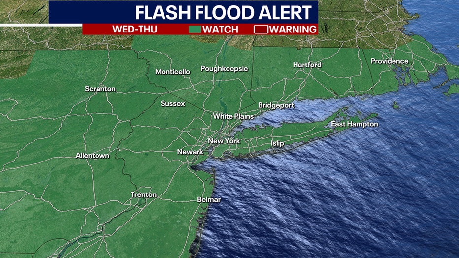
A Flash Flood Watch is now in effect for the tri-state area, including New Jersey, New York City, Long Island, areas north of NYC, and much of Connecticut for Wednesday morning through Thursday night due to heavy rain associated with the remnants of Ida.
The National Weather Service warns that moderate to major flooding is possible along some main stem rivers. Roads and structures near these rivers could also be flooded. The timing of the storm is starting Tuesday night and possibly lasting into Thursday afternoon.
How much rain are we getting from Ida?
Here are the keys to the storm for the New York City area:
- Storm rainfall totals are expected to be 3 to 5 inches with locally higher amounts possible.
- Rainfall rates could be 1 to 2 inches an hour at times.
- The timing is Wednesday afternoon into Thursday afternoon.
A severe threat of severe thunderstorms is possible, mainly over southern New Jersey. Wind gusts could bring down trees due to the saturated ground leading to localized power outages. The best bet for that happening is Wednesday afternoon and Wednesday night.
Get breaking news alerts in the free FOX5NY News app! | Sign up for FOX 5 email newsletters
The risk for flash flooding across most of New Jersey was classified as moderate through Thursday.
A Gale Watch was posted for the Jersey shore, New York City, and the southern coast of Long Island.
"Widespread rainfall of 2 to 5 inches, with locally higher amounts possible, from Tuesday night through Thursday across the region, with the highest amounts from the I-95 corridor north and west," the National Weather Service office in Mount Holly, New Jersey, said in an advisory. "Significant flooding and flash flooding is probable Wednesday and Wednesday night, especially given that the ground is saturated from recent heavy rain events."
The forecast is not welcome to some areas of New Jersey that had to deal with flooding from the remnants of Hurricane Henri less than 2 weeks ago.
According to the National Weather Service, as much as 4-8 inches of rain fell across much of the center of the state, with small pockets receiving 7-10 inches.
Middlesex County was especially hard hit. The small town of Jamesburg had nearly 10 inches of rain, causing widespread flooding and rescue crews using boats to evacuate people.
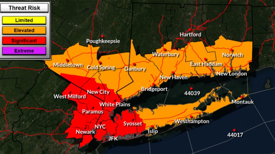
The storm was expected to also cause a potential for flooding in New York City. On Monday afternoon the threat for excessive rainfall was raised to "significant" by the National Weather Service for areas including West Milford, Paramus, and Newark in New Jersey along with all of New York City, northern suburbs including White Plains and New City, and Western Long Island, including Syosset.
"Deep tropical moisture will interact with a nearly stationary frontal boundary across the Middle Atlantic and Northeast to produce heavy rainfall late Wednesday through Thursday morning. The rainfall should begin to taper off Thursday afternoon," the National Weather Service office in Upton, New York, said in an advisory. "A widespread 3 to 5 inches of rain is forecast with locally higher amounts possible. This rainfall combined with wet antecedent conditions may lead to flash flooding. Flooding of fast responding rivers and streams is possible, and flooding of main stem rivers cannot be ruled out."

Henri hits NYC causing flooding, damage
Rain continued to fall across New York City Monday extending the danger from flooding that already wreaked havoc in the region.
Download the FREE Fox 5 NY weather app and always stay updated on storms.
Apple App Store: https://apple.co/2GrlPnz Google Play Store: http://bit.ly/2IPSlTd