

Winter Storm Warning: NYC, NJ, LI could see 10 inches of snow Tuesday
NEW YORK CITY - Click here for latest winter storm warning, snow forecast for NYC.

A Winter Storm Warning has been issued for NYC, Long Island, and northern NJ as a powerful snowstorm is expected to dump nearly 10 inches of snow on the city. The warning takes effect at 1 a.m.
The storm is expected to drop heavy, wet snow all across the tri-state area, with the National Weather Service saying that 6 to 10 inches of snowfall is likely in the NYC metro area, with a reasonable worst-case scenario of 10-12 inches.
In response, NYC Emergency Management has issued a travel advisory from Monday night through Tuesday. Schools have announced closings throughout the region, including New York City Public Schools, which will move to remote learning on Tuesday.

Winter storm could drop 10 inches of snow on NYC
A winter storm could bring as much as 10 inches of snow to New York City on Tuesday, in the first major winter storm in over two years.
JUMP TO: WARNINGS l TIMELINE l TOTALS l TRACK l SCHOOLS l LIVE RADAR
"We're strongly encouraging New Yorkers, if you don't have to go out, stay home," Mayor Eric Adams said.
While the exact track of the storm remains unknown, one thing is for certain: Tuesday morning's commute will be very messy and difficult.
Here's everything you need to know about Tuesday's winter storm:
Impacts: Winter watches, warnings
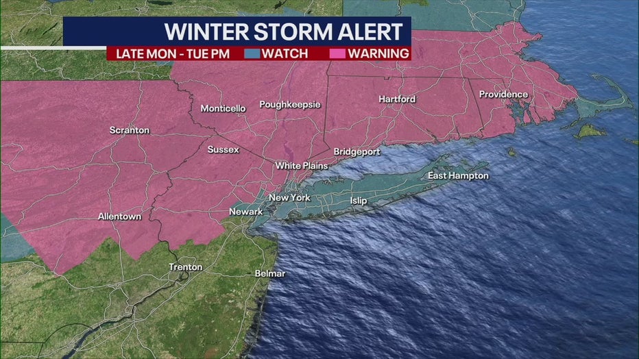
Winter storm warnings and watches for Tri-State area.
- Winter storm warning: 1 a.m. Tuesday through 6 p.m. Tuesday for interior NE New Jersey, Lower Hudson Valley, and southern Connecticut.
- Winter storm watch: 4 a.m. Tuesday through 6 p.m. Tuesday for New York City, Long Island and parts of NE New Jersey.
Timeline: When will snow start in NYC?
Monday evening
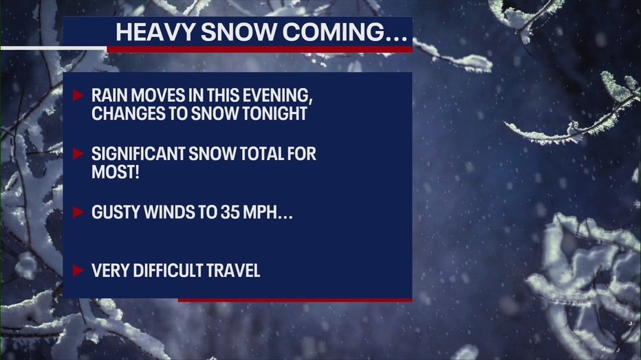
Temperatures will be warm enough on Monday that the storm will likely begin as rain across the area.
But as the system continues to advance to the northeast and eventually move off the East Coast, it will begin to pull in the colder air from the north and Canada, which will change the precipitation over to snow.
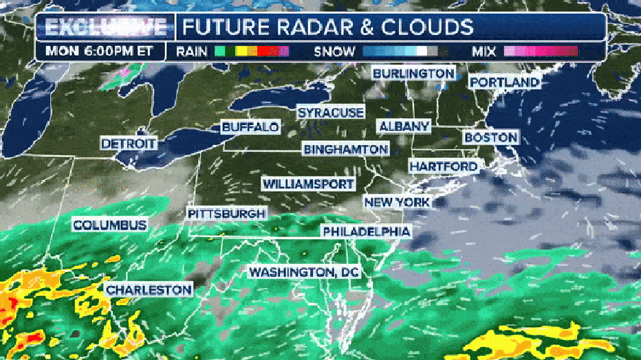
The exclusive FOX Weather future radar and clouds showing the potential nor'easter this week. (FOX Weather)
"The storm itself, and the placement and the movement and the track is still a bit of a question as far as how it moves," FOX Weather Meteorologist Craig Herrera said.
Tuesday morning
By the pre-dawn hours of Tuesday, widespread snow is expected across portions of New York, making the morning commute for people heading to work quite tricky and dangerous.
"It really dumps out the snow during the commute for you tomorrow, so it's the Tuesday morning, trying to get around thing that's going to be difficult, if not impossible. This heavy snow does come together," FOX 5 NY's Mike Woods said.
What to know for Tuesday's storm.
Snow could fall at rates of 1-3 inches per hour.
Other schools across the region will likely be closed as the potential nor’easter begins to ramp up.
Tuesday afternoon
Snow will continue throughout the day Tuesday and will likely begin to pull away from the region during the evening commute.
Totals: How much snow will NYC see?
NYC and areas on Long Island could see 6 to 10+ inches, with locally higher amounts possible.
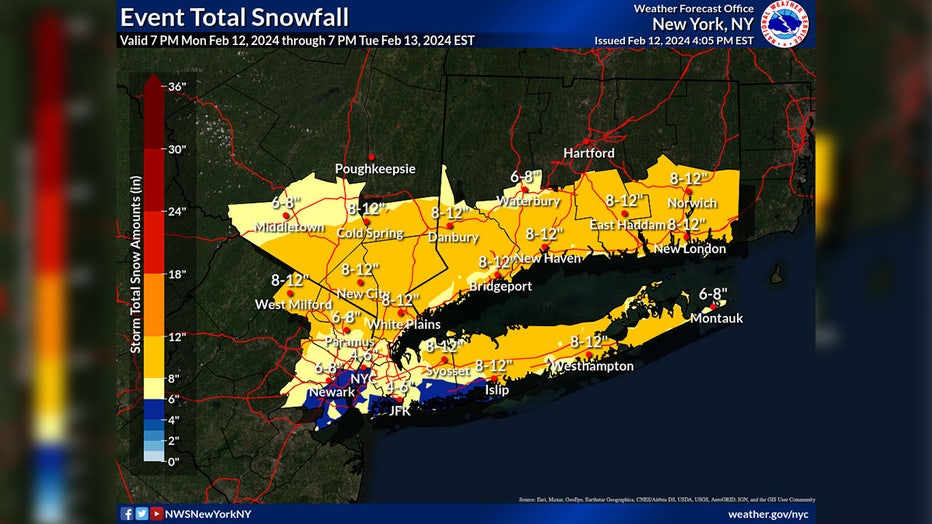
Credit: National Weather Service
Snowfall rates of 1 to 2+ inches per hour are possible.
"One way or another, if it's not snow, it's going to be rain, which will be heavy at times," Woods said. "Windy at the same time."
How much snow will the rest of the Tri-State area see?
Interior NE New Jersey, interior Lower Hudson Valley and interior southern Connecticut could also see 6-10+ inches, with locally higher amounts, especially north I-84 late Monday night into Tuesday.
Portions of NE New Jersey, southern Westchester, coastal Connecticut could see similar amounts.
Parts of south and central NJ could see 3 to 5 inches.
Questions: How does the track direction impact totals?
- A more northern track with the low pressure would reduce snowfall totals in the warning area, according to the National Weather Service.
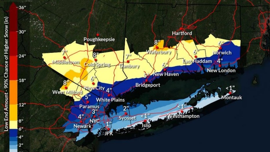
Snow amounts could be this low if the storm track ends up further north/warmer. (NWS)
- A more southern track with the low pressure would lower snowfall totals inland, but would likely increase snowfall totals down to the coast across NYC metro and Long Island, the NWS said.
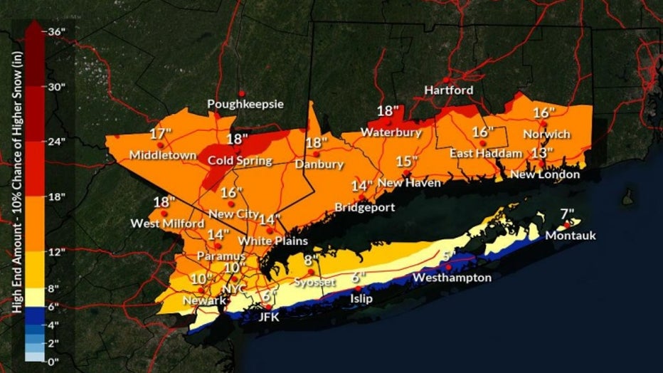
Snow amounts could be close to these levels if storm track is further south/colder or with heavier snow banding over inland areas. (NWS)
- Location of heavy snow banding will be refined as the event unfolds.
Closings: Is there school tomorrow in NYC?
New York City public schools will move to remote learning on Tuesday due to the incoming snow storm, Mayor Eric Adams tweeted.
Mid-winter weather outlook: ‘6 more weeks’ of winter
New York City's Central Park has recorded a measly 2.3 inches of snow this winter, but FOX 5 NY’s Nick Gregory said the area has the potential for at least another 15 inches, according to his mid-winter forecast.
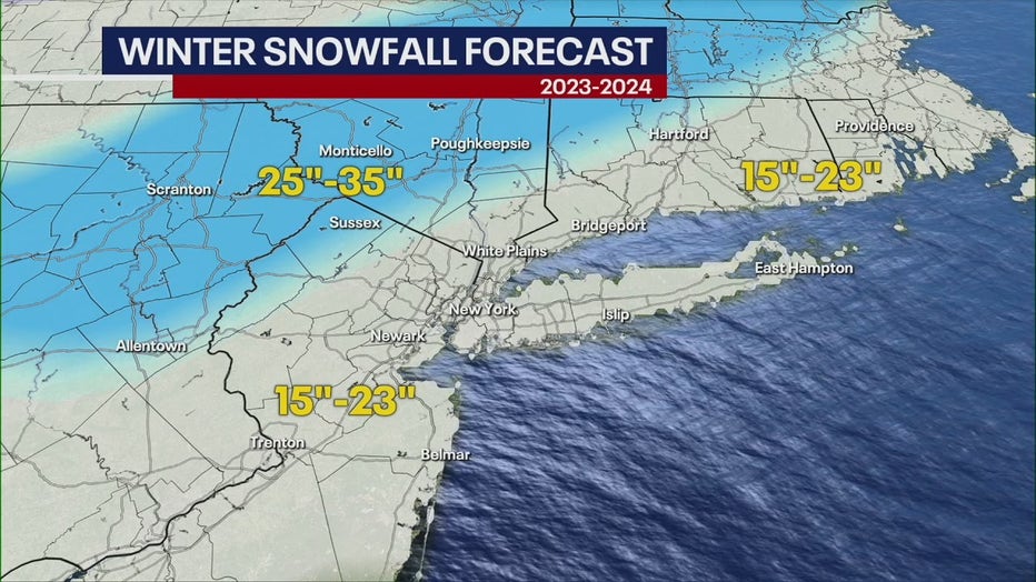
Only one or two decent storms will help us reach this projected total, and Nick forecasts that February will provide the perfect conditions for winter storm development.
The U.S. is experiencing a strong El Niño, meaning the Tri-State is more likely to see warmer-than-average temperatures and wetter-than-average precipitation.
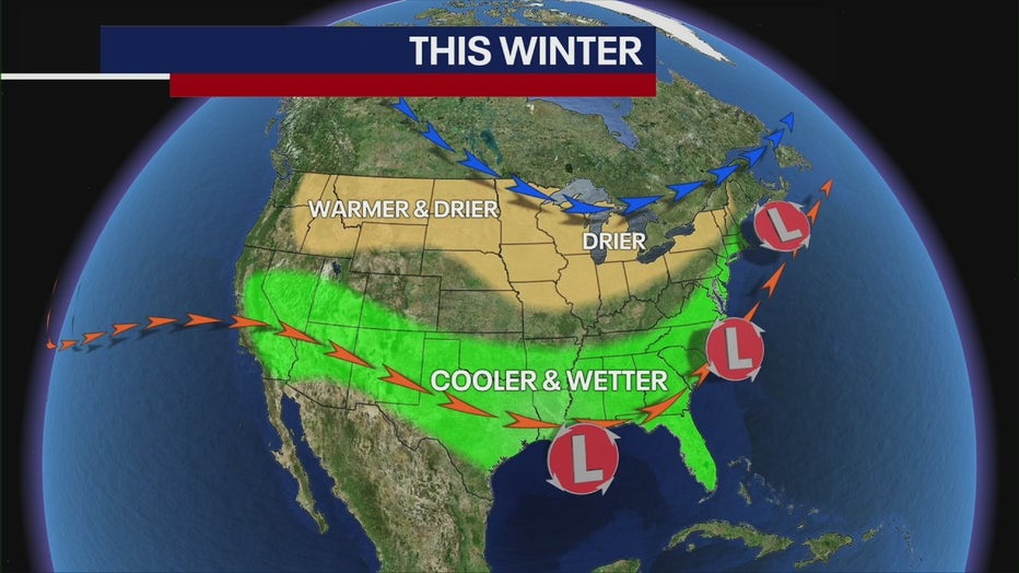
As we move forward, strong El Niño conditions will continue, meaning February will feature the same type of weather we've seen: above-average temperatures and borderline rain-snow events.
"I think winter will be prolonged here, and I do think that we'll probably have a good surge of cold weather coming in the middle part of February, [creating the potential for a snow storm or two," Nick said.
Steven Yablonski, with FOX Weather, helped contribute to this report.