

NYC snow storm weather forecast: Heavy snowfall slamming area

Snow storm begins in NYC
FOX 5 NY's Mike Woods shows us where the storm is headed as NYC braces for heavy snow.
NEW YORK - A major winter storm has arrived in NYC and is starting to dump very heavy snow onto the Tri-State, falling as fast as 2 inches per hour.
JUMP TO: LIVE RADAR | SCHOOL CLOSINGS l TOTALS SO FAR
Metro and suburban NY, NJ and CT will likely see 6 to 8+ inches of snow Tuesday, FOX 5 NY's Mike Woods now predicts, a dramatic meteorological plot twist following Central Park's 700-day snow drought.
Featured

NYC snow storm: When will the snow stop today?
A major winter storm is intensifying across NYC, as a heavy snow band is currently dumping 1-2+ inches per hour across parts of NY, NJ and CT.
A Winter Storm Warning covers the entire region -- stretching from Long Island, through northern NJ and up the Hudson Valley – as officials warn drivers to stay off the roads, anticipating a dangerous Tuesday morning commute. Flights are canceling, schools are closing and communities are bracing for power outages.
Here's what you need to know about the storm, including an hour-by-hour weather forecast, expected snow totals and the worst-case scenario.
Weather forecast timeline: Monday through Tuesday
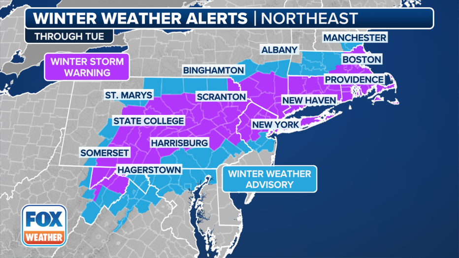
Winter weather alerts in effect in the Northeast and New England. (FOX Weather)
5 a.m
AWinter Storm Warning is now in effect throughout the entire area. As the system pushes off the East Coast, it's pulling in the colder air from the north of Canada.
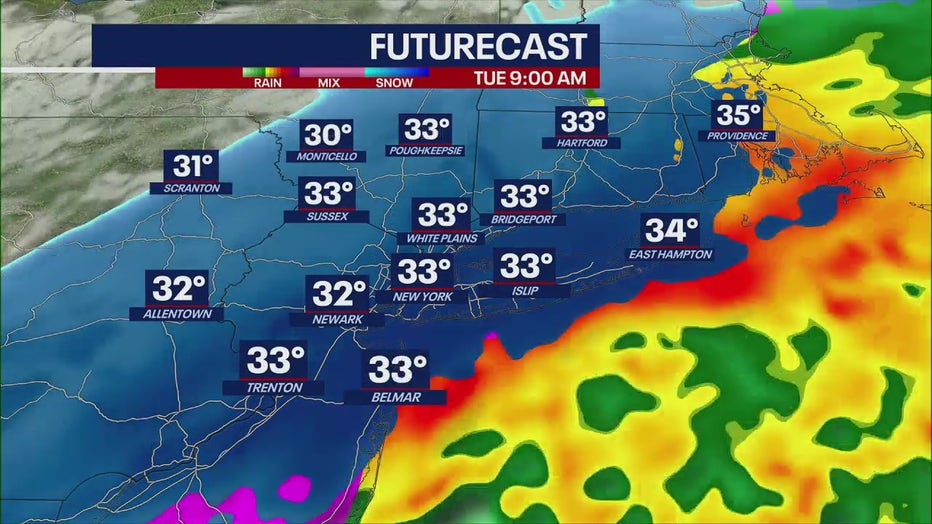
A wintry mix moving north to south as snow is taking over. Temperatures are in the lower 30s, lingering around the freezing mark in NYC.
"It's looking like that rain-snow line has been sinking down to the south, and all together, it looks like it's going to sink a little further than what it appeared to," FOX 5 NY's Mike Woods said.
7 a.m. to noon
The entire area should see snow as the morning commute picks up. Temperatures will remain in the lower 30s during snowfall.
NYC and NJ -- don't be surprised if you hear thunder during today's snowfall! That shows just how intense this storm is shaping up to be.
Snow will fall fastest during commuting hours, at rates of 1 to 2 inches per hour. Expect 20 to 25 mph winds with gusts up to 40 in the city and on Long Island.
"We're strongly encouraging New Yorkers, if you don't have to go out, stay home," NYC Mayor Eric Adams said Monday.
1 p.m.
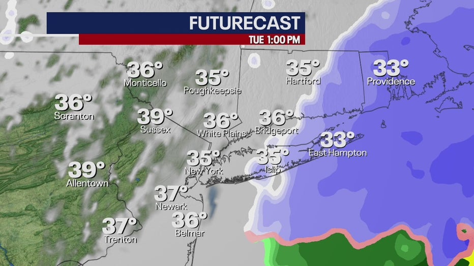
The system moves almost entirely out of the area, and by tomorrow afternoon, conditions will calm from west to east. Temperatures will reach the mid 30s in the city.
6 p.m.
The Winter Storm Warning ends.
How much snow should the NYC area expect?
According to FOX 5 NY meteorologist Nick Gregory's forecast, northern New Jersey, the Lower Hudson Valley and the interior of Connecticut will see 9 to 12 inches of snow.
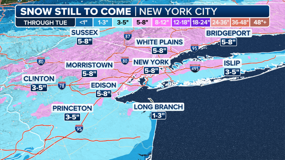
New York tri-state area snowfall forecast from Monday into Tuesday, Feb. 12-13, 2024. (FOX Weather)
New York City, Long Island and metro New Jersey will see 6 to 8+ inches.
Expected snow totals actually drop in the northern Tri-State counties, like Dutchess and Putnum, which should expect only 3 to 5 inches.
Worst-case scenario
If heavy snow banding is persistent, NYC could see 13 inches of snow. Areas north and west of the city would see 14 to 16 inches, while Long Island would record 9 to 10 inches.
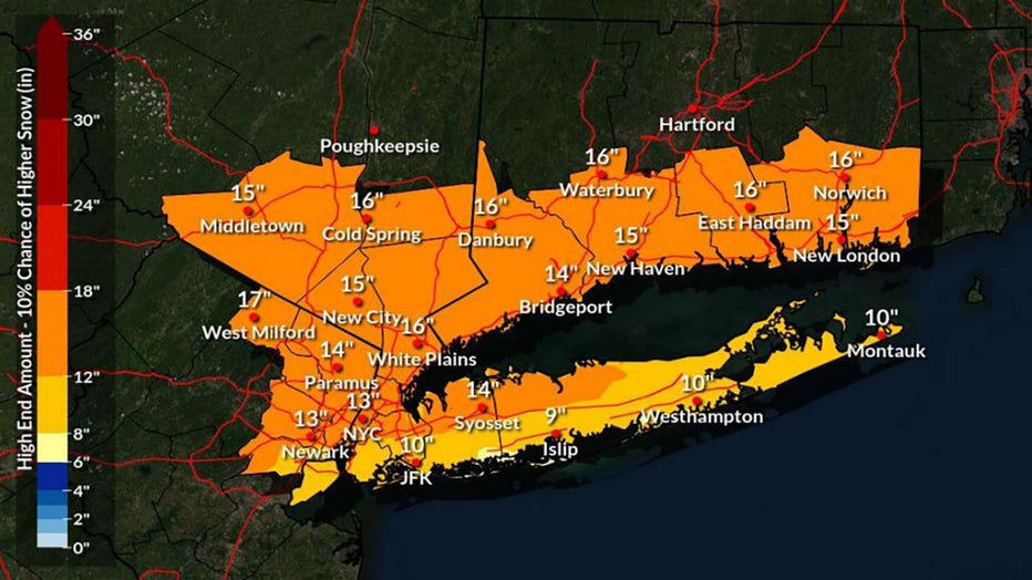
High-end amount of snow totals for Tuesday's storm
On the flip side, if the storm trends further south and the rain-to-snow changeover is slow, NYC will only see 4 inches of snow. Some northwestern areas would see 4 to 6 inches, while parts of Long Island would see little to no accumulation.
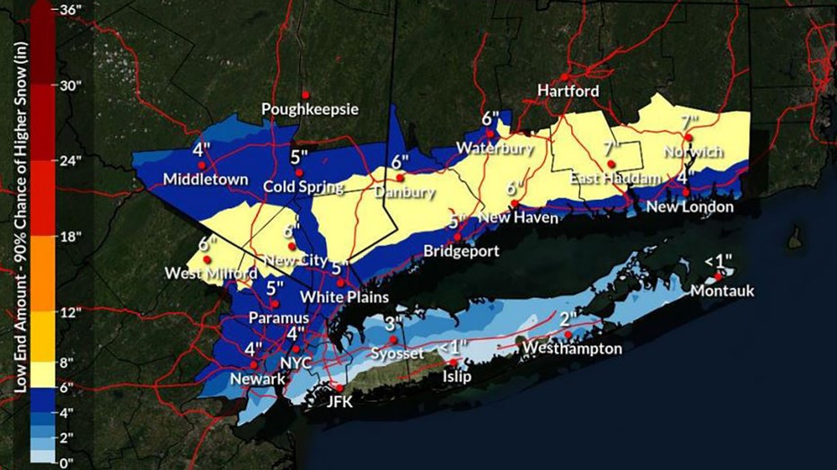
Low-end amount of snow totals for Tuesday's storm
More watches, warnings and advisories
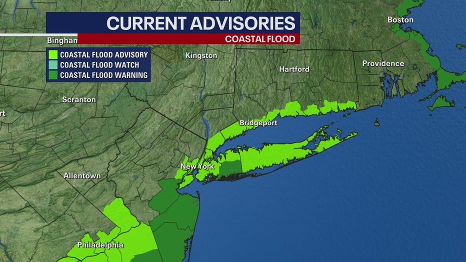
The snow, combined with wind gusts of 30 to 40 mph could cause some power outages, while a Coastal Flood warning has been issued for southern Nassau County and a Coastal Flood Advisory is in effect for much of the rest of New York City, Long Island, southern Connecticut and eastern New Jersey.
Mid-winter weather outlook: ‘6 more weeks’ of winter
New York City's Central Park has recorded a measly 2.3 inches of snow this winter, but FOX 5 NY’s Nick Gregory said the area has the potential for at least another 15 inches, according to his mid-winter forecast.
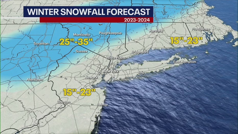
Only one or two decent storms will help us reach this projected total, and Nick forecasts that February will provide the perfect conditions for winter storm development.
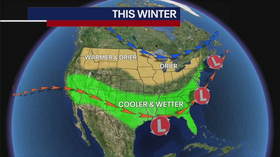
The U.S. is experiencing a strong El Niño, meaning the Tri-State is more likely to see warmer-than-average temperatures and wetter-than-average precipitation.
As we move forward, strong El Niño conditions will continue, meaning February will feature the same type of weather we've seen: above-average temperatures and borderline rain-snow events.
"I think winter will be prolonged here, and I do think that we'll probably have a good surge of cold weather coming in the middle part of February, [creating the potential for a snow storm or two," Nick said.