

February 2026 blizzard totals: How much did it snow across the Northeast US?
NYC weather: Snow totals, records, forecast for the week
FOX 5 NY's meteorologist Audrey Puente has the latest.
NEW YORK - A major nor’easter that intensified offshore brought heavy snow and strong winds across a wide stretch of the Northeast, leaving a broad range of storm totals from Virginia and the DC region to New York, New Jersey and Connecticut.
RELATED: More snow to hit NYC area after record blizzard: See latest forecast for Tuesday
What we know:
The storm produced blizzard-like conditions in parts of the region and dumped significant snow across multiple states. Peak storm totals by state included 14 inches in Virginia, 16 inches in Maryland, 21 inches in Delaware, 22.1 inches in Pennsylvania, 30.7 inches in New Jersey, 31 inches in New York and 30.8 inches in Connecticut.
FIND THE LATEST NY WINTER WEATHER FORECAST HERE

NEW YORK, UNITED STATES - FEBRUARY 23: Passengers wait for the train in deep snow after a powerful, multi-day blizzard dumped about 19 inches of snow in Long Island City, New York, United States on February 23, 2026. (Photo by Selcuk Acar/Anadolu via
Pennsylvania
Parts of the Philadelphia region reported snowfall well into the teens.
- Northeast Philadelphia: 16.0 inches
- Philadelphia International Airport: 14.0 inches
- Fox Chase: 14.8 inches
- Norristown: 13.4 inches
- Willow Grove: 13.2 inches
- Skippack: 12.8 inches
New Jersey
Snow totals exceeded 2 feet in several New Jersey communities.
- Moonachie: 24.3 inches
- Ridgefield: 23.2 inches
- Leonia: 22.0 inches
- Carlstadt: 21.4 inches
- Orange: 24.0 inches
- Montclair: 19.0 inches
- Kearny: 19.0 inches
- Hoboken: 18.5 inches
- Newark Airport: 18.3 inches
- Freehold: 26.0 inches
- Middletown: 25.0 inches
- Perth Amboy: 25.0 inches

NEW YORK, NEW YORK - FEBRUARY 23: A man carrying flowers walks through the snow in the Lower East Side on February 23, 2026 in New York City. A major winter storm has hit the Northeast and Mid-Atlantic regions bringing heavy snowfall and blizzard con
Delaware
Delaware recorded widespread double-digit snowfall totals.
- Woodside: 20.5 inches
- Dover: 16.5 inches
- Felton: 17.5 inches
- Wilmington: 9.5 inches
- Hockessin: 10.0 inches
- Long Neck: 19.3 inches
- Delaware Coastal Airport: 19.0 inches
- Lewes: 18.0 inches
Stay connected with FOX LOCAL. For 24/7 winter storm coverage—Download Now.
New York
Snow totals across New York City and Long Island ranged from the mid-teens to more than 2 feet.
- Mott Haven (Bronx): 17.9 inches
- Co Op City (Bronx): 14.8 inches
- Sheepshead Bay (Brooklyn): 20.5 inches
- Bay Ridge (Brooklyn): 16.9 inches
- Washington Heights (Manhattan): 18.9 inches
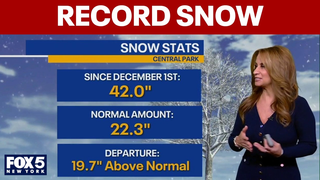
- Central Park (Manhattan): 15.1 inches
- Jackson Heights (Queens): 17.0 inches
- LaGuardia Airport: 15.1 inches
- JFK Airport: 15.0 inches
- Grasmere (Staten Island): 24.1 inches
- Remsenburg-Speonk (Long Island): 27.5 inches
- Central Islip: 27.0 inches
- Islip Airport: 22.5 inches
RELATED: What are the biggest snowstorms in NYC area history?
Connecticut
Connecticut communities reported widespread totals in the teens, with some nearing or exceeding 20 inches.
- New Fairfield: 18.0 inches
- Bridgeport Airport: 16.0 inches
- Madison: 19.9 inches
- New Haven: 16.0 inches
- Ledyard Center: 20.0 inches
- Mystic: 18.5 inches

NYPD officers pelted with snowballs at Washington Square Park
Good Day anchor Dan Bowens has the latest.
Virginia
Snow totals varied across Northern Virginia, with higher amounts in some western suburbs.
- Reston: 4.5 inches
- Falls Church: 3.5 inches
- Dulles International Airport: 2.0 inches
- Reagan National Airport: 1.0 inch
Washington, D.C.
Accumulations in the District remained relatively modest compared to areas north and east.
- Catholic University: 3.6 inches
Maryland
Maryland saw a wider range of snowfall totals, with double-digit amounts in some communities.
- Long Green (Baltimore County): 5.1 inches
- Damascus (Montgomery County): 7.1 inches
- Sabillasville (Washington County): 12.3 inches
What we don't know:
Snow totals can shift as National Weather Service offices and local spotters complete final storm surveys, and as drifting is factored into measurements in wind-prone areas. Some community reports may also be updated as additional observations come in.
Weather NYC this week: More snow expected
What's next:
Forecasters say the region will remain mostly dry through Tuesday, though a few snow showers could brush parts of Sullivan County due to lake-effect activity. Steadier snow is expected to move in after midnight and continue into Wednesday morning, potentially impacting the morning commute before tapering off Wednesday afternoon.
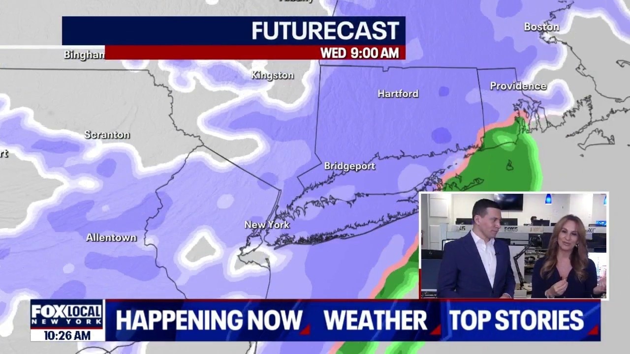
Upcoming snow threats this week for NYC area
FOX 5 NY's Audrey Puente joined Newsroom Live with Dan Bowens to talk about upcoming snow threats for the New York City area.
"This is not another blizzard. That’s some good news," FOX 5 NY meteorologist Audrey Puente said. "But there will be more snow to add to the totals that we’ve already seen."
- RELATED: How to shovel snow without a shovel
Another system could bring additional snow Thursday. Puente said that storm is expected to track to the south, but if it shifts slightly north, the tri-state area could see additional accumulating snow. Residents are urged to use caution on untreated roads and allow extra travel time as cleanup efforts continue.
The Source: This article was written using information from FOX 29 Philadelphia, FOX 5 DC and FOX 5 New York.