

Winter storm bears down on southern NJ

NEW YORK - A winter storm is expected to bring significant snowfall, with southern New Jersey potentially seeing more than six inches of snowfall.
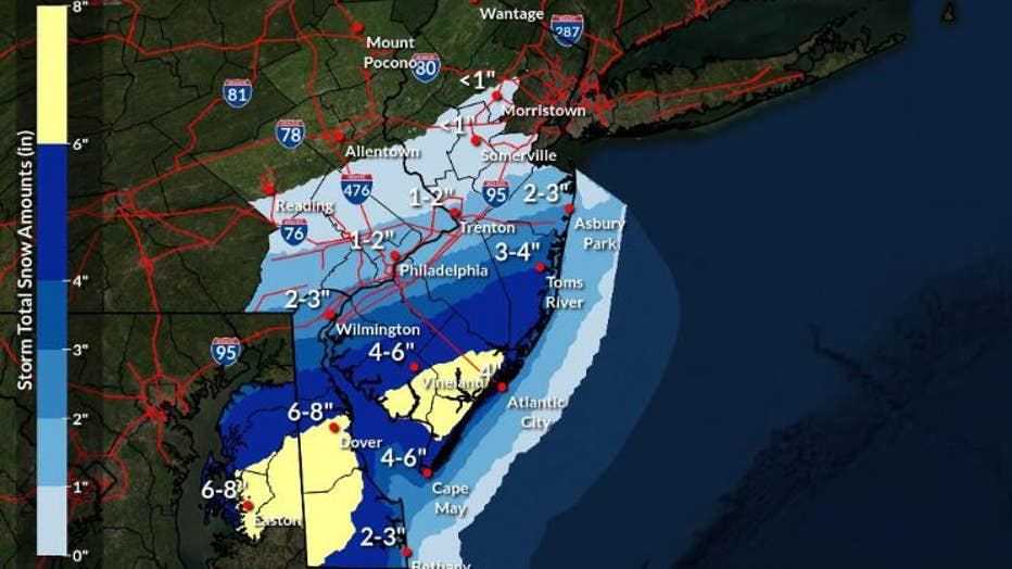
According to the National Weather Service, a winter storm warning has been issued for much of the southern coast of New Jersey, running from Cape May all the way to Toms River in Ocean County.
People in those areas are being told to expect heavy snowfall, with amounts of at least 6-8 inches falling in some areas and snowfall rates of over an inch per hour.
In response, Governor Phil Murphy announced that Atlantic, Burlington, Cape May, Cumberland, and Ocean counties under a state of emergency Sunday night.

Winter storm bearing down on NY and NJ
Some parts of New Jersey could see as much as 6 inches of snow from a winter storm set to sweep through the region.

Credit: National Weather Service Philadelphia/Mount Holly
Credit: National Weather Service Philadelphia/Mount Holly
Snowfall is expected to result in treacherous driving conditions and locally, some areas may see more than eight inches of snowfall.
Murphy urged residents to stay inside and suggested remote work if possible to skirt a potentially dangerous Monday commute.
A coastal flood advisory has been issued for most of New Jersey, New York City, and all of Long Island, as Monday morning's high tide may bring up to half a foot of water above ground level in vulnerable areas near the waterfront and shoreline.
New York City could see about an inch of snow, with the southern shore of Long Island seeing a few inches of snow.
The New York City Department of Transportation announced that Alternate Side Parking rules would be suspended Monday for snow operations, while NYC Emergency Management issued a travel advisory for Monday due to expected snowfall.
A travel advisory was posted for New York City as a precaution.
The sudden snowfall comes after a day of warm weather that either set or tied records across the region, with new watermarks of 59 and 58 degrees being set at JFK and Islip Airport, and a high of 60 degrees at La Guardia Airport tying a previous record set in 2000.
Get breaking news alerts in the free FOX5NY News app! | Sign up for FOX 5 email newsletters
The storm is expected to be much stronger south of New Jersey.
The winter storm packing heavy snow was expected to roll into the District of Columbia, northern Virginia and central Maryland early Monday, bringing up to 10 inches of snow to the area through the afternoon.
The National Weather Service issued a winter storm warning for the area until 4 p.m. EST Monday. Wind gusts of up to 35 mph (56 kph) were forecast, and travel was expected to be very difficult because of the hazardous conditions, the weather service said.
"The timing of this isn't great," said National Weather Service meteorologist David Roth. "For the D.C. area, it's morning rush hour. At least for places to the northeast, it'll be closer to midday."
The Weather Prediction Center said 2 inches (5 centimeters) of snow per hour could fall in some areas, and thunder snow was possible. Localized snowfall totals could reach 10 inches (25 centimeters).
In Washington, the U.S. Office of Personnel Management announced that federal offices in the area would be closed on Monday. Emergency employees and telework employees would continue to work, the OPM said on its website.
Several school districts in the region said they would be closed, delayed or have virtual learning Monday. DC Public Schools said students and staff wouldn’t be returning to school until Thursday.
The Associated Press contributed to this report.