

NYC snow forecast: Winter storm could bring 1-3 inches, disruptions to Tuesday commute

NEW YORK CITY - Tuesday's weather forecast shows NYC could finally see measurable snow accumulation, as an arctic blast and low-pressure system could create the perfect conditions to break a "no-snow" streak. Snow total predictions are as high as 3 inches!
CLICK HERE FOR LIVE RADAR
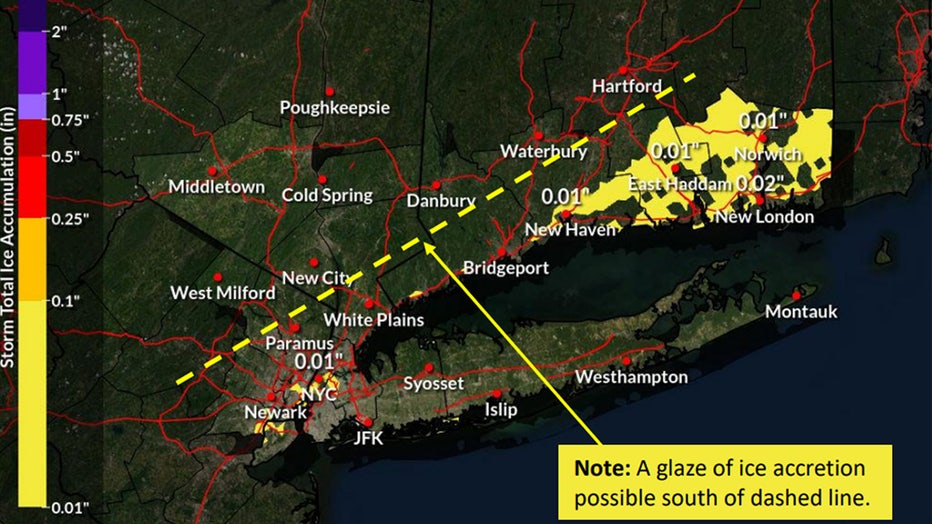
Conditions, however, will not be ideal for commuting, as the potential for a glaze of ice could impact the NYC/NJ metro area, Long Island and southwest CT. Winter weather advisories are already in place across parts of the tri-state area.
Here's the rundown of events across the tri-state area, including a weather forecast timeline, snow total predictions and when the next round of snowfall is expected to hit.
MORE: NY, NJ, CT school closings
When will it snow in NYC? Weather forecast timeline
Monday
Winter weather advisories are in place from 8 p.m. Monday until 1 p.m. Tuesday for all of New Jersey and New York City, as well as parts of Connecticut and Long Island.

Winter weather advisories across the tri-state area.
The Martin Luther King Jr. holiday will feature chilly temperatures that will stay in the 30s, but the chance for snow comes later.
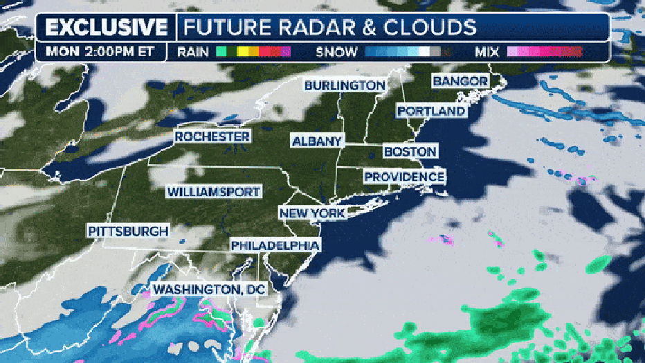
The FOX Model snows snow for New York and Philadelphia but they are very close to the rain snow line. (FOX Weather)
Temperatures are forecast to dip into the low 20s in the evening as an arctic blast from the north hits.
A light, powdery snow will likely develop around 7 p.m. and continue overnight. At some points, the NYC area could see up to a half an inch of snow falling per hour, according to the NWS.
Tuesday
By Tuesday morning, the snow could become wet and heavy. A possible combination of snow, rain and ice could create challenging travel as most people head back to work and school. A high of 34 is forecast for New York City.
A glaze of ice accretion is possible Tuesday morning, according to the NWS.
The snow could recede by the afternoon, and a mix of rain and snow could continue until around 4 p.m.
Skies will gradually clear Tuesday evening, but temperatures will remain cold, with a low around 22 degrees.
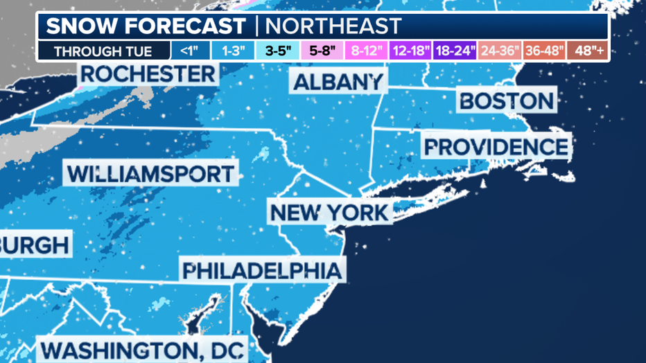
How much snow could we see? Expected snowfall totals
According to the National Weather Service, there is a 70% chance of snow with accumulation of roughly 1 to 3 inches possible by Wednesday morning. So far, New York City is 8.6 inches below average for snow this season.
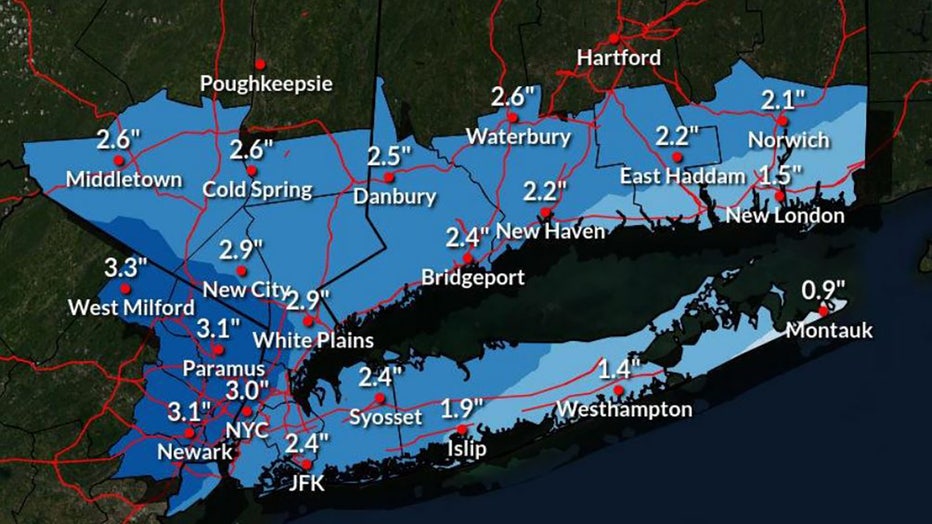
Expected snowfall totals in the NYC area after Tuesdays storm
Here are the expected snowfall totals throughout the region:
NYC and Long Island
- NYC: 3.0"
- JFK Airport: 2.4"
- Syosset: 2.4"
- Islip: 1.9"
- Westhampton: 1.4"
- Montauk: 0.9"
New Jersey
- Newark: 3.1"
- Paramus: 3.1"
- West Milford: 3.3"
Lower Hudson Valley
- White Plains: 2.9"
- New City: 2.9"
- Cold Spring: 2.6"
- Middletown: 2.6"
Connecticut
- Bridgeport: 2.4"
- Danbury: 2.5"
- New Haven: 2.2"
- Waterbury: 2.6"
- East Haddam: 2.2"
- Norwich: 2.1"
- New London: 1.5"
Expected snowfall totals in the NYC area after Tuesdays storm
Will NYC see snow later in the week?
If New York City can't get the inch this week, keep an eye on the forecast for next week to break the streaks.
The rest of the week should see temperatures that struggle to make it out of the 30s.
"There are suggestions that we'll see kind of the same pattern, the same track. Another storm developing out of the Gulf and racing northeastward toward the Atlantic and the East Coast," Winter Storm Specialist Tom Niziol said. "Still a little too far out, that energy's way out in the Aleutians right now, to detail what's going to happen there. But keep your guard up as we go into the end of the week in the Mid-Atlantic and in the Northeast for what could be a little more significant winter weather event there."
New York's record snowless streak
The city continues its recording-breaking snowless streak.
As of Monday, Jan. 15, it's been 701 days since the Big Apple picked up at least an inch of snow in a single calendar day. Central Park picked up 1.6 inches of snow on Feb. 13, 2022.
Featured

NYC reaches day 701 without at least 1 inch of snow
As of Monday, Jan. 15, it's been 701 days since the Big Apple picked up at least an inch of snow in a single calendar day.
That's almost two years without the white stuff.
This breaks the previous streak of 383 days that ended in March 1998.
The Big Apple only saw 2.3 inches of snow over the winter of 2022 through all of 2023. That is more than a 2-foot deficit compared to the average winter season snowfall and a record for the lowest annual snowfall total.
FOX Weather helped contribute to this report.