

Snowstorm NYC: Nor'easter targets NY
NEW YORK - This story is no longer being updated. CLICK HERE FOR LATEST NY SNOWSTORM COVERAGE
Winter Storm Warnings are posted for much of the New York City region ahead of a nor'easter winter storm that will bring snow, wind, and coastal flooding. With the storm tracking on a more westerly track the expected snow total are higher than originally forecast.
Blizzard Warnings are also in effect from Friday 7 p.m. until Saturday 7 p.m. for Atlantic County, Cape May County, Ocean County and Monmouth County in New Jersey. The National Weather Service considers the risk of blizzard conditions along the coast as extreme.
Nor'easter NYC
The powerful nor'easter will develop off the East Coast today and is expected to bring heavy snowfall to New Jersey, New York, the Jersey Shore, eastern Long Island, and New England. (What is a nor'easter? Here is what you need to know.)
"Snow may be heavy at times through early Saturday afternoon before diminishing late in the day. Winds may generate areas of blowing snow and low visibilities at times," the National Weather Service said. "The storm total snow forecast remains a bit uncertain as there will likely be a sharp cutoff in the northwest extent of the highest snowfall totals, so stay tuned to the latest forecasts."
A watch does not mean a large snowfall is guaranteed. Watches mean there is the potential to see moderate to heavy snow. Warnings mean that there is more of a likelihood that the storm will have greater impacts.

NY Nor'easter forecast
A major winter storm will hit NYC and surrounding areas Friday into Saturday bringing blizzard conditions in some areas.
NYC Weather
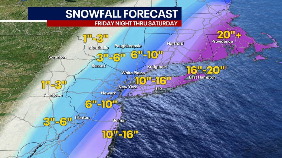
New York City could see as much as 10 inches of snow, while much of Long Island could see more than a foot and eastern Long Island as much as 20 inches of snow.
Portions of central and southern New Jersey could see total snow accumulations of 6 to 16 inches with winds gusting as high as 50 mph.
"Snow is expected to begin Friday evening in… southern New Jersey, spreading northward overnight into Saturday morning," the National Weather Service said. "Snow may be heavy at times through mid-afternoon Saturday before diminishing Saturday evening. Strong winds may generate blowing snow and very low visibilities at times."
In northern New Jersey, total snow accumulations of 10 to 16 inches are possible with winds gusting as high as 35 mph. Areas along the Jersey Shore could see 18 inches of snow.
The current forecast shows that eastern Long Island and southeastern Connecticut could get 16 to 20 inches of powdery snow with snowfall rates of 1-2 inches per hour at the storm's peak intensity. Travel will be difficult and near-blizzard conditions are possible. Forecasters expect scattered downed tree limbs and power lines and some downed trees. That means power outages are possible.
The National Weather Service updated its forecast for New York City, northeast New Jersey, southwest Connecticut, and much of Lower Hudson Valley to indicate that heavy snowfall is now more likely.

Weather Forecast
Meteorologist Audrey Puente says there is the threat of a few flakes today ahead of a big winter storm beginning tonight. New York City could see 6-10 inches of snow with higher totals east of the city. Today's high is 35.
"Confidence is increasing for a strong storm system to bring moderate to heavy snowfall and strong winds to much of the area Friday night through Saturday," the National Weather Service said.
Minor to locally moderate coastal impacts are possible for Long Island's north shore, twin forks, and barrier island shoreline communities. There could also be scattered dune erosion.
On the ocean, there could be gale conditions. Seas of 10-15 feet are expected. Seas of 4-6 feet in the central and eastern Long Island Sound.
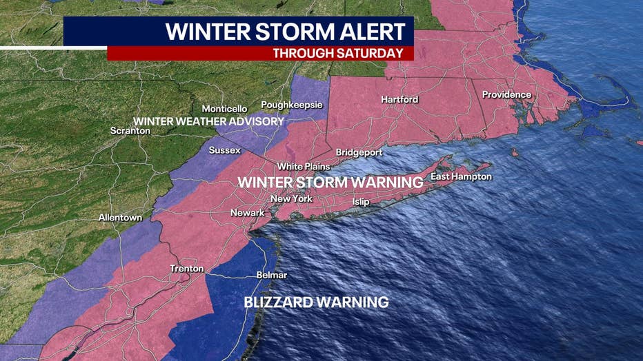
Winter storm watches and warnings are posted across the New York City metro region. (FOX 5 NY)
Explosive cyclogenesis
The nor'easter is expected to intensify into a bomb cyclone, a term used to describe a low-pressure system that undergoes "bombogenesis" – defined as a rapid pressure drop of at least 24 millibars in 24 hours or less – indicative of a very intense storm.
Winter storm timing
The snow is expected to develop on Friday with the heaviest snow possible from late Friday night into Saturday afternoon. The snow is expected to taper on Saturday evening.
The peak winds will be on Saturday morning into early Saturday evening.
The coastal flooding risk will be highest at high tides on Saturday and Sunday morning.
Ocean storm impacts will be greatest from Friday night until Saturday night.
Nor'easters in NYC area: What you need to know
A nor'easter, also known as a northeaster, is a type of potentially powerful storm that affects the East Coast of the United States and Canada. The storms are known for especially impacting the very heavily populated region connecting Washington, D.C., Philadelphia, New York City, and Boston. Here is more you need to know about how nor'easters affect the NYC area.
Download the FREE Fox 5 NY weather app and always stay updated on storms.
Apple App Store: https://apple.co/2GrlPnz Google Play Store: http://bit.ly/2IPSlTd