

NYC summer 2024 forecast: Hurricane projections, heat/rain trends and more

NYC summer 2024 forecast
Those lazy, hazy, crazy days of summer are here – and so is FOX 5 NY's weather outlook for summer 2024 in NYC!
NEW YORK CITY - Those lazy, hazy, crazy days of summer are here – and so is FOX 5 NY's weather outlook for summer 2024 in NYC!
JUMP TO: HEAT STATS l HURRICANE FORECAST l SUMMER OUTLOOK
While New Yorkers should anticipate lots of fun in the sun, we can also be subject to scorching heat and high humidity, which can be dangerous if we're not careful.

NOAA: 2024 Hurricane season will be busy
The National Oceanographic and Atmospheric Administration has predicted an exceptionally busy hurricane season in the Atlantic Ocean for 2024.
As the summer of 2024 is about to kick off, what can we expect for this year?
NYC heat stats
For comparison, last summer wasn't too hot.
MORE: Heat wave forecast: Will NYC see a 100-degree day this week?
- 2023: 5 days of 90+ degrees
- 2022: 24 days of 90+ degrees
- The average is 15 days of 90+ degrees
- The last 100+ degrees day was July 18, 2012
- The hottest NYC day ever was 106 degrees on July 9, 1936
So far this year, it's been a pretty wet spring with over 15 inches of rain. Will this mean a wet summer is coming? Not necessarily.

Summer of extreme weather
It has been a year of extreme weather, and this summer is no exception. Extreme heat is wreaking havoc on communities from Arizona to Italy. FOX 5 NY's Audrey Puente takes a closer look.
In many cases, a wet spring can lead to a dry and rather hot summer. It all depends on if the wet pattern lasts into June.
El Niño Southern Oscillation
As always, to make a long range forecast, we have to research events taking place globally, like the one you always hear me talk about – the El Niño Southern Oscillation, or ENSO, for short. ENSO is measured in three phases:
- The El Niño phase
- The neutral phase
- The La Niña phase
All deal with measuring the departure from average of the Pacific Ocean sea surface temperatures along the equatorial latitudes.
El Niño phase
El Niño occurs when there's a warmer than average temperature, leading to a strong southern jet stream.
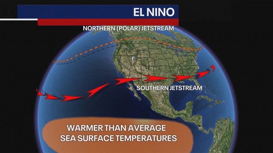
Most recently, we've been under the influence of a strong El Niño that resulted in a warmer than average winter and snowfall that was well below average.
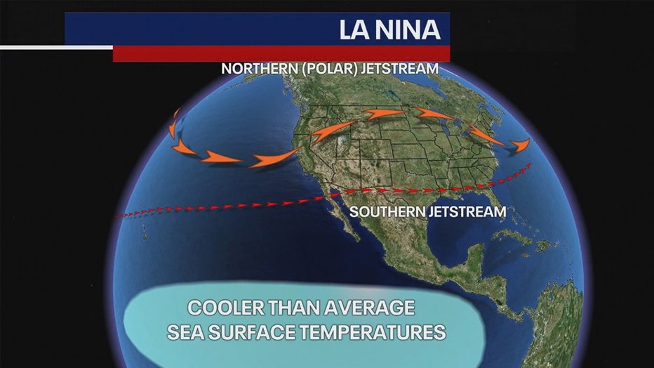
Neutral phase
We're now in the neutral phase, but we'll be transitioning into a La Niña situation during the summer. This means sea surface temperatures will be cooler than average, leading to a stronger northern jet stream.
El Niño and La Niña are more reliable in making a winter long range forecast, but we can look back to previous summers to see how La Niña played a role in our weather. We found that a La Niña pattern existed for the summers of 2000, 2008, 2010, 2016, 2020, 2021 and 2022.
It turns out that New York City ended up warmer than average by two to as much as 10 degrees during those summers. Rainfall was at or below average for most of them.
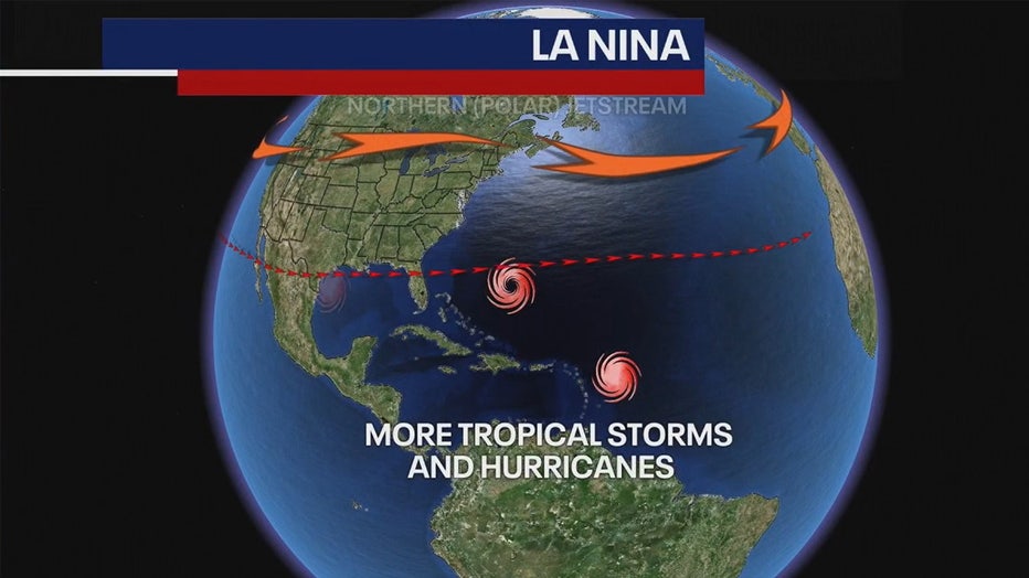
La Niña phase
A La Niña season can lead to another issue, a more active hurricane season.
Upper-level winds across the tropics can become much weaker, allowing for more storms to develop. This will particularly impact the Gulf of Mexico, along with the Florida Peninsula, but the East Coast of the U.S. will need to be on alert.
In addition, current Atlantic Ocean sea surface temperatures are near record warmth. This could result in more powerful storms that may rapidly intensify.
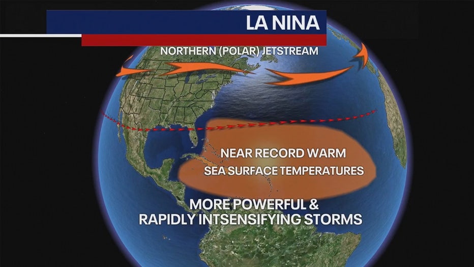
You may remember Hurricanes Charlie and Ian, which struck the southwest coast of Florida. Both storms went from category one to category four status and less than a day.
2024 hurricane forecast
In making the hurricane seasonal outlook, NOAA has issued its most aggressive forecast ever:
- 17–25 named storms (Average is 14)
- 8–13 hurricanes (Average is 7)
- 4–7 major hurricanes (Average is 3) – Meaning winds in excess of 111 mph.
2024 summer outlook
With La Niña forcing a stronger than average northern jet stream, NOAA is forecasting a warmer than average summer for just about everyone.

There is the potential for excessive heat in the west and in the southern plains.
In the northeast, we are looking at a summer of above average temperatures. As for rainfall, NOAA is calling for a drier than average summer out west, but for above average rainfall in the east, especially for the East Coast and the Southeast. Much of this could be a result of a more active hurricane season.
Tri-State Summer
So, what can we expect in the Tri-State area for this summer?
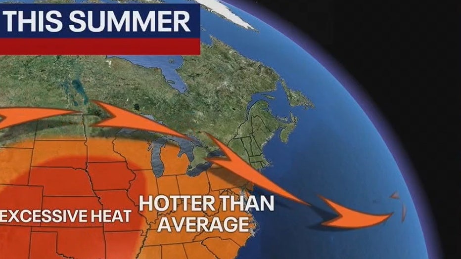
Well, we've been talking about La Nina, we've been talking about a farther northern jet stream and if this all materializes, we're likely to see a hotter than average summer for a good part of the country and excessive heat in the middle part of the country. I'm talking days on end where temperatures will be up over that 100-degree mark.
I don't think that excessive heat is going to make it to us.
- Hotter summer ahead with temps 2–3 degrees above average
- 20 days with temperatures in the 90s
- Close to average rainfall, around 14 inches (Hurricane season is the wildcard)