

Is snow going to stick in your area? Forecast for NY, NJ, CT
NEW YORK CITY - Is snow going to stick in NYC this weekend? That depends. How about New Jersey? If you live above the Turnpike, most likely.
This weekend's storm is bringing heavy precipitation to the entire New York City area and snow accumulation north and west of the city.
Click here for live radar
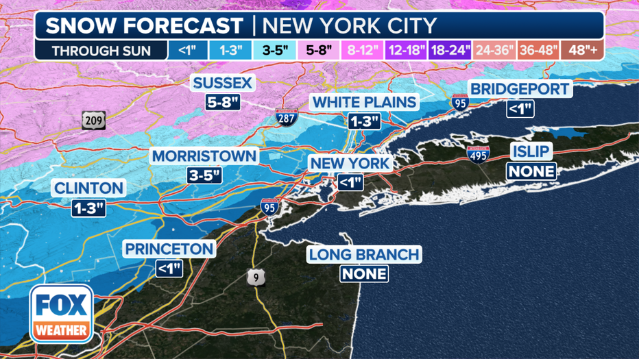
Forecast snow totals for the nor'easter in New York City area through Sunday.(FOX Weather)
While NYC has a chance of breaking the streak of no 1-inch snow days, total accumulation still depends on the intensity of snowfall and the timing of the snow-to-rain transition Saturday evening.
It is an incredibly tricky and uncertain forecast for New York City as the city will be on the rain-snow line for much of the storm.
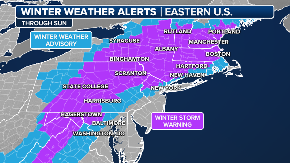
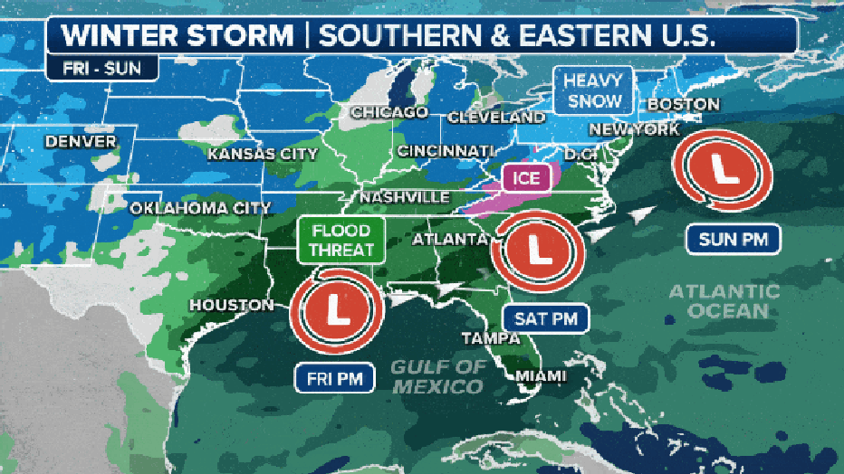
Current winter weather alerts in effect. (FOX Weather)
BOOKMARK: School closings and delays
How much snow are we getting this weekend?
- Due to the Atlantic Ocean's modification of the airmass, the heaviest snowfall totals are expected to fall well away from New York City, FOX Weather reports.
- Forecast models show the New York Tri-State area receiving upwards of 3" of snow through Sunday morning. Questions still remain over where the rain/snow line will end up.
- In northeast New Jersey, Lower Hudson Valley and southwestern Connecticut, 4-8"of accumulation is likely, though 10-12" is possible for some areas.
- Closer to I-95 in NJ, NY and CT, total predictions lower to 2 to 6".
Snow total predictions by city/town
New York/Long Island
- New York City: 2" high end/0 low end
- JFK: <1" high end/0 low end
- Syosset: 1" high end/0 low end
- Islip: <1" high end/0 low end
- Westhampston: <1" high end/0 low end
- Montauk: 1" high end/0 low end
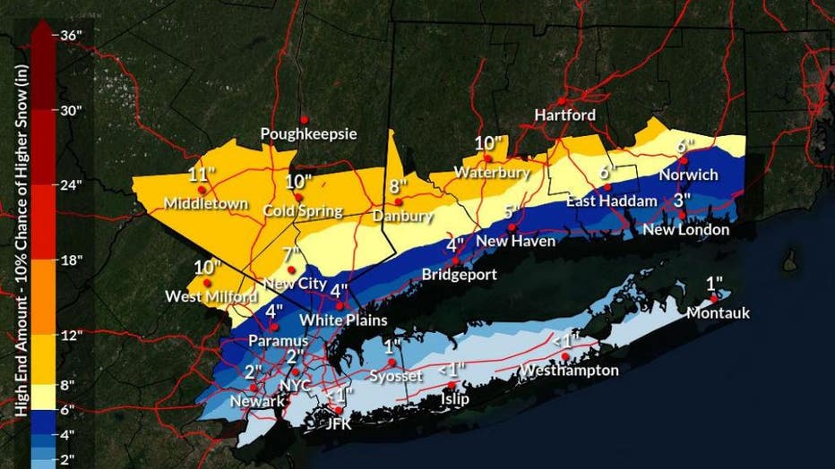
Hudson Valley
- White Plains: 4" high end/ 0 low end
- New City: 7" high end/3" low end
- Cold Spring: 10" high end/6" low end
- Middletown: 11" high end/7" low end
New Jersey
- Newark: 2" high end/0 low end
- Paramus: 4" high end/<1" low end
- West Milford: 10" high end/6" low end
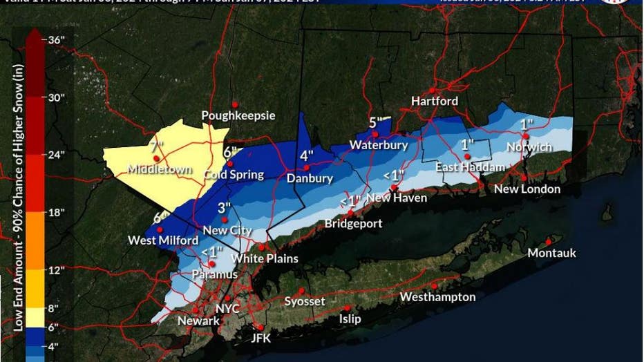
Connecticut
- Bridgeport: 4" high end/<1" low end
- New Haven: 5" high end/<1" low end
- Danbury: 8" high end/4" low end
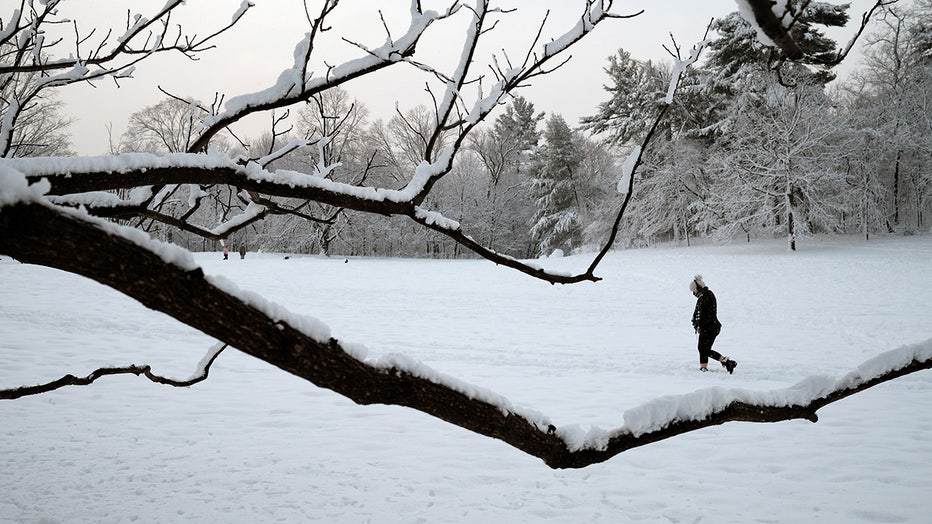
People walk through the snow following a storm in Prospect Park on February 07, 2021 in the Brooklyn borough of New York City. (Photo by Spencer Platt/Getty Images)
When was the last notable snow storm in New York City?
Snow lovers should feel hopeful about the weekend, even several days out, because the current storm track is promising. We have to look back to late January 2022 to find the last notable snowstorm on the I-95 corridor. On Jan. 28-29, 2022, a nor'easter buried parts of the region under snow and even touched off blizzard conditions.
The 2024 storm will develop off the Gulf Coast and track offshore around the Carolinas. The 2022 nor'easter developed in the Atlantic off the Carolinas and traveled northward several hundred miles off the East Coast. (FOX Weather)
Cold air in place in 2022 turned all precipitation into snow. Delaware and eastern New Jersey not only saw over a foot of snow, but winds gusting between 50 and 60 mph blew around the snow, turning the storm into a blizzard, according to the National Weather Service.
Blizzard conditions pushed into New England on Jan. 29. New York City saw 8.5 inches of snow.
Storm could end NYC's record no-snow streak
Long ago, New York City clobbered its old record of 383 days without an inch of snow that ended in 1998.
New York City only saw 2.3 inches of snow over the winter of 2022 through 2023. That is more than a 2-foot deficit compared to the average winter season snowfall and a record for the lowest annual snowfall total.
FOX Weather helped contribute to this report.