

NYC snow storm Tuesday: Winter storm warnings issued in NYC-area
Click here for latest winter storm warning, snow forecast for NYC.

Snow returns to NYC Tuesday
Will New York City see measurable snow Tuesday? FOX Weather breaks down why big questions remain for next week's storm.
Will NYC see measurable snow just before Valentine's Day?
Winter Storm Warnings were issued north and west of NYC Sunday night.
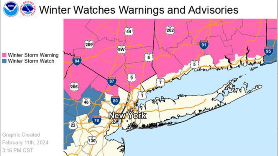
(National Weather Service)
The storm will certainly mess with the morning commute, but just like your favorite romantic comedy, it’s giving us the "will they/won’t they" for snow accumulation in NYC Tuesday.
Chances of seeing 6 inches or more inches of snow were 14% as of Sunday morning, according to the National Weather Service, but the possibility of a washout remains.
Here's what you need to know about Tuesday's winter storm, from a weather forecast timeline to projected snow totals:
Weather forecast timeline: What to expect snow through Tuesday
Sunday
Sunday evening will see lows in the upper 30s/lower 40s.
Monday
The day starts off sunny and pleasant, with a high of 49.
Monday evening
Temperatures will be warm enough on Monday that the storm will likely begin as rain across the area. But as the system continues to advance to the northeast and eventually moves off the East Coast, it will begin to pull in the colder air from the north and Canada, which will change the precipitation over to snow.

Tuesday at 1 a.m.
A Winter Storm Warning is in effect for inland northeast New Jersey, the Lower Hudson Valley and southern Connecticut.
"The storm will bring a period of moderate to heavy snow inland, and rain transitioning to a rain/snow mix down to the coast," according to the NWS.
A wet snow could fall at rates as fast as 2 inches per hour in these inland communities.
Tuesday morning
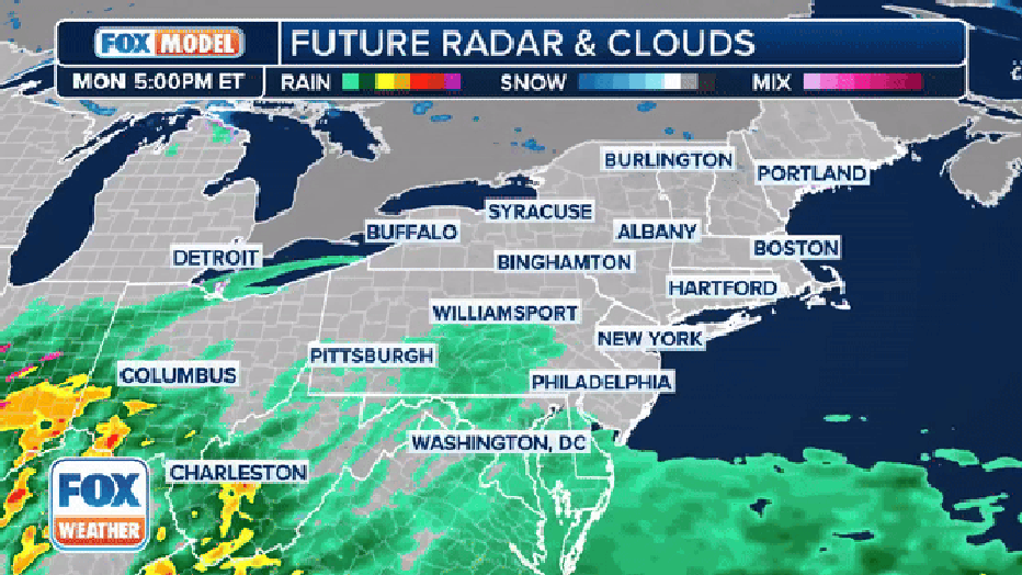
The exclusive FOX Weather future radar and clouds showing the potential nor'easter this week. (FOX Weather)
Conditions will likely make commuting hazardous, and schools across the region will likely be closed.
Just after the evening commute, rain is forecast to transition to snow in New York City.
If the storm tracks north and temperatures remain above freezing, NYC will see zero to very little accumulation. However, a more southern track mixed with cooler temperatures would potentially increase snowfall totals down the coast.
Tuesday at 10 a.m.
The Winter Storm Warning ends. Skies are forecast to clear by nightfall.
How much snow will we see in NYC and the Tri-State?
By the pre-dawn hours of Tuesday, widespread snow is expected across portions of New York, New Jersey and Connecticut. Yet where the rain/snow line falls will impact snow totals.
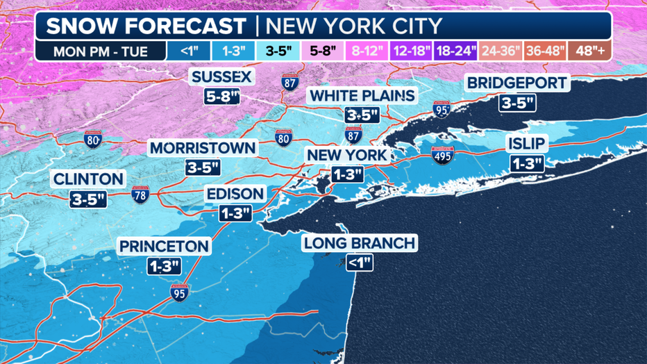
New York tri-state area snowfall forecast from Monday into Tuesday, Feb. 12-13, 2024. (FOX Weather)
Projected snow totals
New York City
- Central Park: 1.4"
- JFK Airport: 0.9"
Long Island
- Syosset: 1.5"
- Islip: 0.8"
- Westhampton: 0.8"
- Montauk: 1.0"
Lower Hudson Valley
- White Plains: 3.7"
- New City: 6.3"
- Cold Spring: 7.8"
- Middletown: 9.1"
New Jersey
- Newark: 1.9"
- Paramus: 3.2"
- West Milford: 7.7"
Connecticut
- Bridgeport: 4.0"
- New Haven: 5.5"
- Danbury: 7.4"
- Waterbury: 7.9"
- East Haddam: 6.5"
- New London: 3.2"
- Norwich: 6.7"
What are the chances for heavy snow accumulation?
According to the NWS, NYC has a 14% chance of seeing 6 or more inches of snow if the storm tracks south with colder temperatures and heavier snow banding.
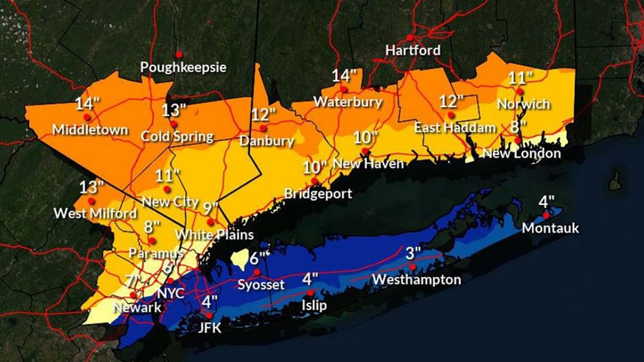
High end amounts of snowfall for Tuesday's winter storm
These conditions could also lead to over a foot of snow in the interior Lower Hudson Valley and Connecticut. Paramus could see 8 inches of snow, and parts of Long Island could see 6 inches.
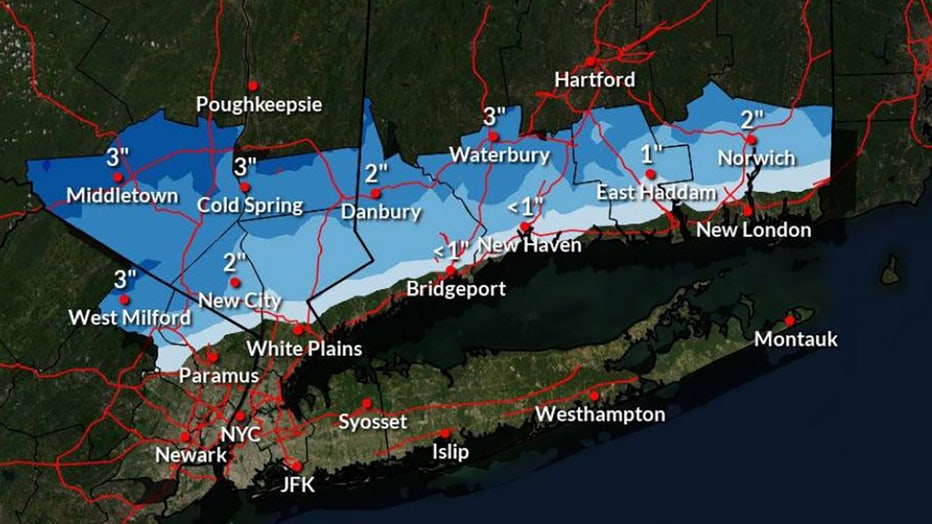
Low end amounts of snowfall for Tuesday's winter storm
On the flip side, the storm may also bring zero accumulation to New York, Long Island and metro New Jersey, with only one to two inches north and west of the city.
Mid-winter weather outlook: ‘6 more weeks’ of winter
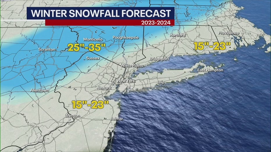
New York City's Central Park has recorded a measly 2.3 inches of snow this winter, but FOX 5 NY’s Nick Gregory said the area has the potential for at least another 15 inches, according to his mid-winter forecast.
Only one or two decent storms will help us reach this projected total, and Nick forecasts that February will provide the perfect conditions for winter storm development.
The U.S. is experiencing a strong El Niño, meaning the Tri-State is more likely to see warmer-than-average temperatures and wetter-than-average precipitation.
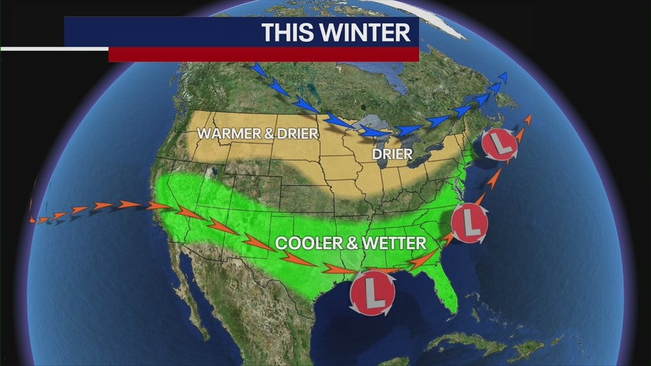
As we move forward, strong El Niño conditions will continue, meaning February will feature the same type of weather we've seen: above-average temperatures and borderline rain-snow events.
"I think winter will be prolonged here, and I do think that we'll probably have a good surge of cold weather coming in the middle part of February, [creating the potential for a snow storm or two," Nick said.