

Blizzard warning issued for NYC; Hochul declares state of emergency
NEW YORK - A major coastal storm is set to impact the Tri-State area Sunday into Monday, prompting blizzard warnings for New York City, Long Island and coastal Connecticut as forecasters call for heavy snow, strong winds and significant travel disruptions.
- Stay connected with FOX LOCAL. For 24/7 winter storm coverage—Download Now.
Blizzard warning NYC
NYC snow forecast: Blizzard warnings across the region
All of New York City and Long Island are under a blizzard warning on
What we know:
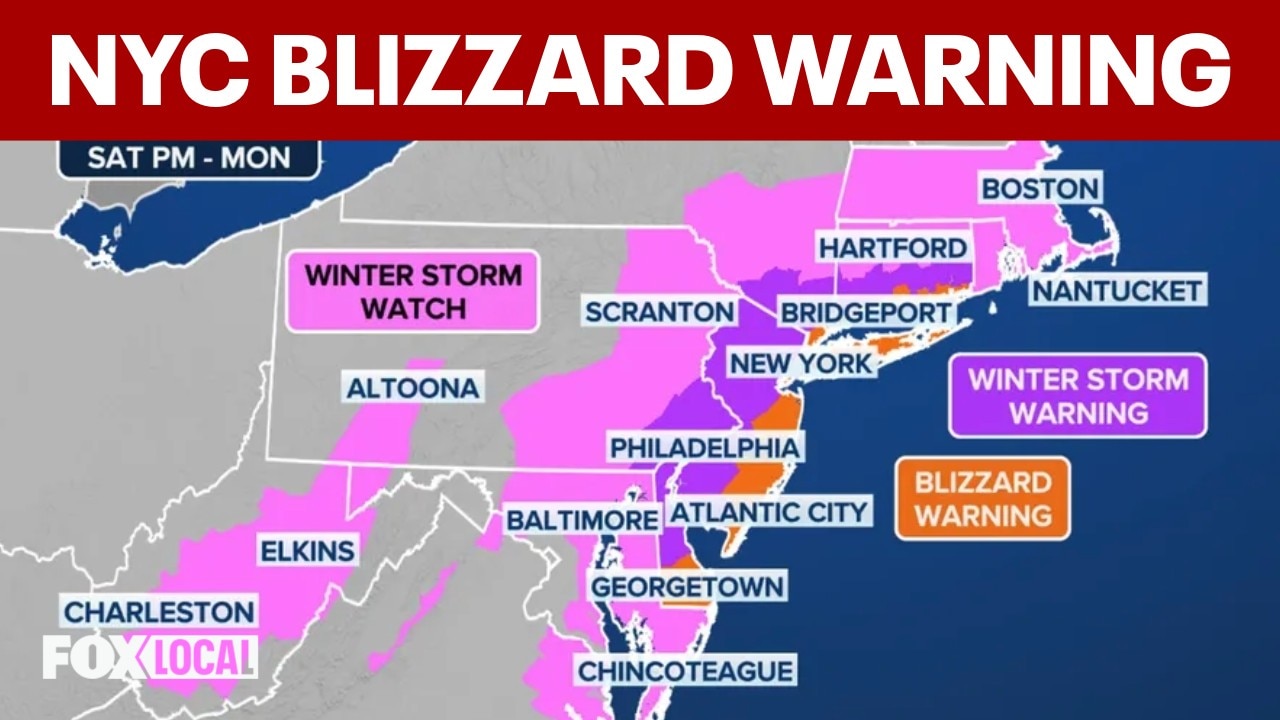
The National Weather Service issued blizzard warnings for NYC, Rockland and Westchester counties, all of Long Island and northeastern New Jersey and coastal Connecticut. These warnings start Sunday morning and continue through Monday afternoon.
Forecasters say those areas could see between 2 and 3 inches of snow per hour. Wind speeds between 30 and 45 mph are expected, with gusts potentially up to 60 mph. Officials say whiteout conditions could lead to "dangerous to impossible travel" from late Sunday through Monday morning.

Blizzard warnings and winter storm warnings in the NYC region as of 5 p.m. on Saturday, Feb. 21, 2026. (Credit: National Weather Service)
Meanwhile, winter storm warnings are in effect further inland in New Jersey, New York and Connecticut.
Officials say that
State of emergency in New York
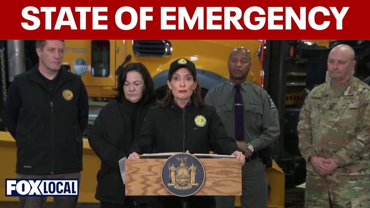
NYC blizzard: Hochul declares state of emergency
A major snow storm is making its way toward Long Island and New York City, with a blizzard warning going into effect on Sunday. Gov. Kathy Hochul has declared a state of emergency in 22 counties ahead of the storm.
What they're saying:
New York Gov. Kathy Hochul declared a state of emergency for 22 counties across the region, including all of NYC, from Albany through Long Island.
"We received word that it's even worse than we expected, and it is a rapidly deteriorating situation," Hochul said, adding that this storm "is one to take seriously."
Blizzard warnings in NY, NJ: region prepares for storm
More than 15 inches of snow are expected to fall on across the tri-state area starting Sunday, with heavy winds set to create blizzard conditions. States of emergency have been declared in all three states, and locals are preparing.
According to Hochul, the blizzard warnings issued are the first in NYC since 2017, and the first on Long Island since 2022.
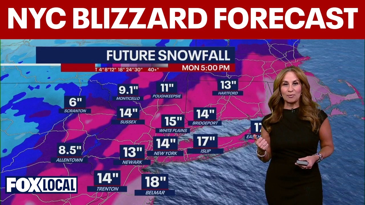
How much snow will NYC get this weekend?
By the numbers:
Blizzard conditions — defined as sustained winds or frequent gusts above 35 mph combined with falling or blowing snow reducing visibility to a quarter mile or less — are expected along the coast, including the NYC metro area.
Snow predictions for Sunday

Snowfall totals
- NYC: 17–19 inches likely, with the potential for more than two feet of snow in some places.
- Long Island: 19–20 inches likely, with locally higher amounts possible
- Northeastern NJ: 15–17 inches, with higher amounts possible
- Coastal Connecticut: 15–16 inches likely, with higher amounts possible.
Snowfall rates
- 1–2 inches per hour expected, with potential for 3+ inches per hour late Sunday through Monday morning.
- 2 inches per hour or greater possible Sunday night into Monday morning
Winds
- N/NE winds 30–35 mph
- Gusts up to 55 mph possible along the coast
When will snow start on Sunday?
Timeline:
Here is a timeline for when snow will start, according to the National Weather Service:

FOX Forecast Center is monitoring the potential for blizzard conditions along the East Coast ahead of a nor'easter packing heavy snow and high winds. (FOX Weather)
- Sunday morning/afternoon: Snow develops, possibly mixing briefly with rain near the coast at the start
- 7 PM Sunday – 12 PM Monday: Heaviest snow expected
- Late Monday morning into afternoon: Snow tapers off
Coastal, marine impacts
Local perspective:
The storm is also expected to bring coastal flooding and hazardous marine conditions:

Coastal flood alerts Monday into Tuesday. (FOX Weather)
- Widespread minor to moderate coastal flooding possible Sunday night into Monday morning high tide
- Localized overwash and dune erosion possible along ocean beaches
- Ocean waves could build to 12–16 feet
- Gale to storm-force marine conditions possible
Blizzard warning issued for NYC; parts of NY, NJ could see 15+ inches of snow
A major coastal storm is set to impact the Tri-State area Sunday into Monday, prompting blizzard warnings for New York City, Long Island and coastal Connecticut as forecasters call for heavy snow, strong winds and significant travel disruptions. The National Weather Service issued blizzard warnings for NYC, Long Island and southern coastal Connecticut valid Sunday morning through Monday afternoon.
New Jersey impacts
- Northeast New Jersey is under a Winter Storm Warning.
- Snow totals of 10 to 15 inches are likely across much of northeast New Jersey, with locally higher amounts possible if heavier bands set up.
- Snowfall rates could reach 1 to 2 inches per hour Sunday night.
- Wind gusts up to 45 mph are possible, which could lead to blowing snow and reduced visibility.
- Heavy, wet snow combined with gusty winds may result in scattered downed tree limbs and isolated power outages.

Weekend peak wind gusts forecast (FOX Weather)
Connecticut impacts
- Blizzard Warnings are in effect for coastal Connecticut.
- Snow totals of 13 to 18 inches are likely along the Connecticut coastline, with higher amounts possible.
- Interior southern Connecticut is under a Winter Storm Warning, where 10 to 15 inches are expected.
- Snowfall rates of 1 to 2 inches per hour are possible Sunday night, with peak winds along the coast gusting up to 55 mph.
- Blizzard conditions are expected along the shoreline, including whiteout visibility at times.
Why you should care:
Forecasters warn travel could become dangerous to impossible, especially Sunday night into Monday morning. Heavy, wet snow combined with strong winds could lead to:
- Downed tree limbs
- Scattered power outages
- Whiteout conditions
- Coastal flooding in vulnerable areas
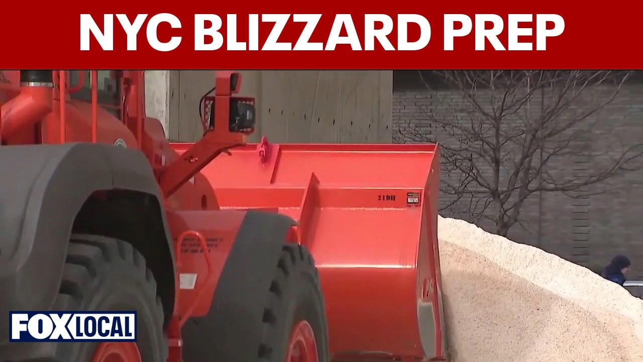
Residents are urged to finalize preparations Saturday, avoid unnecessary travel during peak storm hours and monitor official updates.
Stay ahead of the snow with FOX 5’s expert meteorologists, streaming LIVE on FOX LOCAL. We’re streaming nonstop coverage with the newest forecasts, snow potential, and preparation tips. Download FOX LOCAL for 24/7 weather coverage on your smart TV and mobile devices.
The Source: This article was written using forecast information from the National Weather Service, FOX Weather and FOX 5 NY meteorologists.