

Nor'easter or nothing: Explaining the scenarios for potential major weekend NYC snowstorm
NEW YORK CITY - Forecasters are tracking a potential nor’easter that could bring snow to the New York City area this weekend. However, much of the forecast remains uncertain.
JUMP TO: MODELS l CHANCES OF SNOW | DAILY FORECAST
What we know:
Most of the Interstate 95 corridor is under watch, but meteorologists caution that significant uncertainty remains as weather models offer conflicting scenarios.
Talking possible weekend New York City nor'easter
Forecasters are tracking a potential nor’easter that could bring snow to the New York City area this weekend. However, much of the forecast remains uncertain. FOX 5 NY's Liv Johnson joins Newsroom Live with Dan Bowens to explain.
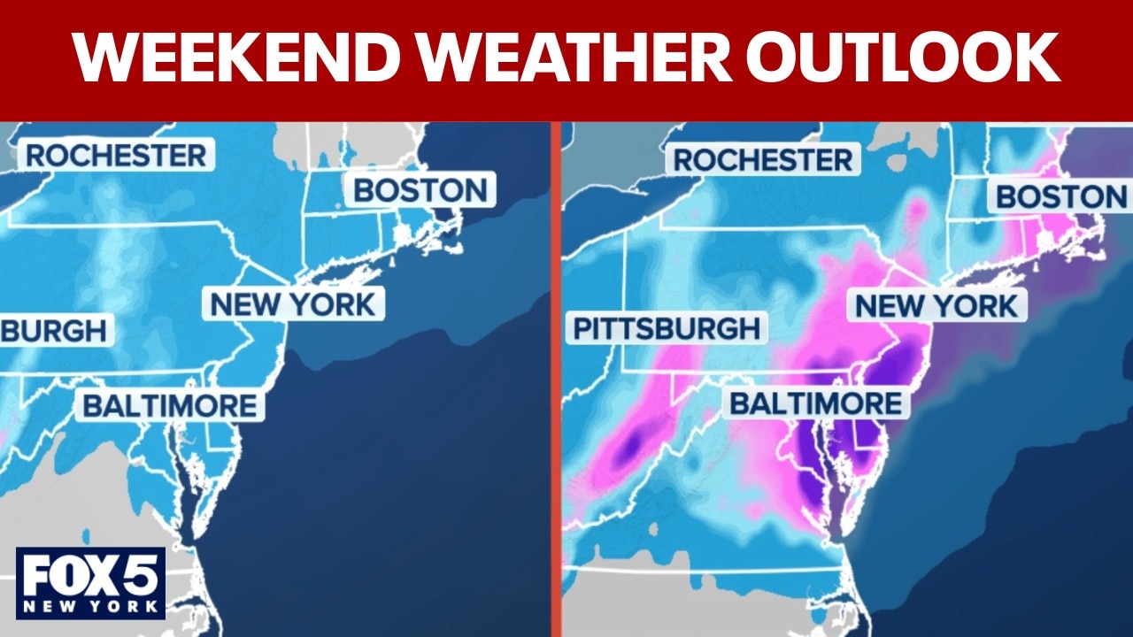
Certain models have been making the rounds on social media showing a major snowstorm. But in reality, that's only one model. At the same time, another model shows snow, but in a lighter form.
What is the American model saying?

What is the European model saying?

Will it snow this weekend?
Dig deeper:
The storm system is currently moving along the coast of Canada. Whether the system strengthens into a powerful coastal storm along the Northeast shoreline, or slides harmlessly out to sea, depends on several factors, including its track and the availability of cold air from Canada.

Potential weekend storm setup. (FOX Weather)
While some snow appears to be the most likely outcome, all scenarios remain on the table, from a complete miss that tracks out to sea, to a major nor’easter, according to the FOX Forecast Center.
Are we getting snow this weekend?
By the numbers:
As of Thursday, the National Weather Service forecasts a 50% chance of snow for New York City on Sunday and Sunday night.

Photo credit: FOX Weather
A 30% chance of precipitation late Saturday could begin as rain before changing to snow as colder air moves in.
How much snow are we getting Sunday?
If snow does fall, current projections suggest only a few inches for the city unless the storm tracks closer to the coast and intensifies. A more offshore track would significantly reduce snowfall totals.
"A coastal low is really what’s going to determine what happens," FOX 5 NY meteorologist Liv Johnson said. "If this low moves closer, that increases our chance of seeing some snowfall. If it stays further offshore, which the models are just not agreeing on right now , then our chances decrease."
What is the weather for today?
- Thursday: On Thursday, skies will remain cloudy with a high near 42 degrees and a northeast wind around 9 mph. Thursday night, rain is likely after 4 a.m. with a low around 37 degrees and a 60% chance of precipitation.
- Friday: On Friday, periods of rain are expected with temperatures holding steady around 39 degrees. The chance of precipitation is 100%, and rainfall totals between a quarter- and half-inch are possible. Friday night brings a 30% chance of rain before 1 a.m. Skies will remain mostly cloudy with temperatures around 42 degrees as winds shift from north to west.
- Saturday: On Saturday, there is a 20% chance of rain after 1 p.m., otherwise partly sunny skies are expected with a high near 46 degrees. Saturday night, rain is possible before 10 p.m., then precipitation could change to snow as colder air moves in. The low will be around 35 degrees with a 30% chance of precipitation.
- Sunday: On Sunday, there is a 50% chance of snow under cloudy skies with a high near 38 degrees. Sunday night, the chance of snow remains at 50% with cloudy conditions and a low around 32 degrees.
Why you should care:
The New York City area is still dealing with lingering snow from January’s historic winter storm, which could compound impacts if a stronger system materializes. Forecasters say confidence in the storm’s track and how much snow, if any, will fall in New York City should improve as the weekend approaches.
About the two models
In the U.S., the two most popular models you'll see mentioned on social media are the Global Forecast System (GFS), also colloquially known as "The American Model", and the model run by the ECMWF, the European Centre for Medium-range Weather Forecasts, colloquially known as "The European" model, or "Euro" for short.
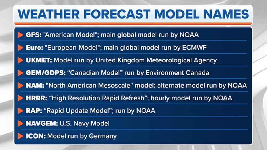
Photo credit: FOX Weather
NOAA runs the GFS with support from several other U.S. research and government entities. The ECMWF is based in England but is a private consortium supported by 34 European countries.
There are different models run by government weather agencies, but the Euro and GFS are the two you'll hear about most often.
NYC weather forecast
Click HERE for more information.
Stay ahead of the snow with FOX 5’s expert meteorologists, streaming LIVE on FOX LOCAL. We’re streaming nonstop coverage with the newest forecasts, snow potential, and preparation tips—before the storm and all weekend long. Download FOX LOCAL for 24/7 weather coverage on your smart TV and mobile devices.
The Source: This report is based on information from FOX Weather, the National Weather Service and FOX 5 NY's Liv Johnson.