

Severe weather alert: NYC faces damaging winds, thunderstorm threat on Tuesday

NEW YORK CITY - Potential severe weather could slam the New York City area this afternoon and evening, bringing along the chance of damaging winds, heavy rain, thunderstorms and even an isolated tornado.
Weather in NYC today
Timeline:
The abundance of warm, humid air will likely lead to some stronger storms:
- Tuesday: A chance of showers and thunderstorms, then showers likely and possibly a thunderstorm after 5 p.m. Some of the storms could be severe. Partly sunny, with a high near 86. Southwest wind 10 to 13 mph. The chance of precipitation is 60%. New rainfall amounts between a tenth and quarter of an inch, except higher amounts possible in thunderstorms.
- Tuesday night: Showers and possibly a thunderstorm, mainly before 5 a.m, then a chance of showers and thunderstorms after 5 a.m. Some of the storms could be severe. Low around 74. Southwest wind 6 to 10 mph. The chance of precipitation is 80%. New rainfall amounts between a quarter and half of an inch possible.
NYC weather hourly forecast
Local perspective:
Most of New Jersey, as well as parts of the New York City area, are under a "slight" risk of severe weather, or a Level 2 out of 5 threat, according to the National Weather Service (NWS).
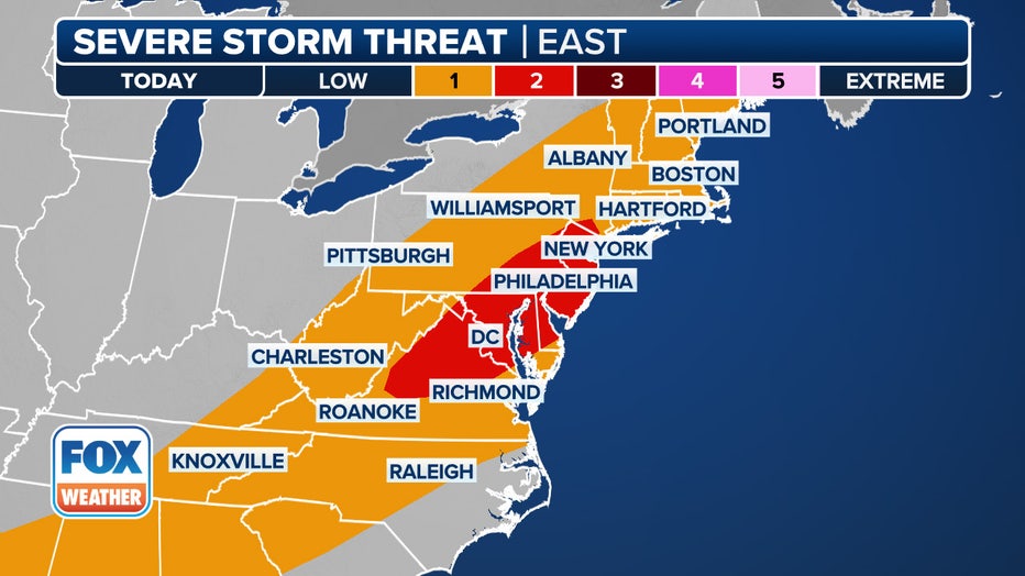
This graphic shows the severe storm threat on Tuesday, July 1, 2025. (FOX Weather)
Damaging wind gusts in excess of 58 mph "could damage trees and power lines and result in power outages," the NWS says. In addition, there will be plenty of low-level moisture associated with the cold front, which could lead to flash flooding. The agency says rainfall rates of 2"/hour is possible.
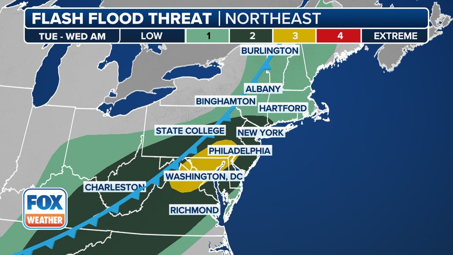
This graphic shows the flash flood threat on Tuesday, July 1, 2025. (FOX Weather)
"Localized instances of flash flooding of urban and poor drainage areas is possible, as well as along quick responding small streams and creaks," they said.
Severe thunderstorm watch
A severe thunderstorm watch has been issued by the NWS for parts of Delaware, Maryland, New Jersey, Pennsylvania, Virginia, West Virginia and Washington D.C.
What could change with the weather?
What we don't know:
The NWS says more cloud covering during the daytime could result in a lower threat of severe weather. But if clouds clear out faster than forecast, the "threat of severe weather will increase."
What they're saying:
"Scattered showers and storms with some heavy rain will start coming through later this evening and into tonight," FOX 5 NY's Mike Woods said. "Expect some flooding later this evening too!"
What's next:
By Wednesday, the cold front will be moving out, and all storm activity will be over for the bulk of the East Coast. The rest of the week looks to have little to no problems.
FOX Weather LIVE updates
Weather radar NYC
Click HERE for more information.