

Severe weather threatens NYC with damaging winds and hail; isolated tornadoes possible

NYC weather forecast: Timing, impacts of possible severe storms
FOX 5 NY's Liv Johnson has the details.
NEW YORK CITY - New York City could see potentially severe weather on Thursday, including damaging winds, heavy rain and scattered thunderstorms, ahead of an expected heat wave next week.
JUMP TO: SEVERE WEATHER THREAT l UPCOMING HEAT WAVE
Featured

Teen struck by lightning in Central Park during severe storm
The teen had reportedly taken shelter under a tree near 101st Street and Fifth Avenue around 3:45 p.m. to avoid the rain.
Warm temperatures and high humidity across the region will set the stage for thunderstorms set to fire this afternoon, threatening the evening commute and air travel with damaging wind gusts of 60 mph.
"Watch out for scattered severe thunderstorms today," FOX 5 NY's Audrey Puente said. "The timing, after about 3 or 4 p.m. until sunset tonight. The primary threat will be damaging wind. However, we could have rounds of heavy rainfall, quick downpours. Also, small hail and isolated tornadoes can be possible within some of these storms."
Here's what you need to know about the chance for severe weather in New York City, as well as a look at next week's potential heat wave.
Featured

NYC weather forecast for the longest day of the year, first day of summer
A heat dome will cause temperatures in New York City and the tri-state area to climb into the upper 90s, with high humidity making it feel even hotter.
Weather in NYC today: What's new?
What we know:
"The risk for severe thunderstorms this afternoon has increased for northeastern NJ, Lower Hudson Valley, NYC and southwestern CT," the National Weather Service (NWS) said. "On average we may only see an enhanced risk day once or twice a year."
NWS severe weather outlook
Timeline:
Parts of the Tri-State area, including most of New York City, Long Island and Connecticut, are under a "slight risk" for severe weather. The category is defined by the NWS as "increased confidence that some storms will contain damaging winds, severe hail, and/or tornado potential."
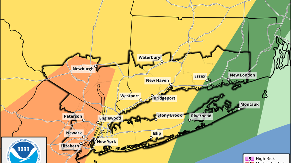
Severe weather outlook. (NWS)
Meanwhile, most of New Jersey is under an "enhanced risk" for severe weather. That category is defined as "high confidence that several storms will contain damaging winds, severe hail, and/or tornadoes."
- Thursday: A 30% chance of showers and thunderstorms, mainly after 5 p.m. Some of the storms could be severe. Mostly sunny, with a high near 86. The NWS says the enhanced severe thunderstorm threat falls between 2 p.m. and 10 p.m., but isolated and scattered storms are possible as early as 1 p.m.
- Thursday night: A 30% chance of showers and thunderstorms before 2 a.m. Some of the storms could be severe. Cloudy during the early evening, then gradual clearing, with a low around 70.
- Friday: Sunny, with a high near 81. Storms are expected to clear by the morning.
Local perspective:
The main threats from the storms will be damaging wind gusts in excess of 58mph, scattered thunderstorms and heavy rainfall, which could cause minor flooding in certain areas.
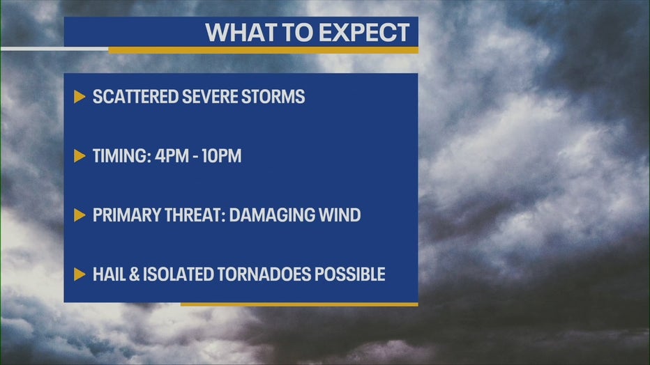
"More organized scattered to numerous severe thunderstorm threat, including bowing lines of thunderstorms and/or multicell clusters possible between 4 and 10 p.m.," the NWS said.
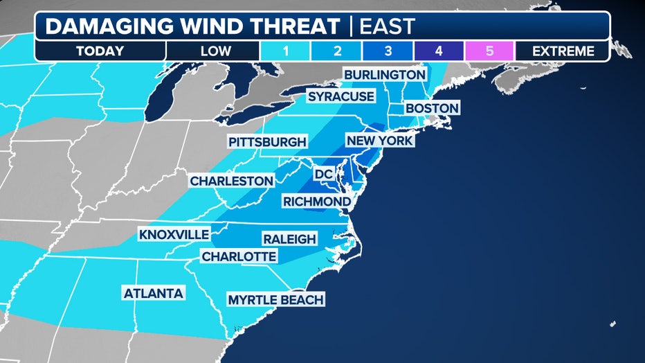
This graphic shows the threat of damaging wind gusts on Thursday, June 19, 2025. (FOX Weather)
Localized large hail and flash flood threats are also possible, as well as an isolated tornado.
Severe thunderstorm watch
The NWS has issued a severe thunderstorm watch for parts of the Tri-State area until 9 p.m.
Weather next week: Heat wave NYC
What's next:
The prime time for a potential heat wave next week will be from Sunday through Thursday. While relatively few locations may actually hit the 100-degree mark, the combination of high temperatures and elevated humidity levels will make it feel significantly hotter.
- Sunday: Partly sunny, with a high near 86.
- Monday: Sunny, with a high near 88.
- Tuesday: Sunny, with a high near 90.
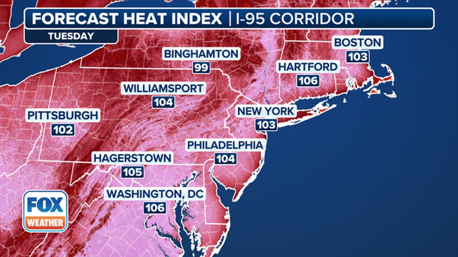
This graphic shows the forecast heat index on Tuesday, June 24, 2025. (FOX Weather)
- Wednesday: Sunny, with a high near 88.
New York City has only reached the 100-degree threshold three times during the month of June. The NWS is expected to issue a range of heat-related alerts in the coming days, which may include heat advisories, extreme heat watches and extreme heat warnings, depending on the expected severity and duration of local conditions.
FOX Weather LIVE updates
NYC weather radar
Click HERE for more information.