

NYC flood updates: Transit, roads shut down during rush hour | Timeline
NEW YORK - Slow-moving thunderstorms that made their way through the New York City area were likely to "pose threats to life and cause significant disruptions" as rain falls as fast as 2 to 3 inches per hour, according to the National Weather Service.
Cross Island Parkway experiencing closures
6:30 p.m.: The southbound lanes of the Cross Island Parkway are blocked from Throggs Neck to Northern Boulevard.
Mayor issues state of emergency
5:30 p.m.: Mayor Eric Adams said Thursday evening issued an emergency declaration.
"I’ve issued a state of emergency," he said. "The Travel Advisory and Flood Watch are in effect until 8 AM. Stay where you are if you can. Don’t drive. Roadways are flooding, and crews are responding. If you live in a basement apartment, and haven’t yet moved to higher ground, move now."
Port Washington line of LIRR canceled in both directions
5:20 p.m.: The entire Port Washington line of the LIRR is canceled in both directions due to flooding in Flushing, Queens.
"Service is suspended in both directions on the Port Washington Branch due to flooding east of Flushing Main Street caused by today's storm," MTA wrote.
Alternate side parking suspended
5:15 p.m.: Alternate side parking regulations will be suspended on Friday, August 1, to facilitate weather operations. Parking meters will remain in effect, according to NYC Alt Side Parking.
Early official rain totals
5:10 p.m.: The city's Office of Emergency Management released early and unofficial rainfall numbers from Thursday's evening storms via NYC Micronet stations.
According to the agency, some on Staten Island may have seen almost 2 inches of rain. Other areas saw more than an inch.
NYC airport delays
4:45 p.m.: Each of the NYC-area airports was dealing with departure delays due to the weather. Here are the most recent delays according to the Federal Aviation Administration.
Newark:
- Departure delays up to 15 mins
JFK:
- Departure delays of up to 95 mins
LaGuardia:
- Departure delays of up to 90 mins
LIRR delays
4:28 p.m.: Service is suspended in both directions on the Port Washington Branch due to high water east of Flushing Main Street.
NJ Transit service
4:25 p.m.: NJ Transit says:
- Gladstone Branch rail service is suspended in both directions between Bernardsville and Gladstone due to weather related overhead power issues.
- River Line service is suspended in both directions between the Waterfront Entertainment Center and Walter Rand Transportation Center due to flooding conditions in Camden. Substitute bus service is being provided.
MTA train delays
4:23 p.m.: The weather is causing issues for train service across the city. The MTA says service is suspended on the C and B trains, and part of the M.
Riders on the A, E, D, and F trains will encounter severe delays.
LINK: Latest from the MTA
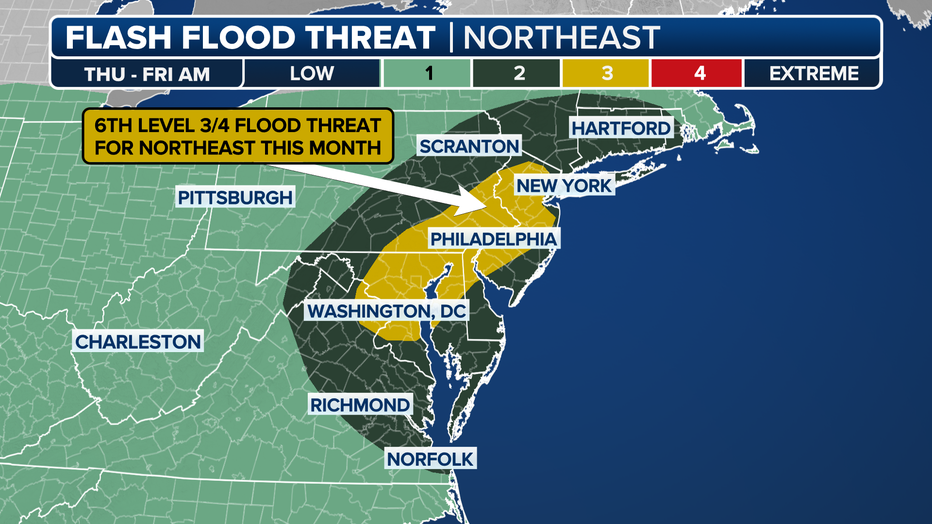
Flash Flood Warning in effect
4:15 p.m.: A Flash Flood Warning remains in effect for most of the region. Specific locations named in the latest NWS alert include:
- Central Nassau County in southeastern New York
- Southern Bergen County in northeastern New Jersey
- Hudson County in northeastern New Jersey
- Kings (Brooklyn) County in southeastern New York
- New York (Manhattan) County in southeastern New York
- Richmond (Staten Island) County in southeastern New York
LINK: See the live list of weather alerts here
First responders on scene
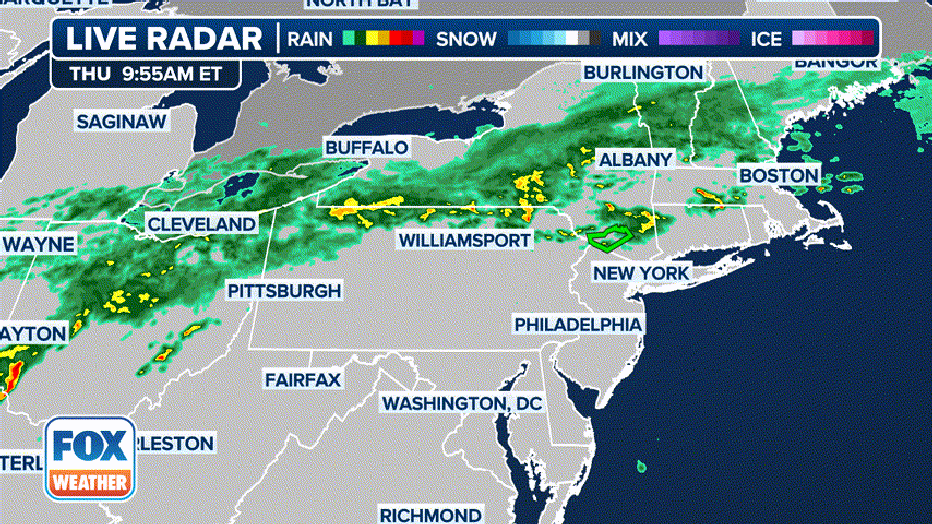
4:10 p.m.: Parts of the Northeast are experiencing heavy rainfall today, as some roadways in New York City are flooded due to the wet weather. Footage shows a first responder checking in on a car stuck in the water on the Clearview Expressway in Queens.
Flooding in Queens
3:45 p.m. Flooding on the Clearview Expressway in Queens, New York, between Northern Boulevard and 35th Avenue.

Flash flooding on the Clearview Expressway in Queens
Flooding on the Clearview Expressway in Queens, New York, between Northern Boulevard and 35th Avenue on July 31, 2025. Courtesy: Citizen App
NYC weather forecast
Flash Flood Warnings and Severe Thunderstorm Warnings were issued for NYC and parts of New Jersey as some localized areas could see up to 2 to 5 inches of rain in as little as 3 to 6 hours. New Jersey and New York issued states of emergency due to flash flooding threats.
Already, 2 to 3 inches of rain fell in northwestern New Jersey in just one hour, according to the NWS.
Here’s a look at the timeline for today’s storms, expected rainfall totals and threats. You can also watch live coverage of the storm below:
Timeline
The Flood Watch began at 2 p.m., and FOX 5 NY meteorologist Mike Woods says storms will hit the area around 2 to 3 p.m. These storms are expected to develop quickly due to surface heating and dew points in the 70s, according to FOX Weather.
Flash flooding risks are expected to rise in the afternoon as storms develop, with New York City Mayor Eric Adams advising residents to prepare and avoid travel.
Torrential rain, enhanced by a slow-moving cold front and low pressure, could reach rates of up to 3 inches per hour.
"It is difficult to pinpoint exactly where the most intense rainfall rates and repeating storms will happen," the NWS stated.
Most of these storms are expected to develop in clusters, but there is a possibility that dangerous supercell thunderstorms --which cause tornadoes -- develop, according to FOX Weather.
Downpours should end by midnight, according to the NWS, but light to moderate rainfall may persist into the early morning hours of Tuesday.
The NWS Flood Watch ends at 8 a.m. Friday.
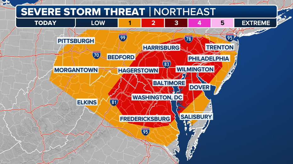
Which areas face the biggest storm dangers?
The entire New York City Tri-State faces threats from these storms, especially from flash flooding but also from damaging wind gusts over 60 mph and large hail.
According to the NWS, the area faces a 25-40% chance of flash flooding with a 5% chance of severe flooding, posing threats to life, transportation disruptions and potential water rescues.
Urban areas with poor drainage face an elevated risk along with low-lying areas.
NOAA’s Storm Prediction Center (SPC) placed parts of New Jersey in a Level 2 risk on its 5-point severe thunderstorm risk scale.
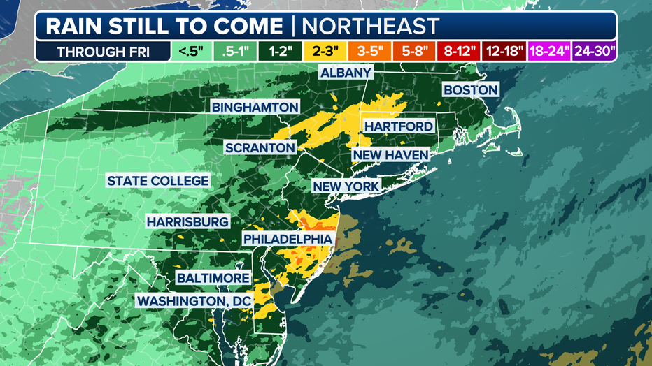
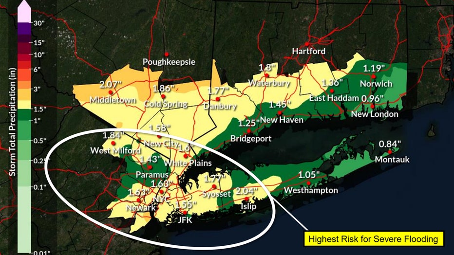
Expected rainfall totals
Rainfall totals are expected to be 2 to 4 inches in many areas, with localized amounts of 5 to 8 inches possible. Again, the majority of the rain will fall in a very short window of three to six hours.
The map below from NWS shows expected rain totals:
Watch live weather coverage
FOX 5 NY will have a live weather update on our YouTube page.
You can also watch realtime coverage from the FOX Weather team here:
The Source: This article uses reporting from the National Weather Service, FOX Weather and FOX 5 NY meteorologists.