

NYC forecast: How much snow to expect Friday, when bitter cold weather ends

NEW YORK - Click here for our latest snow forecast for tomorrow.
Winter is giving NYC its very best – or very worst – as the weather forecast shows another round of measurable snow coming Friday, followed by bitter cold temperatures as an Arctic air mass infiltrates the area this weekend.
JUMP TO: SCHOOL CLOSINGS | LIVE RADAR | WEATHER TIMELINE | SNOWFALL PREDICTIONS | WEEKEND COLD
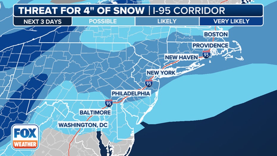
The probability of 4 inches of snow along the I-95 corridor. (FOX Weather)
New York feels out of practice with this level of winter weather – after weeks of mild temperatures and a nearly two-year snowless streak, NYC was hit with more than an inch of snow and frigid temperatures. And that was just Monday through Wednesday!
Here's what to expect Friday and into the weekend.
Timeline: When will NYC see snow?
Thursday: Expect cloudy skies throughout the day – and maybe a snow shower or two north of the city. Temperatures will linger around the freezing mark.
Early Friday morning: A winter weather advisory will be in effect for parts of New Jersey at midnight. So far, New York City is not included in the advisory.
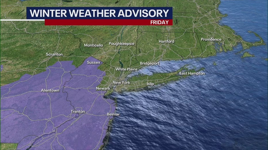
Winter weather advisory for most of New Jersey.
Shortly after, a low-pressure system is expected to bring light snow, falling at a rate of about 0.5 inches per hour. The city could start seeing flurries as early as 6 a.m., according to the National Weather Service.
"It’s a little bit of a dusting," FOX Weather Meteorologist Britta Merwin said. "The difference this go-around is that we’ve had a lot of cold air in place ahead. And that could make for more fluffy snow."
Friday afternoon: Temperatures are forecast to stay around the 30-degree mark as light snow continues to fall. Peak impacts will be from 10 a.m. - 4 p.m.
"It's going to be a similar event to what we had [Tuesday], only I don't think we're going to see the freezing-rain situation," FOX 5 NY's Nick Gregory said.
Commuters should expect impacts on evening travel, as snow will cover roads and visibility will be reduced.
The snowfall will stop at night, and the winter weather advisory ends.
Temperatures will dip Friday night, with wind chills close to zero! It will feel like 7 degrees at times in New York City.
How many inches of new snow will fall?
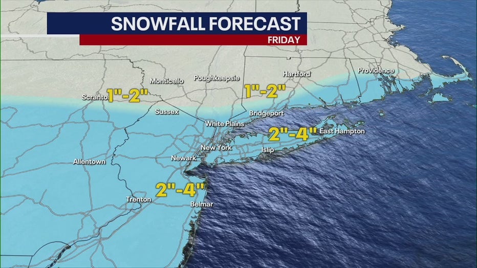
By late Friday, New York City is expected to see 2 to 4 inches of snow, with a worst-case scenario of up to 5 inches.
"In terms of the probability of at least 2 inches of snow, it’s very likely from Pennsylvania, New Jersey and parts of New York," FOX Weather Meteorologist Britta Merwin said. "We’re going to see lower snow totals for New England with this batch. So, this is really going to be favoring New York City down towards D.C. and then pushing father out to the west."
The South Shore of Long Island and coastal New Jersey could see slightly more accumulation.
If the storm tracks farther from the coast, there is a chance the area could see little or no accumulation.
Inversely, a closer track than expected could result in totals as high as 5 inches throughout NYC, Long Island, the upper New York counties and Connecticut.
High-end amounts for snowfall Friday (National Weather Service)
Weekend weather: Arctic air mass bringing bitter chill
The frigid winter air has enveloped much of the U.S., affecting millions of Americans with its bone-chilling grasp from border to border.
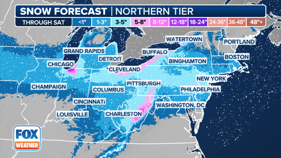
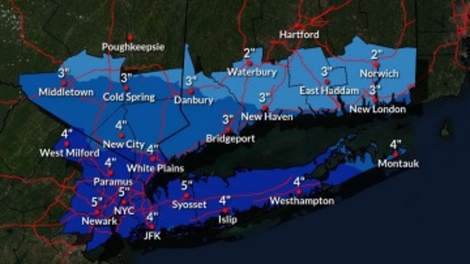
Forecast snow totals in the Northeast through Saturday, Jan. 20, 2024. (FOX Weather)
Sub-freezing temperatures will continue through the weekend, with wind chill values near zero beginning Friday night.
Saturday and Sunday morning will see temperatures in the teens, but the blustery winds will make it feel like the single digits.
Saturday night's wind chill
Afternoon temperatures will reach the upper 20s and low 30s.
By next week, NYC should finally see some relief. Temperatures finally scoot above the freezing mark by Monday and reach as high as the 40s on Tuesday.
When will the cold snap end?
While warmer weather is on the horizon, it could be at least a week before temperatures return to average or warmer.
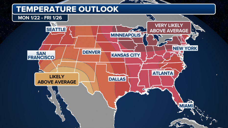
A look at the temperature outlook through Jan. 26, 2024. (FOX Weather)
According to the long-range temperature outlook from NOAA's Climate Prediction Center, next week will likely feature above-average temperatures for late January across much of the U.S.
"We are going to have our own natural heater come next week, thankfully. Across the country, the entire Lower 48 expects to be above average in spots that were well below," said FOX Weather Meteorologist Jane Minar.
New York City end record snowless streak
It’s been nearly two years, but record snowless streaks have finally ended after more than 700 days in New York City when a winter storm dumped snow across the region.

The National Weather Service says Central Park picked up 0.4 inches of snow on Monday, followed by 1.2 inches of snow falling between midnight and 1 p.m. Tuesday, bringing the storm total to 1.6 inches of snow.
Central Park is the official measuring site for New York City.
FOX Weather helped contribute to this report.