

NJ tornado warning; NYC braced for soggy week

Severe storms, flooding threatens NYC area
A severe thunderstorm watch is in effect through 8 p.m. for areas west of New York City as a flash flood warning has been issued for parts of northeastern Pennsylvania, northern New Jersey, much of New York and large portions of New England.
NEW YORK - New York City and much of the Northeast are stuck in a rainy pattern this week, with forecasters warning of flash flooding, thunderstorms, and rising river levels. Also, severe thunderstorms capable of producing a tornado have led to a tornado warning for parts of Sussex and Warren counties in New Jersey.
If you are in shelter, move to a basement or interior room, and avoid windows. If you are outdoors or in a vehicle, move to the closest shelter to protect yourself from debris.
The warning is in effect until 5:15 pm.
What we know:
The National Weather Service is forecasting several rounds of rain and thunderstorms across New York City through Friday. The wet weather is part of a larger low-pressure system stalled over the Tennessee and Ohio valleys, funneling Atlantic moisture into the Northeast.
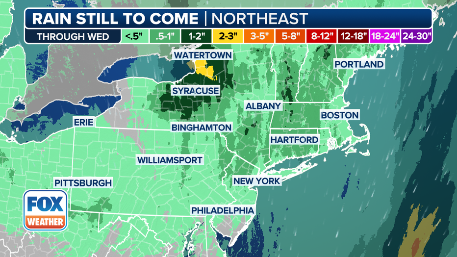
Parts of the region—including northeastern Pennsylvania, northern New Jersey, much of New York, and large portions of New England—are under a Level 1 flash flood threat.

Credit: National Weather Service
A separate Level 2 severe thunderstorm risk has been issued for areas including Binghamton, Scranton, Allentown, and the Philadelphia suburbs, where damaging winds and hail are possible.
Flood Watches have been posted for parts of New York’s Hudson Valley, northern Connecticut, and western and central Massachusetts.
Timeline:
Here's a day-by-day breakdown of the forecast:
Tuesday afternoon:
Showers likely, possibly with thunderstorms. Patchy fog. Cloudy, with a high near 67. Southeast wind around 10 mph. Chance of precipitation is 70%. Most areas will receive less than a tenth of an inch of rain, but heavier amounts are possible in thunderstorms.
Tuesday night:
Showers and thunderstorms likely before 8 p.m., with chances continuing through 2 a.m., then showers lingering after 2 a.m. Patchy fog overnight. Low around 57. South wind 3 to 8 m.p.h. Chance of rain is 60%.
Wednesday:
Chance of showers and possible thunderstorms after 11 a.m. Fog may linger early. Gradual clearing expected later in the day. High near 72. Southwest wind 5 to 9 mph. Rain chance is 50%.
Wednesday night:
Partly cloudy, with a low around 58. West wind around 6 mph.
Thursday:
Partly sunny, with a 30% chance of showers and thunderstorms after 2 p.m. High near 73.
Thursday night:
Rain likely after 8 p.m. Low around 53. Chance of precipitation is 70%. Up to half an inch of rain possible.
Friday:
Rain likely. Mostly cloudy, with a high near 60. Rain chances remain at 70%.
Weekend outlook:
Saturday is expected to be mostly sunny, with a high near 71. Sunday will be warmer and mostly sunny, with highs in the mid-70s.
What's next:
This storm system is expected to move out of the region by Wednesday afternoon, offering a short break in precipitation. However, forecasters warn that another disturbance could bring another round of rain to the Northeast by Friday, prolonging flood risks and travel delays.
Showers could also affect several MLB games Tuesday night, including the Yankees hosting the Padres in the Bronx and the Red Sox playing the Rangers in Boston.