

NYC mid-winter weather forecast: Expect much more snow this season
NEW YORK - FOX 5 NY meteorologist Nick Gregory has reason to believe that six more weeks of winter are upon us, especially since the mid-range weather forecast shows a major snow storm or two could be headed our way in the coming weeks.
In his 2024 mid-winter weather outlook, Nick breaks down what to expect for the rest of winter -- including when we'll likely see snow storms, how many more inches of snow we'll record and what the beginning of spring has in store.
He covers:
- Should the New York City area expect "six more weeks of winter" or "early spring"?
- How much snow can we expect for the remainder of the winter?
- When is the first day of spring? What's Nick's spring 2024 outlook?
- How accurate is Punxsutawney Phil?
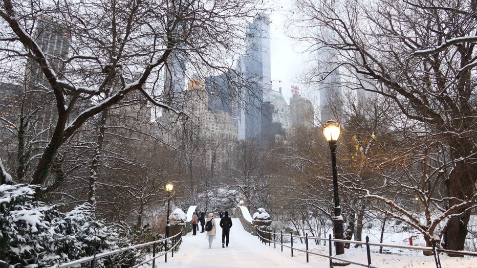
People walk over the Gapstow Bridge as snow falls in Central Park on January 16, 2024 in New York City. The City received a rare accumulation of snow overnight. (Photo by Gary Hershorn/Getty Images)
Should NYC expect "six more weeks of winter" or "early spring"?
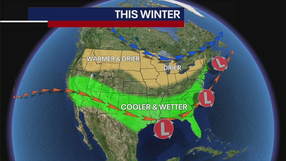
Punxsutawney Phil predicts an early spring for NYC, but as Nick had told us in his original winter weather outlook, the U.S. is experiencing a strong El Niño, meaning the Tri-State is more likely to see warmer-than-average temperatures and wetter-than-average precipitation.
What is El Niño?
When choosing ingredients to make a long-range forecast, we need to look at weather patterns around the world. It's also important to look at what’s happened in the past to see if we can apply that to the future.
One of the main ingredients is the El Niño-Southern Oscillation, OR ENSO. South American fishermen first noticed periods of unusually warm water in the Pacific Ocean back in the 1600s and gave it the name El Niño, or "little boy."
In today’s modern world, when above-average sea surface temperatures occur in the eastern Pacific Ocean, it’s known as an El Niño phase.
How is the Pacific Ocean affecting NYC?
These warmer sea surface temperatures strengthen the southern jet stream, allowing more moisture to be transported to our part of the world, according to the National Weather Service.
So far, the southern jet stream has dumped some wild weather on the South before working its way up the East Coast toward us. We've seen several rain-snow events, some with temperatures osculating above freezing and below freezing, creating a rain-snow divide between the coast and inland.
Nick's prediction
As we move forward, strong El Niño conditions will continue, meaning February will feature the same type of weather we've seen: above-average temperatures and borderline rain-snow events.
"I think winter will be prolonged here, and I do think that we'll probably have a good surge of cold weather coming in the middle part of February, [creating the potential for a snow storm or two," Nick said.
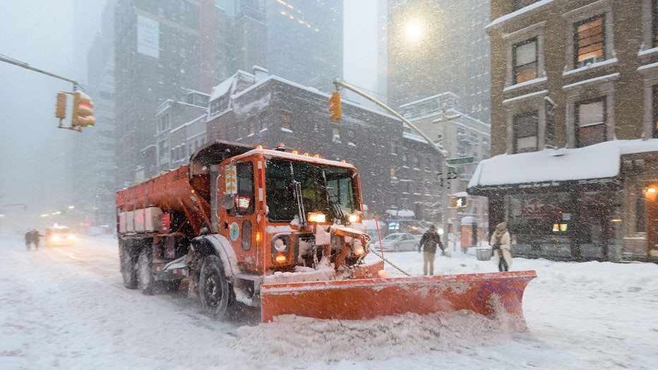
A snowplow clears snow on Lexington Avenue during the snowstorm January 2016 in New York. (Photo by FRANCOIS XAVIER MARIT/AFP via Getty Images)
How much snow can we expect for the remainder of the winter?
New York City's Central Park has recorded a measly 2.3 inches of snow this winter – but hey, at least we're no longer in a snow drought!
And that's approximately the total amount of snow NYC saw in the 2022-2023 season, well below the seasonal average of 29 inches.
By February, NYC normally records about 14 inches of snow, so we're still a little behind. But snow lovers – Nick's got news for you.
"I'm thinking there's still the potential for at least another 15 inches of snow around here," Nick forecasts. And we'll likely see even higher totals inland.
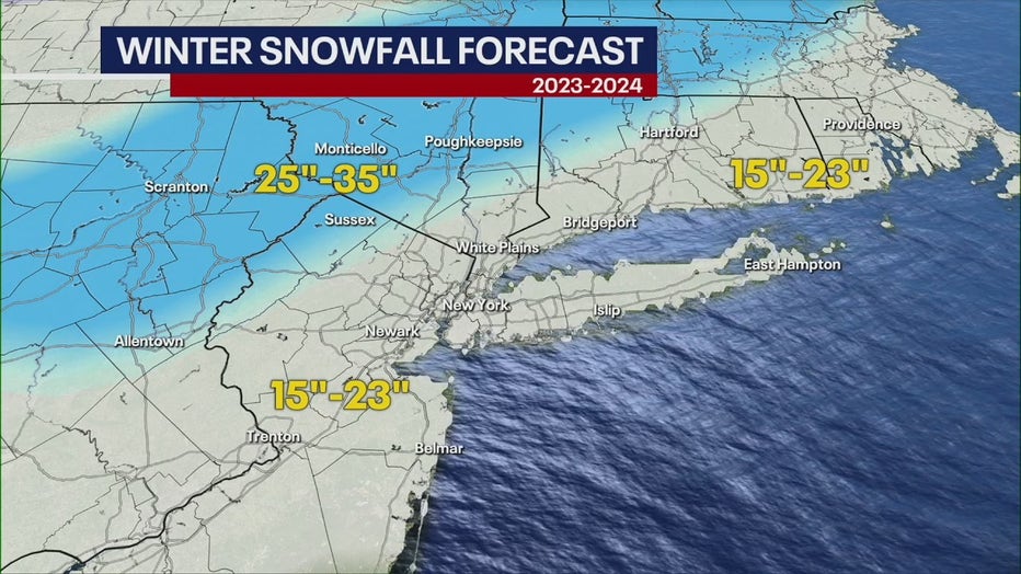
Only one or two decent snow storms will help us reach this projected total, he said.
Nick predicts that February's conditions paired with the strong El Niño are the perfect recipe for this kind of perfect storm.
What about those warmer temperatures? What can we expect?
These are the normal temperatures for February and March, so expect, on average, a bit more heat.
February
- Average high: 42.2 degrees
- Average low: 29.5 degrees
March
- Average high: 49.9 degrees
- Average low: 35.8 degrees
When is the first day of spring? What's Nick's spring 2024 outlook?
Spring officially begins on March 19 at 11:06 p.m.
Despite the change in season, don't expect springlike temps any time soon: The first 60-degree day of the year usually lands on April 10 for us. (Fingers crossed we see one sooner than that!)
Also, our friend El Niño is sticking around. It's going to start weakening as we enter the April-May time frame but should still lead to warmer-than-average temperatures, Nick forecasts.
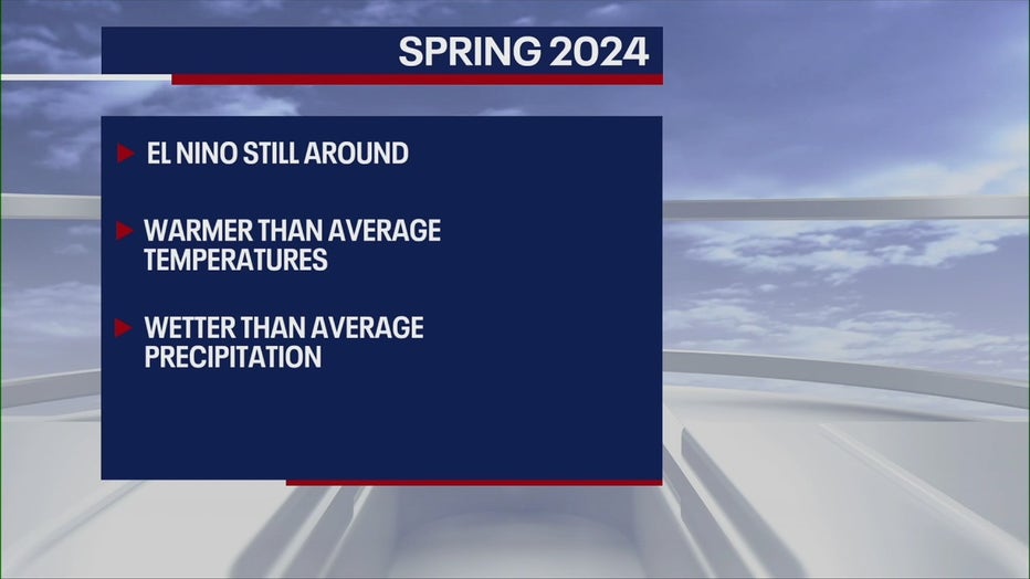
"We'll still have cool snaps here and there, and it looks like we'll still have wetter-than-average precipitation," he said.
We shall see if the groundhog is right or wrong. Certainly, we'll have six more weeks to find out.
How accurate is Punxsutawney Phil?
Legend has it that if Punxsutawney Phil sees his shadow from Gobbler’s Knob, six more weeks of winter weather are ahead. If not, spring will arrive early.
The animal prognosticator has been at it since the 1880s. Records kept by the Punxsutawney Groundhog Club show Phil has predicted 108 continued winters and only 20 early springs as of 2024. According to the Stormfax Almanac, that works out to a 39% accuracy rate for Phil.
Groundhog handler AJ Derume and Punxsutawney Phil, who saw his shadow, predicting a late spring during the 137th annual Groundhog Day festivities on February 2, 2023 in Punxsutawney, Pennsylvania. (Photo by Michael Swensen/Getty Images)
In the near term, the groundhog’s accuracy rate is slightly better. According to the NOAA's National Centers for Environmental Information, Phil has been right about 40% of the time over the past decade.
FOX Weather contributed to this report.