

How much snow is coming our way? New forecast as Winter Weather Advisory covers NYC, NJ, Long Island
NEW YORK - A Winter Weather Advisory was issued for NYC, Long Island, parts of New Jersey and Westchester County for tomorrow as snow and frigid cold temperatures will create hazardous travel conditions, especially during the evening commute. Some local school districts have already announced closings and early dismissals in anticipation.

JUMP TO: SCHOOL CLOSINGS | LIVE RADAR | SNOW TIMELINE | PROJECTED SNOW TOTALS
Here's when the New York City area can expect snow, when conditions will be the worst, and how many inches we'll see by Saturday.
Weather forecast: When will NY, NJ, CT see snow?
Thursday night: Skies will remain cloudy and temperatures will dip down to a chilly 28 degrees in the city.
Friday morning: A light, dry snow develops southwest to northeast between 6 a.m. and 10 a.m., initially falling at a rate of 0.25 inches per hour. New Jersey and the western Lower Hudson Valley will see the snow first, around 7 a.m., while flurries will start to pile up in NYC and Long Island around 10 a.m. Temperatures will remain in the low- to mid- 20s, perfect conditions for snow to stick and accumulate.

Friday afternoon: Between noon and 7 p.m., the snowfall begins to accelerate, at about 0.5 inches per hour, according to the National Weather Service. Temperatures may reach 30 at its highest. The snowfall will create low visibility for the evening commute.
Friday evening: Snow is expected to ease out starting at 6 p.m. in most of the area, though it could continue to fall as late as 8 p.m. on parts of Long Island, according to the NWS.
Temperatures will sink into the bitterly cold low teens, with wind chills in the lower single digits.
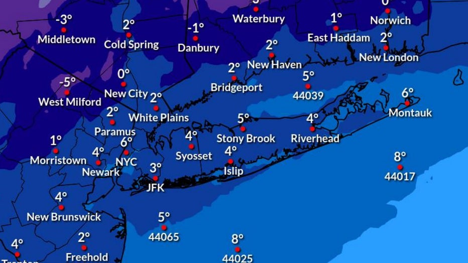
Wind chills Friday night (National Weather Service)
If left untreated, the snow and the freeze will create dangerous, icy conditions on roadways.
How many inches of snow will fall?
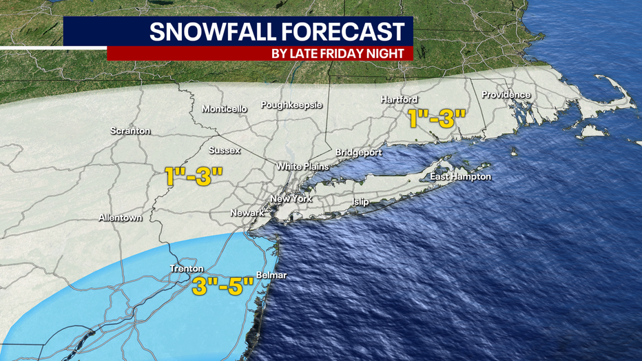
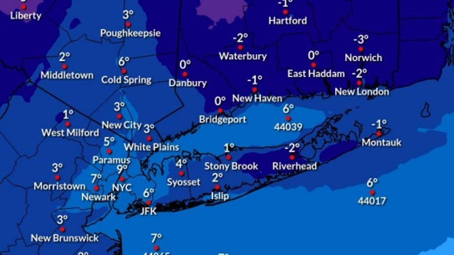
New York City could see anywhere from 1 to 3 inches, according to FOX 5 NY's Nick Gregory, Less snow is expected to the north, and higher amounts are expected for central and southern New Jersey.
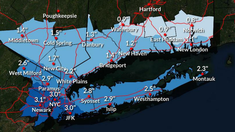
Expected snow totals in the NYC area for Friday (National Weather Service)
National Weather Service forecasters expect 3 inches of snowfall in New York City. On the higher end, New York City, Long Island and most of northern New Jersey could see 5 inches of snow, the NWS predicts. Forecasters say NYC will see two inches if low pressure tracks farther south.
Coastal New Jersey will likely see the most snow in our area, where 4 to 6 inches is forecast.
What areas could see 6 inches of snow?
Winter Storm Warnings were issued for parts of New Jersey that could see up to 6 inches of snow.
This includes Monmouth County near the coast, home to Freehold and Sandy Hook.
Several South Jersey counties, like Burlington, Camden, Gloucester and Salem, could also see these high totals. The National Weather Service also expects the northern and central counties of Sussex, Warren, Morris, Hunterdon, Somerset, Middlesex and Mercer to see 3 to 5 inches.
Weekend weather: Arctic air mass brings bitter chill
The frigid winter air has enveloped much of the U.S., affecting millions of Americans with its bone-chilling grasp from border to border.
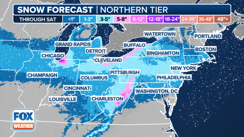
Forecast snow totals in the Northeast through Saturday, Jan. 20, 2024. (FOX Weather)
Sub-freezing temperatures will continue through the weekend, with wind chill values near zero beginning Friday night.
Saturday and Sunday morning will see temperatures in the teens, but the blustery winds will make it feel like the single digits.
Saturday night's wind chill
Afternoon temperatures will reach the upper 20s and low 30s.
When will the cold snap end?
By next week, NYC should finally see some relief. Temperatures finally scoot above the freezing mark by Monday and reach as high as the 40s on Tuesday.
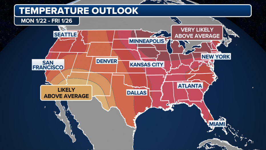
A look at the temperature outlook through Jan. 26, 2024. (FOX Weather)
According to the long-range temperature outlook from NOAA's Climate Prediction Center, next week will likely feature above-average temperatures for late January across much of the U.S.
"We are going to have our own natural heater come next week, thankfully. Across the country, the entire Lower 48 expects to be above average in spots that were well below," said FOX Weather Meteorologist Jane Minar.
New York City end record snowless streak
It’s been nearly two years, but record snowless streaks have finally ended after more than 700 days in New York City when a winter storm dumped snow across the region.

The National Weather Service says Central Park picked up 0.4 inches of snow on Monday, followed by 1.2 inches of snow falling between midnight and 1 p.m. Tuesday, bringing the storm total to 1.6 inches of snow.
Central Park is the official measuring site for New York City.
FOX Weather helped contribute to this report.