

Blizzard or bust? Breaking down the scenarios for a major NYC area snowstorm this weekend

Could NYC see a major snowstorm this weekend?
FOX 5 NY's Mike Woods joins Dan Bowens on Newsroom Live to discuss the potential for a major snowstorm this week in the New York City area,
NEW YORK CITY - Forecast models showing a major snowstorm hitting the New York City area this weekend have been making the rounds on social media, and according to the National Weather Service, confidence in an impactful winter storm this weekend "is increasing."
JUMP TO: MODELS l TIMELINE l IMPACTS l UNCERTAINTY l LIVE UPDATES
But in reality, that's only one model. At the same time, another model shows snow, but in a lighter form.
What is the European model saying?

European forecast model. (FOX Weather)
The European model shows heavy snow blanketing much of the central and eastern portions of the country, including the New York City area.
What is the American model saying?

American GFS forecast model. (FOX Weather)
The American model is similar in ways, but the New York City area is under a blue shade – or moderate potential for snow.
What is FOX 5 NY's Mike Woods saying?
What they're saying:
"This one is probably going to be one of the overachievers. I mean, some of the models give us as much as a foot of snow just to our south," Woods said.
Are we getting snow this weekend?
Timeline:
The National Weather Service (NWS) says snow appears most likely Saturday night through Sunday:
- Saturday night: A 40% chance of snow. Mostly cloudy, with a low around 14.
- Sunday: Snow likely. Mostly cloudy and cold, with a high near 20. The chance of precipitation is 60%.
- Sunday night: A 40% chance of snow. Mostly cloudy, with a low around 15.
How much snow is expected on Sunday?
Local perspective:
According to the NWS, the winter storm will produce heavy snow, sleet and freezing rain over much of the United States before shifting toward the East Coast through Sunday.
As of Tuesday morning, the NWS has parts of the NYC area at a 40% chance of "at least moderate winter impacts." The city is also at a 43% chance of 5 inches of snow or more this weekend.
Snow prediction for this weekend
What we don't know:
"Uncertainty remains regarding the location and magnitude of this winter storm's various components," the NWS said in a post on Facebook.
Specific details regarding timing, amounts and extent of impacts will become more clear as the week progresses.
About the two models
Dig deeper:
In the U.S., the two most popular models you'll see mentioned on social media are the Global Forecast System (GFS), also colloquially known as "The American Model", and the model run by the ECMWF, the European Centre for Medium-range Weather Forecasts, colloquially known as "The European" model, or "Euro" for short.
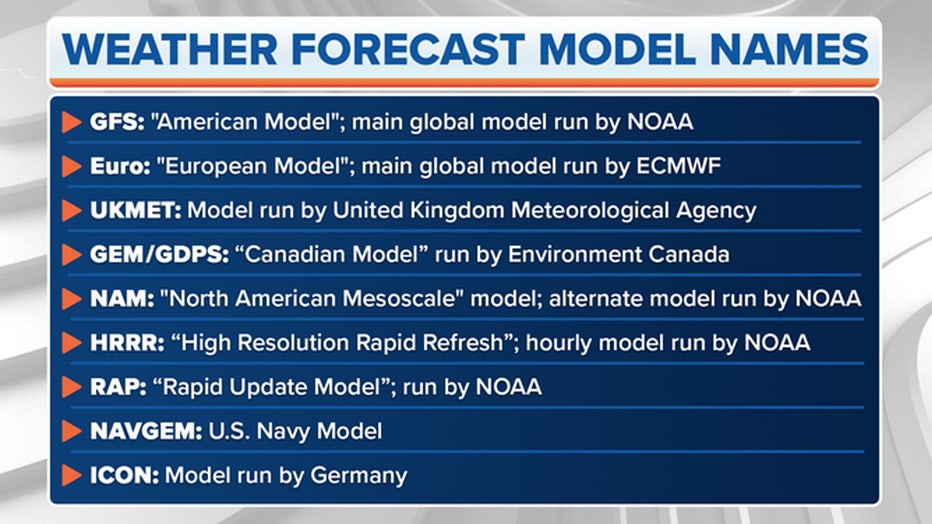
Photo credit: FOX Weather
The National Oceanic and Atmospheric Administration runs the GFS with support from several other U.S. research and government entities. The ECMWF is based in England but is a private consortium supported by 34 European countries.
There are different models run by government weather agencies, but the Euro and GFS are the two you'll hear about most often.
FOX Weather updates
NYC weather radar
Click HERE for more information.