

Weekend winter storm to impact NYC, NJ with snow, rain, ice: Timing, how much to expect

NEW YORK CITY - A winter storm system is expected to bring a mix of snow, rain and ice to the New York City area this weekend, resulting in several inches of snow for parts of New York, New Jersey and Connecticut.
SATURDAY SNOW STORM: TIMING l TOTALS l WHAT'S NEXT
A Winter Weather Advisory is in effect for the Lower Hudson Valley, interior northeastern New Jersey, and southern Connecticut for Saturday afternoon until early Sunday morning.
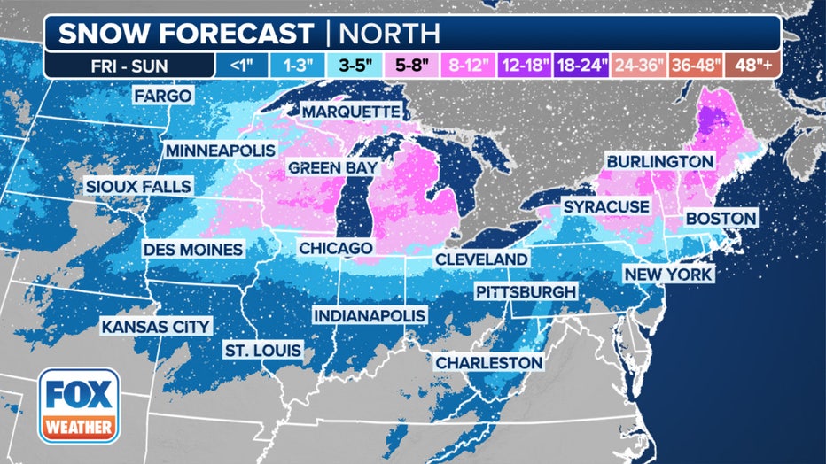
Here's a look at the snow forecast in the North this weekend. (FOX Weather)
Here's a look at the weather forecast timeline and projected snow totals for this weekend.
When will it snow Saturday?
Timeline:
After crossing the Rockies on Friday, the storm is expected to quickly gather moisture from the Gulf and the Atlantic as it moves along.
Snow will start on Friday in parts of the northern and central Plains, spreading eastward across the Upper Midwest on Friday night and Saturday, and reaching the Northeast from Saturday to Saturday night.
For the Lower Hudson Valley, interior northeastern New Jersey, and southern Connecticut, snow will develop on Saturday afternoon and briefly mix with sleet, followed by freezing rain on Saturday evening before changing to plain rain Saturday night or early Sunday morning.
For the NYC metro and Long Island, snow will develop on Saturday afternoon and change to plain rain as temperatures rise above freezing on Saturday evening.
NYC weather forecast
- Saturday: Snow after 1 p.m. High near 36. The chance of precipitation is 90%.
- Saturday night: Rain and snow, becoming all rain after 1 a.m. Temperatures rise to around 42 by 5 a.m. The chance of precipitation is 100%.
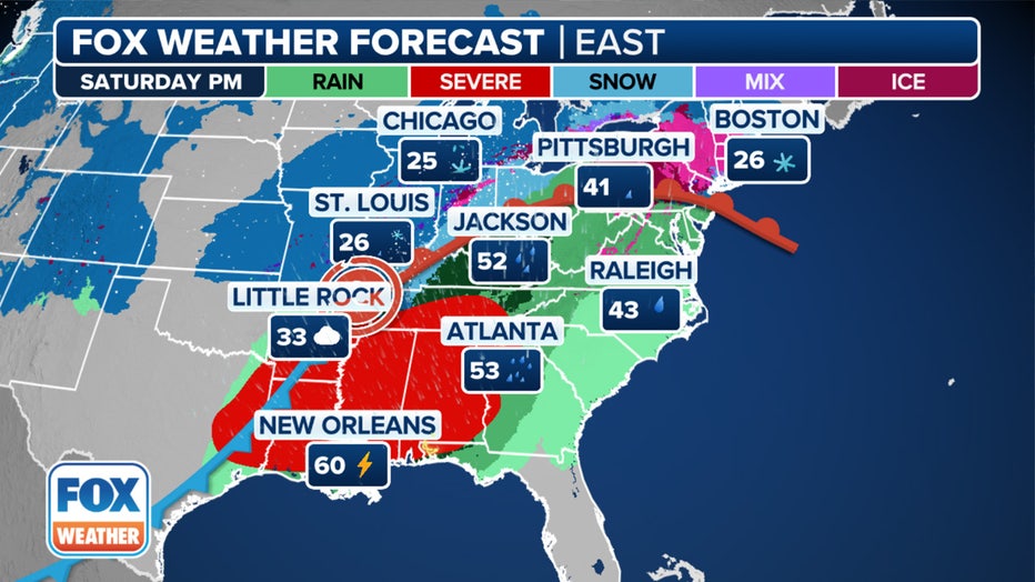
Storms move into the East on Saturday. (FOX Weather)
- Sunday: Rain before 1 p.m., then showers, mainly after 1 p.m. The chance of precipitation is 100%.
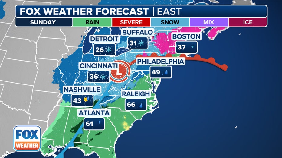
Storms linger in the East on Sunday. (FOX Weather)
- Sunday night: Showers likely before 7 p.m. Mostly cloudy, with a low around 30. Breezy. The chance of precipitation is 60%.
How much snow are we getting Saturday?
- Lower Hudson Valley, interior northeastern New Jersey, southern Connecticut: 2 to 4 inches of snow, with local amounts up to 5 inches.
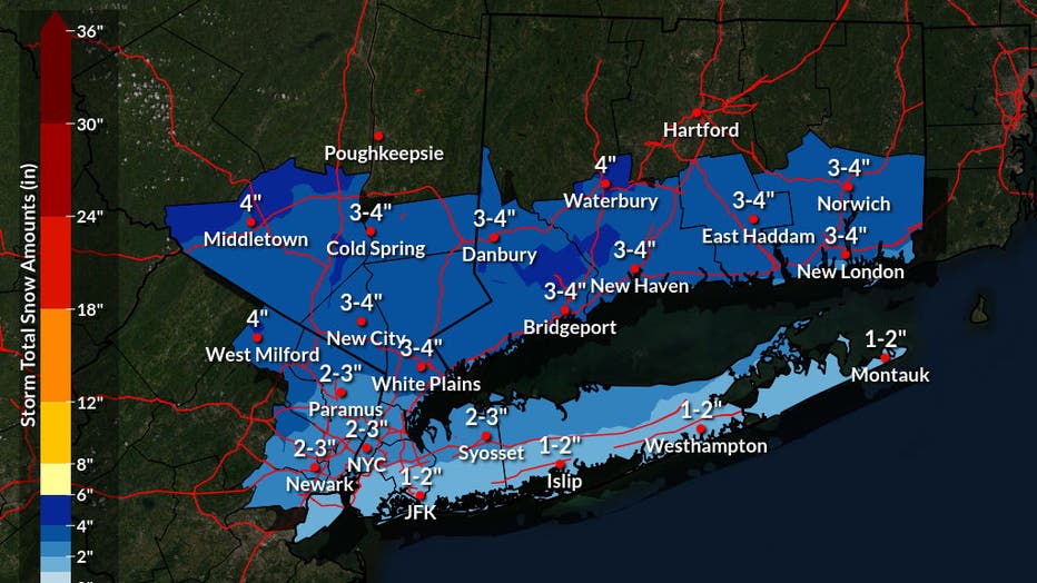
Photo credit: The National Weather Service.
- NYC metro and Long Island: 1 to 2 inches of snow, with local amounts up to 3 inches.
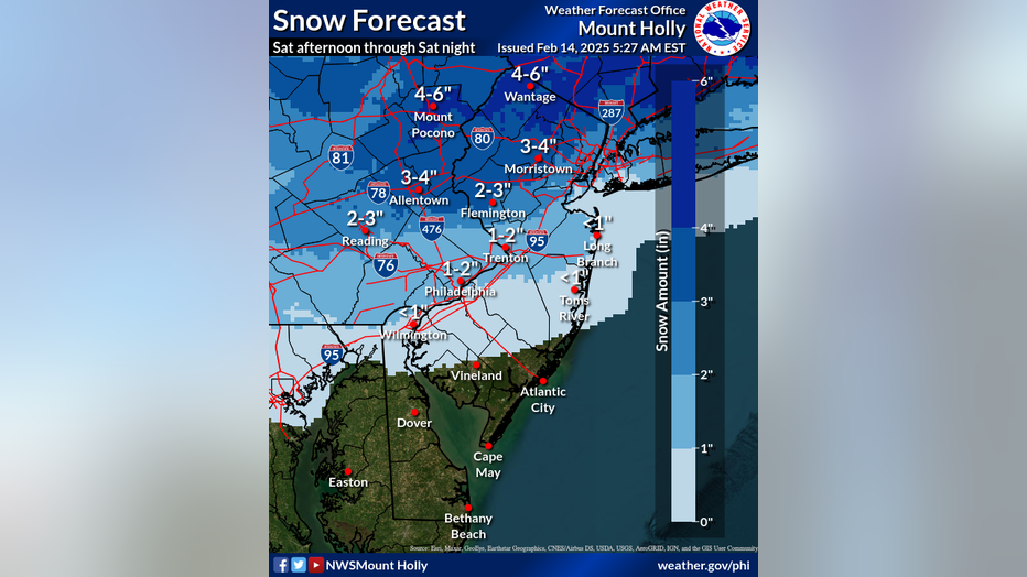
Photo credit: The National Weather Service.
In New Jersey, widespread rainfall ranging from 1 to 2 inches could lead to localized minor flooding on Saturday afternoon through Sunday.
Meanwhile, Sunday evening through Monday could feature winds 20-40 mph with gusts ranging from 45-60 possible, which could lead to power outages and tree damage.
What they're saying:
"It starts off as snow, moderate to even heavier pockets coming through as we head toward the evening, but then the warmer temps start pulling in and that changes things over to rain in the overnight hours, but not before we do see some accumulation coming through," FOX 5 NY's Mike Woods said.
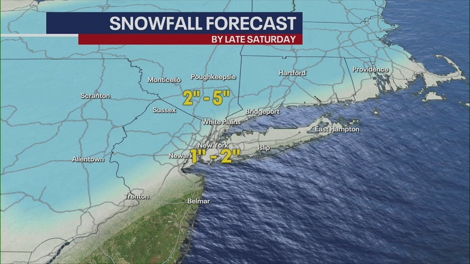
FOX 5 NY's Mike Woods snowfall forecast
"The blue-shaded areas is where you get 2 to 5 inches of snow likely, about 1 to 2 for the gray-shaded areas, which does include the city," Woods said.
Why you should care:
Travel could be hazardous at times due to the snow-covered roadways.
What we don't know:
The exact timing of the precipitation transition to plain rain could impact snow and ice amounts.
Snow storm NYC next week
What's next:
The NOAA's Climate Prediction Center's Hazards Outlook map shows a "slight risk of heavy snow for portions of the Appalachians, Southeast, and the Mid-Atlantic" on Thursday, Feb 20.
FOX Weather LIVE updates
NYC weather radar
Click HERE for more information.