

NYC weather today: Second round of heavy rain, gusty winds on the way l Forecast
NEW YORK CITY - Click here for the latest updates on the NYC weather forecast.

NYC weather: When will it rain again?
The NYC weather forecast shows a storm packing heavy rain and strong winds could cause flooding and commuting headaches throughout the day Wednesday.
The NYC weather forecast shows a storm packing another round of heavy rain and strong winds could cause flooding and commuting headaches throughout the day Wednesday.
A Wind Advisory will be in effect from 4 p.m. Wednesday to 7 a.m. Thursday for the Tri-State area. Gusts as strong as 50 miles per hour are possible.
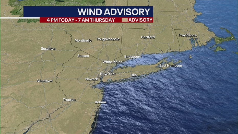
Wind Advisory for the Tri-State area.
"We have wind speeds coming through at 15, 25 mph, but gusts could go as high as 45, 50 across the entire Tri-State region," FOX 5 NY's Mike Woods said.
Though temperatures are warming to a high of 60, the cross-county storm will ruin any changes for fun in the sun – and instead create a messy commute. But will that warm weather hold out for the weekend?
Here's what we know about the forecast:
Timeline of NYC storm
Wednesday
Intermittent rain. Despite the wet weather, expect springlike temperatures, with a high around 60. Skies will be cloudy, conditions will be breezy. Chance of precipitation: 50%.
"The biggest storms come through this evening, and that's when the heavy downpours come through," Woods said.
Wednesday night
A bitter cold front will push the storm into the Atlantic Ocean Wednesday night, bringing strong wind gusts with it. Temperatures will dip near freezing. The rain could end in some snow showers across the area. Chance of precipitation: 100%.
Some of the storms could produce gusty winds and heavy rain. The strongest wind speeds are expected immediately ahead of, and again in the wake of the cold frontal passage, between 6 p.m. and 11 p.m. Wednesday," according to the National Weather Service.
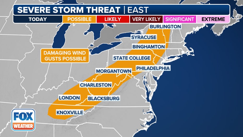
This graphic shows the severe weather threat on Wednesday, Feb. 28, 2024. (FOX Weather)
Thursday
Sunshine returns but the wind gusts continue. The Wind Advisory, however, ends at 7 a.m. Highs will reach 42 degrees.
Impacts: Where will it snow Wednesday?
Snow is also possible across portions of western and central New York state.
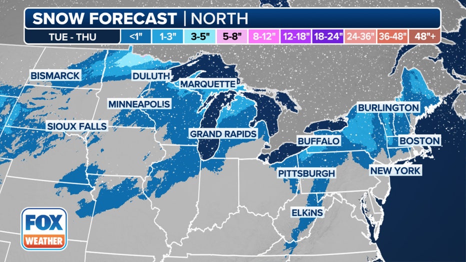
This graphic shows forecast snow totals in the northern tier.(FOX Weather)
"This will all move eastward and on the backside of it, we're going to have cold air rushing in, and we're going to see lake effect snow, possibly affecting portions of Hudson Valley with a couple of snow showers too," Puente said.
Weekend forecast
Though temperatures dip colder on Thursday and Friday, temperatures will rebound back into the 50s on Saturday.
Expect morning showers, but skies should clear in time to enjoy the afternoon.
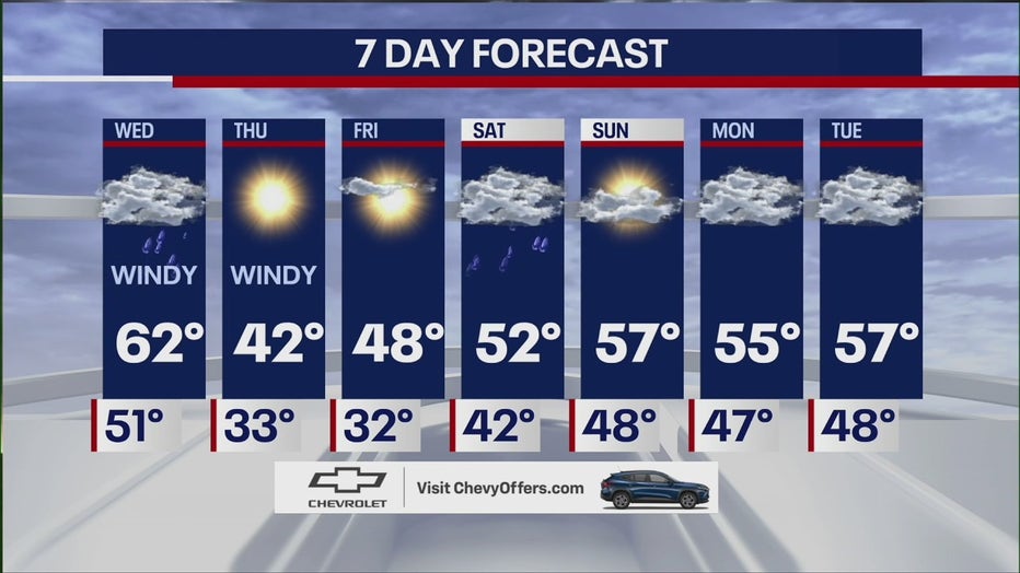
Saturday: A 50% chance of rain. Mostly cloudy, with a high near 53.
Sunday Partly sunny, with a high near 55.
When will it snow again in NYC?
Arctic outbreaks look highly unlikely as we wrap up meteorological winter at the end of the month, the FOX Forecast Center said.
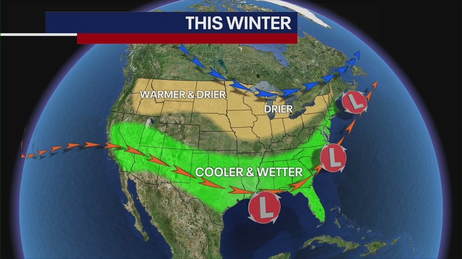
The U.S. is experiencing a strong El Niño, meaning the Tri-State is more likely to see warmer-than-average temperatures and wetter-than-average precipitation.
Though winter is coming to an end, strong El Niño conditions will continue, meaning March will feature the same type of weather we've seen: above-average temperatures and borderline rain-snow events.
The first day of spring 2024 is Tuesday, March 19.