

Snow and rain expected across the NYC area: See forecast
Rain, snow, ice possible for much of the week: See forecast
FOX 5 NY's meteorologist Mike Woods has the latest forecast.
NEW YORK - Rain and a messy wintry mix are causing delays and some school closings across parts of the Tri-State area Tuesday.
What we know:
The soggy stretch of weather is expected to continue for much of the week, according to FOX 5 NY meteorologist Mike Woods.
"Sun’s out, guns out — but not today," Woods said, describing the gray skies hanging over the city this morning.
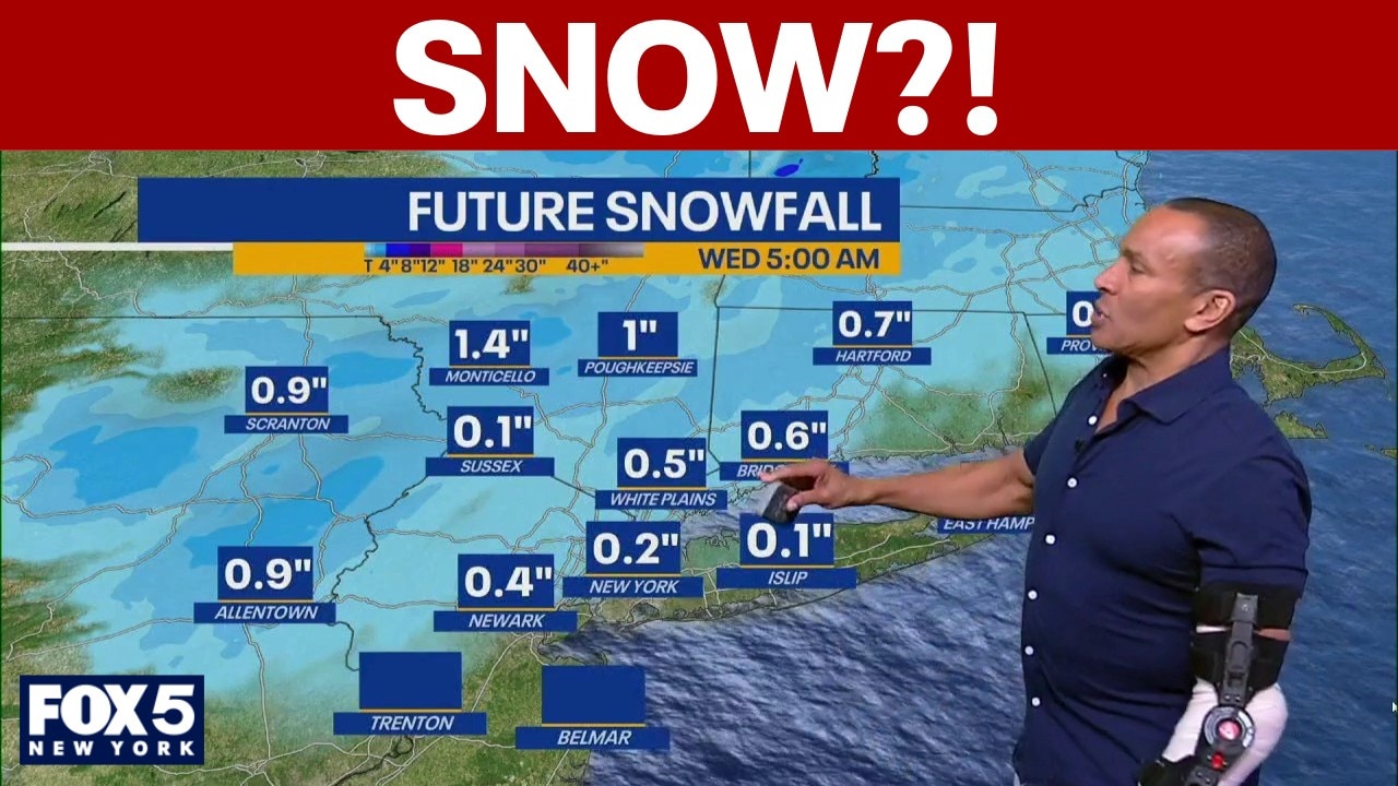
Winter weather advisory

Dig deeper:
A winter weather advisory is in effect for parts of the Tri-State area starting at 10 a.m., though New York City, Long Island and other coastal areas are not included. Areas north and west of the city could see minor snow and ice accumulations through the evening, enough to create slick conditions and impact the commute.
In the city, temperatures hovered around freezing early Tuesday, with 32 degrees in Central Park. Islip sat at 29 degrees, and East Hampton dipped to 22 degrees.
Rain-snow mix

NEW YORK CITY - FEBRUARY 06: Cars drive through light morning snow in Brooklyn on February 06, 2025 in New York City. New York City received about an inch of snow before the precipitation turned into all rain. (Photo by Spencer Platt/Getty Images)
Woods said a rain-snow mix will move into the region by mid-morning, arriving from Pennsylvania and pushing through Trenton before tracking toward the city.
The precipitation may begin as wet snowflakes or a mix, but warmer air moving in from the southeast will flip most locations over to plain rain by the afternoon.
Snow accumulation

The National Weather Service says coastal locations will see a brief period of snow Tuesday morning before it changes to plain rain by midday. Interior areas will start out as snow, transition to a wintry mix during the afternoon, and then switch to plain rain by the evening.
Forecasters expect light ice accretion and minor snowfall, which could create slick spots during the morning and afternoon hours.
A glaze of ice, up to a few hundredths of an inch, is expected.
NYC weather for Tuesday evening

7-day Forecast:
Futurecast models show steadier rain developing later in the day, with pockets of moderate to at times heavy showers possible this evening and into tonight.
Snowfall totals are expected to remain light, with a coating to a half-inch possible north and west of the city. A few spots could see up to an inch of snow and minor ice accumulation, but metro areas are expected to see mainly rain.
Rainfall totals will likely range from about a third of an inch to two-thirds of an inch, though those numbers could fluctuate slightly.
50 degrees on Wednesday
Conditions begin to dry out early Wednesday as drier air pushes in. The day will turn partly to mostly cloudy, with highs in the upper 40s to low 50s.
But the break won’t last long.
Clouds return Thursday, Friday
More clouds and showers return Thursday, with additional rain expected Friday. "We’re kind of in a stretch now for the next four days that we’re going to see some scattered showers coming through from time to time," Woods said.
The weekend, however, looks drier — and much warmer. Temperatures could climb close to 70 degrees by Sunday and Monday.
For now, New Yorkers should keep umbrellas handy and prepare for a damp and unsettled week.
The Source: This is based on information from FOX 5 NY's Mike Woods.