

Wind, rain, snow blasts Northeast as powerful storm tracks across eastern US
NEW YORK - A powerful storm system that spawned deadly tornadoes across parts of the South on Saturday continues to track across the eastern U.S., with high winds, heavy rain and snow expected to blast the Northeast into Monday.
According to the FOX Forecast Center, the storm's impacts will vary by location in the Northeast and New England because of unseasonably warm temperatures for December.
Local National Weather Service offices have issued various weather alerts, from High Wind Warnings to Winter Storm Warnings to Flood Watches.
East Coast storm timing
Precipitation from the powerful storm system will spread eastward Sunday into Monday across the mid-Atlantic, Northeast and New England, including the highly populated Interstate 95 corridor.
On Sunday, everyone from the Appalachians to the East Coast will feel the impacts from either rain, snow or non-thunderstorm gusty winds.
This includes New York City, Philadelphia and Boston, where travel delays will likely stretch from Sunday through the beginning of the workweek.
All the precipitation is expected to clear the coast by late Monday, but winds will remain elevated into Tuesday.
Multiple weather alerts issued in Northeast
Impacts from the powerful storm system will vary by location, with some communities seeing rain changing to snow while others see all rain.
Computer forecast models show nearly everyone will see strong winds, but those along the immediate East Coast are expected to see the highest gusts.
Snow is a threat across the interior Northeast, where cold air will push into the region Sunday night into Monday. Winter Storm Warnings and Winter Weather Advisories have been issued for parts of upstate New York, northeastern Pennsylvania, western Massachusetts, Vermont and northern New Hampshire.
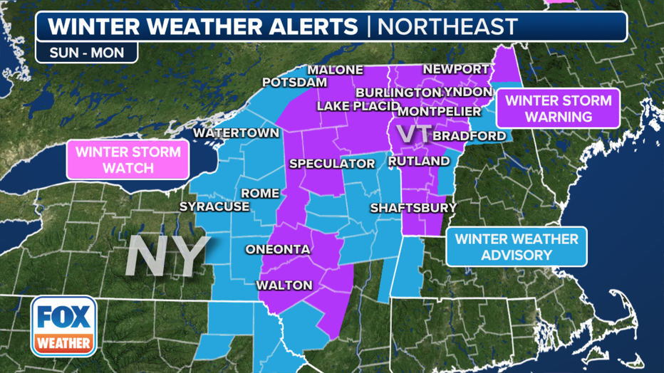
Winter weather alerts are in effect across the Northeast. (FOX WEATHER)
Between 5 and 8 inches of snow is possible over the higher elevations of the interior Northeast, with locally higher amounts of a foot or more in the Green Mountains of Vermont. Snowfall rates are expected to be the heaviest Monday morning, likely impacting the commute to work and school.

The snowfall forecast through Tuesday, Dec. 12, 2023. (FOX WEATHER)
While the accumulating snow is expected to stay west and northwest of Interstate 95, the wind and rain will likely cause problems from the I-95 corridor to the coast.
The greatest impacts from the storm will be caused by the wind and rain, with more than 50 million under Flood Watches from Virginia to Maine.
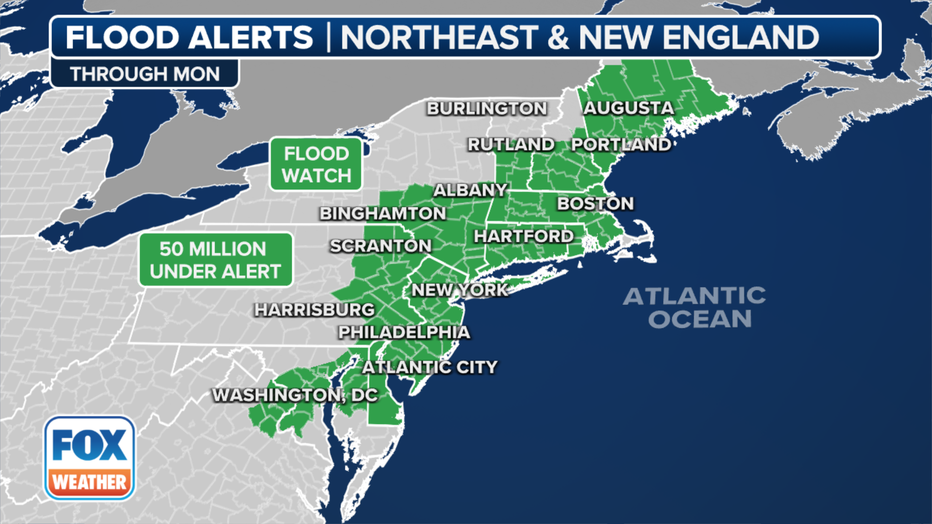
Flood Watches are in effect across the Northeast. (FOX WEATHER)
According to the FOX Forecast Center, widespread rainfall totals between 1 and 3 inches are expected, with locally higher amounts possible in some areas along the coast and in New England.
Nearly three dozen river gauges were already near or above flood stage before the storm started impacting the Northeast.
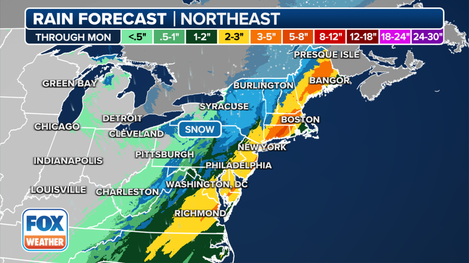
The rainfall forecast for the Northeast through Monday, Dec. 11, 2023. (FOX WEATHER)
As for wind, widespread gusts between 40 and 50 mph are expected Sunday evening, with gusts possibly reaching 60 mph or higher along the New England coast, according to the National Weather Service.
Parts of New Jersey, New York, Connecticut, Rhode Island, Massachusetts, New Hampshire and Maine are under a High Wind Warning or Wind Advisory and face the possibility of downed trees and power lines.
In New York City, a Wind Advisory is in effect only for Brooklyn and Queens. Parts of the Five Boroughs were previously under a High Wind Watch for the first time in nearly three years, but that alert has since been dropped.
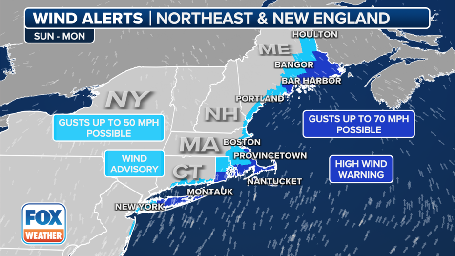
Wind alerts are in effect across the Northeast. (FOX WEATHER)
New York City Emergency Management Department issued a travel advisory for both Sunday and Monday. New Yorkers were urged to plan for extra travel time and use public transportation.
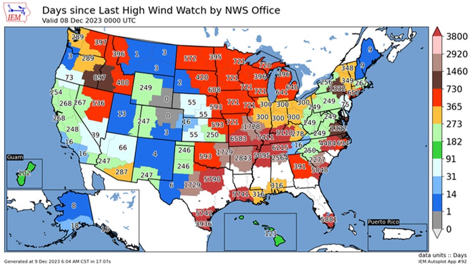
Number of days since each National Weather Service office has issued a High Wind Watch, through Dec, 8, 2023. ((IEM / Iowa State University))
Wide-ranging impacts from the storm in the Northeast
From Sunday into Monday, the greatest impact will be on travelers, power lines and holiday decorations.
In the higher elevations of New York, Vermont and New Hampshire, several inches of snow will likely reduce visibility and make travel treacherous on rural roadways.
Those who do not see snow will deal with strong winds and heavy rainfall that will create slick streets.
Boston Logan International Airport and all major airports in the New York City tri-state area will not be immune from the weather. According to the FOX Forecast Center, significant delays at the major hubs may occur on Sunday and into the early part of the workweek.
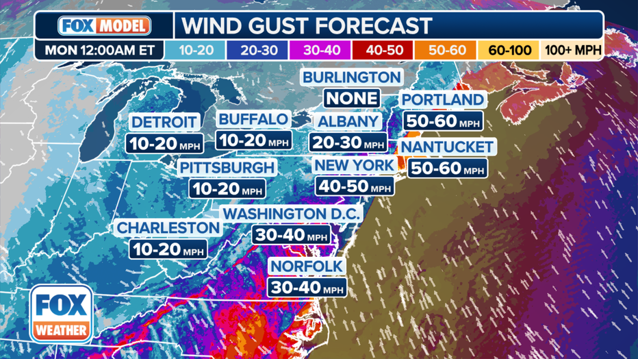
The wind gust forecast for late Sunday night, Dec. 10, 2023. (FOX WEATHER)
Communities that see strong winds and downed trees will be subject to power outages.
Falling branches begin to start causing issues when winds reach around 40 mph – the strength of a weak tropical storm.
This powerful storm could be the most significant weather system to impact the power grid since Hurricane Lee knocked out electricity to hundreds of thousands of homes and businesses in September.
In addition to vulnerable power lines, the winds will likely be strong enough to damage outdoor holiday decorations. Christmas inflatables and trees can be susceptible to high winds if improperly secured.
FOR UPDATES ON THIS STORY, VISIT FOXWEATHER.COM