

NYC snow timeline: 2-5 inches in forecast

Weekend snow storm to slam northeast, NYC
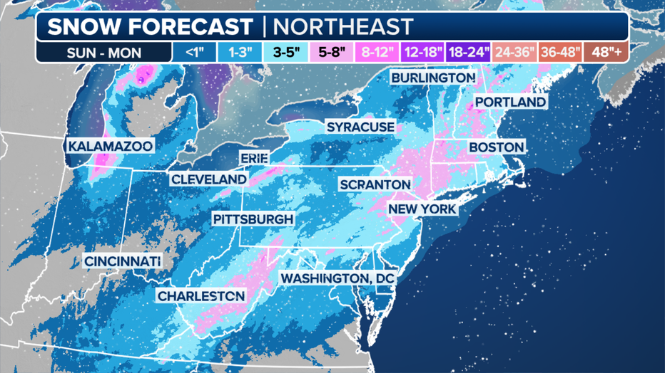
New York City can expect 3 to 5 inches of snow as a weekend snow storm approaches from the south.
NEW YORK - Follow the latest storm updates here.
An approaching winter storm could bring significant snowfall to the New York City area on Sunday, followed by a dangerous blast of artic air delivering wind chills as low as -15 degrees.
JUMP TO: TIMELINE | EXPECTED SNOW TOTALS | POLAR VORTEX
A Winter Storm Watch was issued for suburbs and exurbs in New York, New Jersey and Connecticut as the fast-moving low-pressure system from the south speeds up the East Coast.
Expected snowfall (FOX Weather)
Here's a detailed timeline of when NYC will see snow, how many inches to expect and what's forecast to happen when a polar vortex sweeps the area next week:
Snow, winter storm and polar vortex timeline
Timeline:
Here's what we can expect this weekend and next week.
Saturday: The NYC-area will see relatively warmer temperatures, with highs in the 40s. Expect afternoon and evening showers.
Sunday morning: The Tri-State will see a mix of snow and rain before 1 p.m. Temperatures will likely rise slightly above freezing closer to the city and coast.
Sunday afternoon: A Winter Storm Watch takes effect in the Lower Hudson Valley, interior northern New Jersey and most of interior Connecticut. A Hazardous Weather Outlook takes effort for the city, nearby New Jersey suburbs, Long Island and coastal Connecticut.
- When does snow begin to fall? The snow-rain mix is forecast to transition to snow around 1 p.m.
- How fast will snow fall? Peak snowfall rates will be around a half-inch to 1 inch per hour.
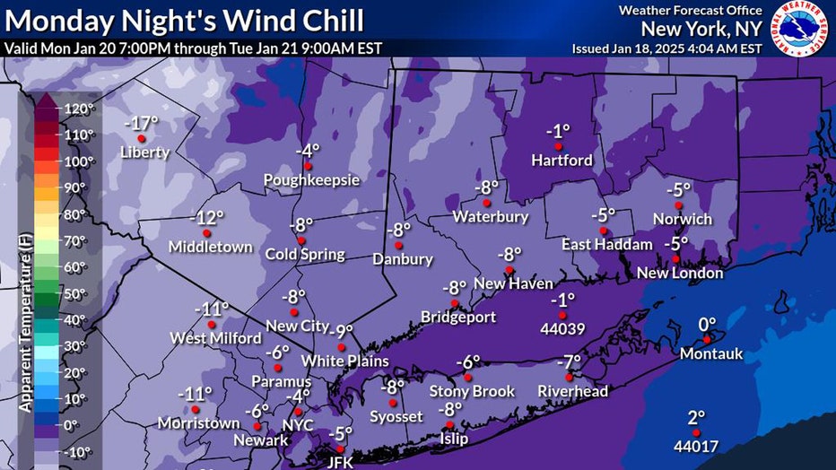
Sunday evening: Temperatures in the city are expected to fall below freezing by 5 p.m. Travel conditions are expected to be hazardous due to slippery travel. Wind chills will be 20 to 30 degrees.
Sunday night: Snow continues to fall throughout the night.
Early Monday morning: Snow will start to dissipate around 1 a.m. The Winter Storm Watch ends at 4 a.m. Wind chills could be as low as 5 degrees.
Monday: Expect sunny skies, with high temperatures in the 20s before dipping into the teens. Expect wind chills as low as -5 to -15 degrees into early Tuesday morning.
Tuesday and Wednesday: Highs will linger in the teens, maybe reaching 20 degrees. Expect wind chills between 0 and -10° Tuesday night into early Wednesday morning.
How many inches of snow will we see?
By the numbers:
New York City and the nearby suburbs can expect between 2 and 5 inches of snow, according to the National Weather Service. The Lower Hudson Valley, interior New Jersey and most of Connecticut will see totals ranging between 5 and 8 inches. Eastern Long Island may see primarily rain.
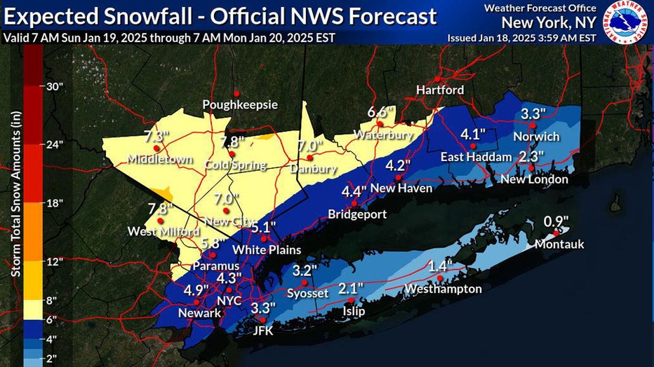
Expected snow totals (NWS)
If heavier snow banding develops over the region, New York City could see up to 7 inches of snow, with 10 to 11 inches possible for the Lower Hudson Valley.
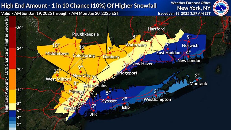
High end snow totals (NWS)
At the very least, the suburbs (excluding Long Island) will see a dusting of snow. We'll see lower-end snow totals if the storm tracks closer to the coast, creating warming conditions, or moves much further offshore.
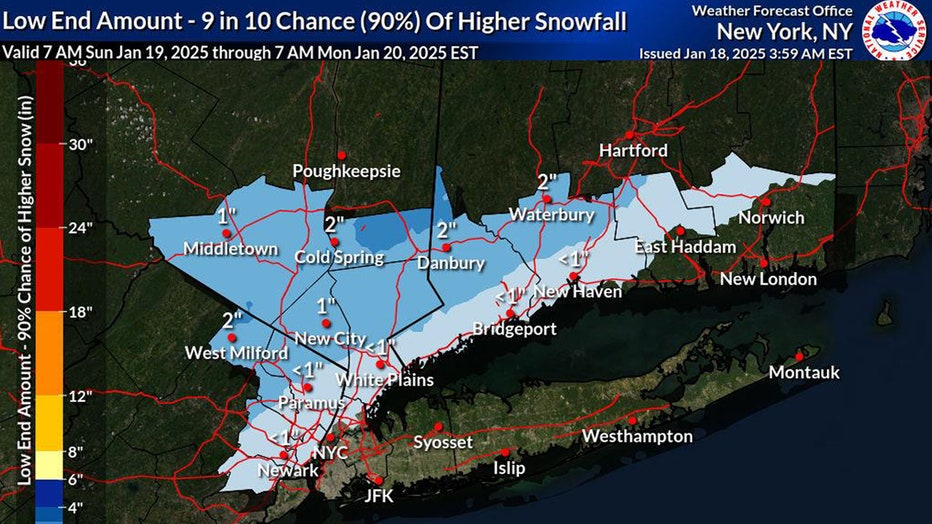
Low end snow totals (NWS)
What we don't know:
The exact track of the low-pressure system remains uncertain. If it moves closer to the coast, snow amounts may decrease in the NYC metro area but increase inland. Conversely, if it tracks further offshore, coastal areas may see higher snow totals.
Live snow cameras
Track the storm as it moves up the East Coast with our YouTube livestream! We have live pictures from NYC, D.C., Philly and more below:
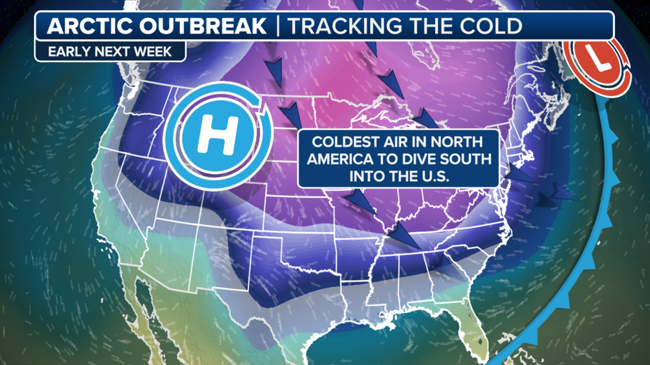
Next week's polar vortex
Big picture view:
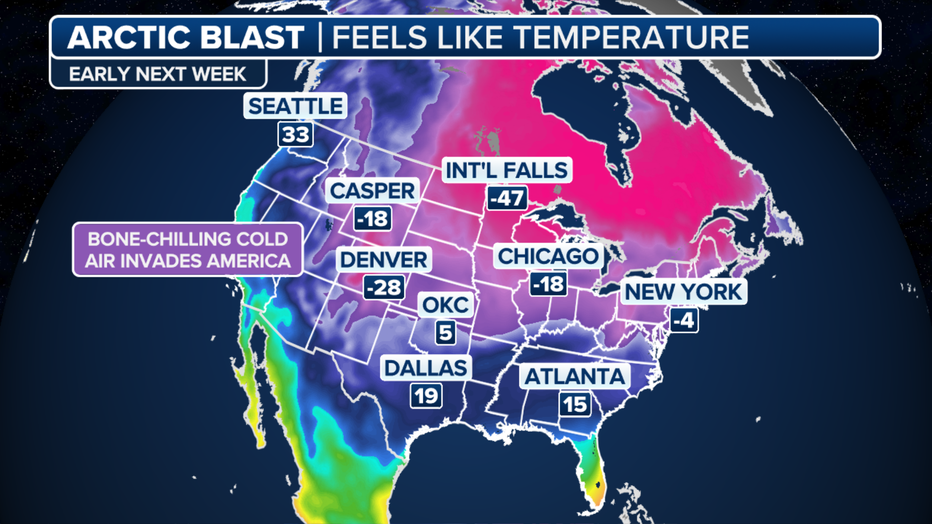
This weekend and into next week, a lobe of the polar vortex will descend into the U.S. and bring with it brutally cold temperatures.
The FOX Forecast Center said temperatures will plummet as much as 45 degrees below average in spots, leading to below-zero temperatures across at least 20 states, from the Plains to the Great Lakes and interior Northeast.
Preparations for the cold weather are already underway in New York City. According to New York City Emergency Management, a Cold Weather Alert has been issued and the New York City Department of Public Health declared a Cold Blue.
"Outreach teams will canvass all five boroughs to connect our most vulnerable New Yorkers to shelters," NYCEM said on X. "No one who is homeless and seeking shelter in New York City during a Code Blue will be denied."
The Source: This article uses reporting from the National Weather Service and FOX Weather.