

NYC storm alert: Heavy rain, flooding, gusty winds threaten Tri-State area | Forecast

NEW YORK CITY - After a warm start to the week in NYC, attention now turns to a storm threat Thursday that could bring heavy rain, potential flooding and gusty winds to the Tri-State area.
JUMP TO: RADAR l TIMELINE l IMPACTS l WHAT'S NEXT?
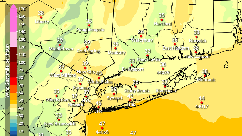
The system is expected to bring heavy rain this afternoon and evening, eventually ending Friday morning. Wind gusts around 45 mph are also possible, especially closer to and along the coast, according to the National Weather Service.
(NWS)
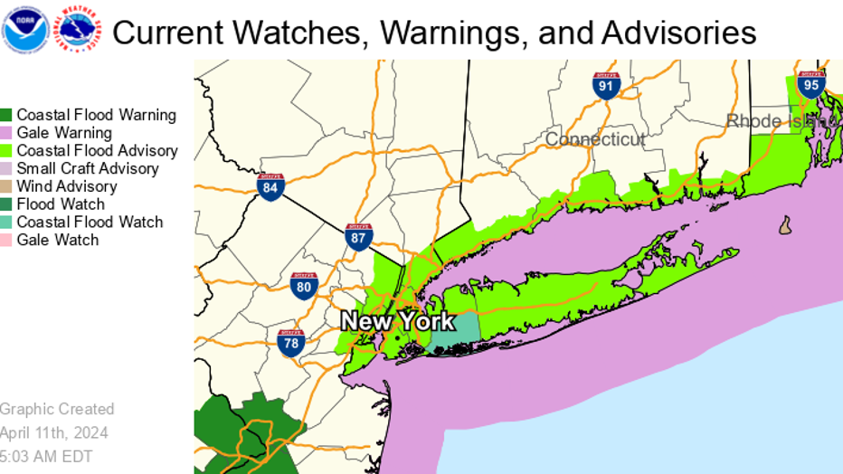
Coastal flood advisories are in effect, with a coastal flood watch issued for coastal Nassau County on Long Island.
(NWS)
"There are those scattered showers coming through later this evening into tonight, into tomorrow morning, pockets of rain, which will be heavy at times, maybe a thundershower coming through," FOX 5 NY's Mike Woods said.
Here's everything you need to know about the storm system, including when it will rain, how much it will rain and what's next after the rain.
NYC weather radar
Click HERE to see the weather radar across the Tri-State area.
Timeline: When will it rain in NYC?
Today: Showers likely, mainly after 5 p.m. Cloudy, with a high near 61. Chance of precipitation is 60%.
Tonight: Showers and possibly a thunderstorm. Temperature rising to around 61 by 1 a.m. Windy, with gusts as high as 40 mph. Chance of precipitation is 100%.
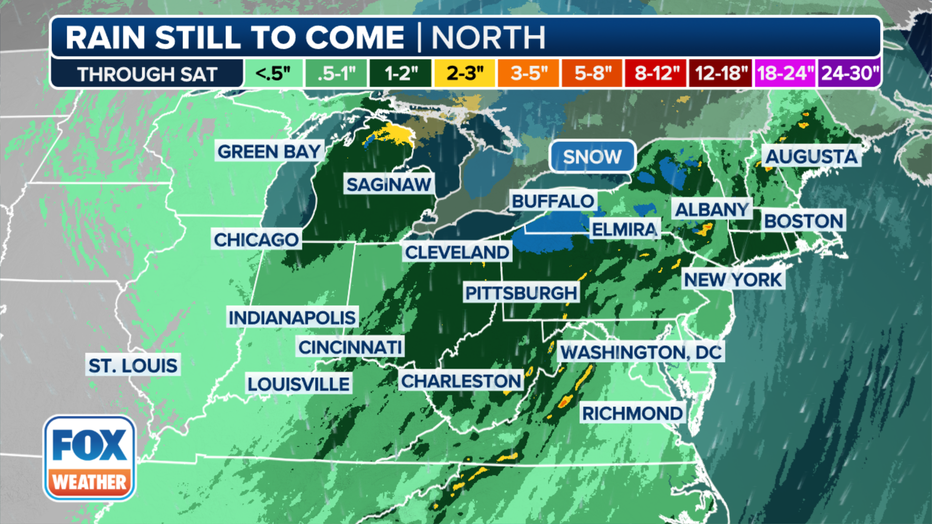
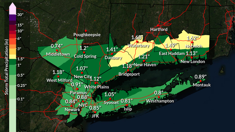
This graphic shows the forecast rain totals through Saturday, April 13, 2024. (FOX Weather)
Friday: Showers likely and possibly a thunderstorm. Mostly cloudy, with a high near 63. Breezy, with a southwest wind 21 to 23 mph. Chance of precipitation is 60%.
"Friday looks like it could be somewhat active again, with pockets of showers and storms," Woods said.
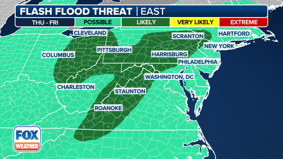
This graphic shows the flash flood risk on Thursday, April 11, 2024. (FOX Weather)
Friday night: A 30% chance of showers, mainly before 8 p.m. Mostly cloudy, with a low around 51. Breezy, with a southwest wind around 20 mph.
Impacts: How much will it rain in NYC?
Most locations being impacted by the system will only see about 1-2 inches of rain through Saturday, with some locally higher amounts of 2-3 inches in parts of upstate New York.
(NWS)
However, the ground is already extremely saturated from relentless rain that has been pounding the region since the start of the year. Needless to say, even low precipitation totals could lead to flash flooding.
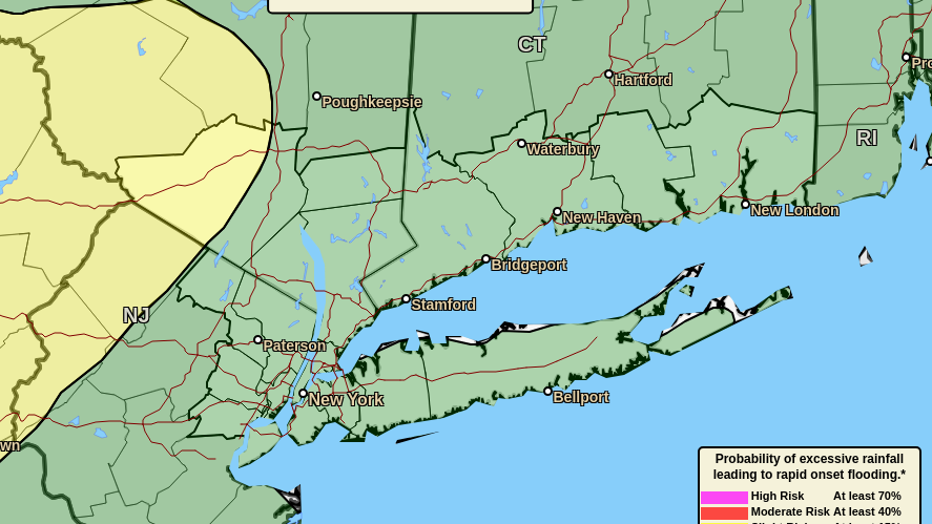
(NWS)
Because of that risk, NOAA’s Weather Prediction Center has placed millions of people in a Level 2 out of 4 risk of excessive rainfall on Thursday across portions of the mid-Atlantic into southern New York state.
What's next after the rain?
Saturday: Mostly cloudy, with a high near 56. Breezy, with gusts as high as 32 mph.
"For the most part, we should get the drier weather as we head into the weekend," Woods said.
Saturday night: Partly cloudy, with a low around 49.
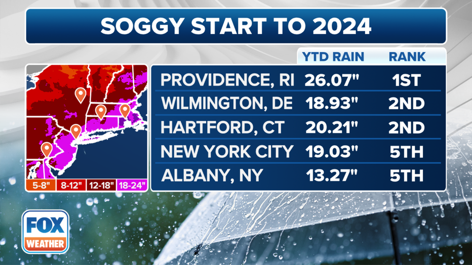
This graphic shows cities that have seen an extremely wet start to 2024. (FOX Weather)
Sunday: Mostly sunny, with a high near 64.
Sunday night: A chance of showers between 8 p.m. and 2am. Mostly cloudy, with a low around 55. Chance of precipitation is 30%.
FOX Weather's Steven Yablonski helped contribute to this report.