

This weekend could bring more snow, rain for NYC area: See latest weekend forecast
NEW YORK - As March approaches, winter may have one more round of snow in store for the New York City region.
What we know:
After a historic blizzard buried parts of the Tri-State area, forecasters are now watching another potential winter storm that could bring snow or a wintry mix by Sunday into early next week.
JUMP TO: 7-DAY FORECAST | SNOW CHANCES | SPRING WEATHER
Chance of snow this weekend, possibly scenarios

The possible amount of snow in the north. (FOX Weather)
What they're saying:
The FOX Forecast Center says forecast models are still sorting out the exact track and temperature setup, but two main scenarios have emerged.
If colder air holds firm, a corridor from the Ohio Valley to parts of the I-95 corridor could see 6 to 8 inches of snow.
A lower end outcome would bring 1 to 3 inches, with more mixing of sleet and rain.
For the New York, New Jersey and Connecticut region, the key question is where the rain snow line sets up and how much cold air remains in place at the surface.
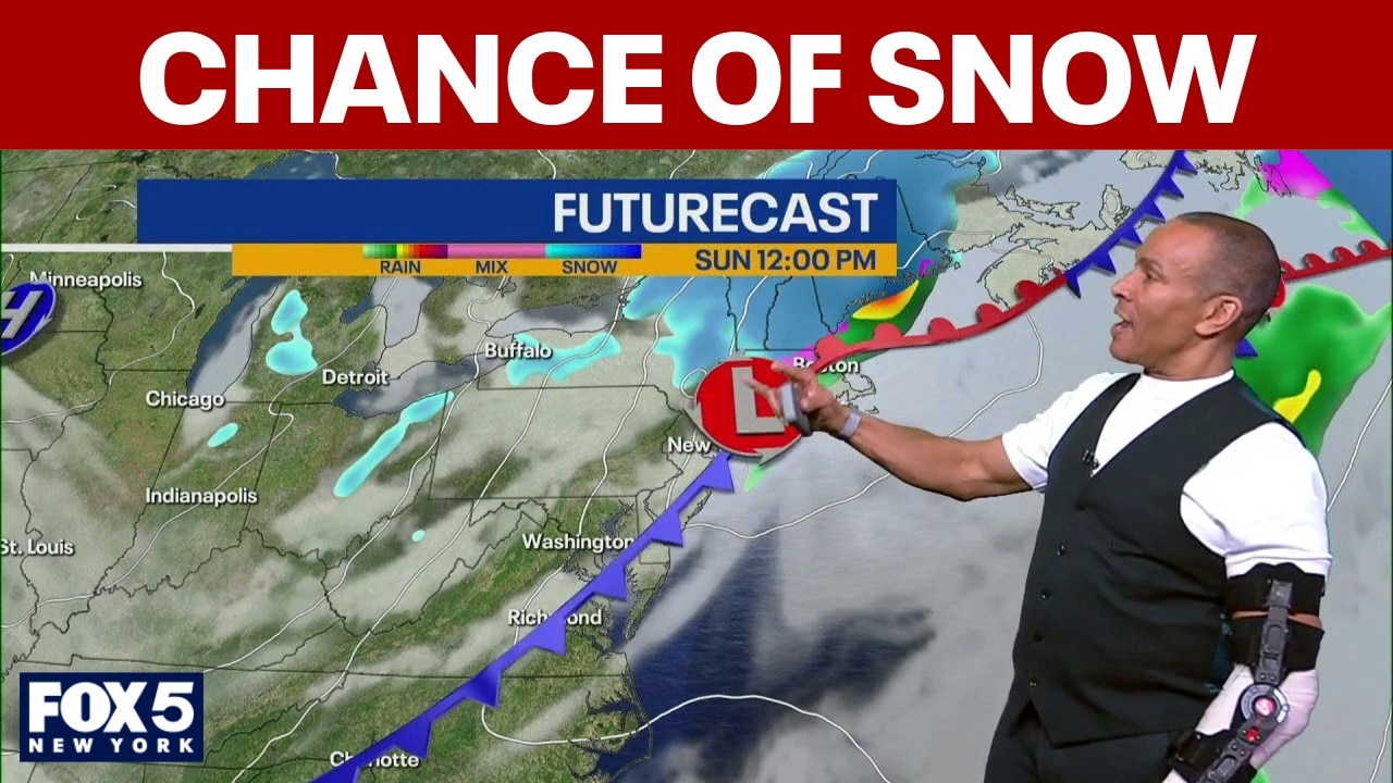
Snow chances Sunday morning

The next system begins to take shape over the weekend.
A shot of colder air settling across the northern tier of the country will set the stage for potential snowfall.
By Sunday, a weak disturbance moving out of the Rockies will push warmer air over that cold surface layer, a setup meteorologists call overrunning.
That process can produce snow, sleet, freezing rain or plain rain depending on temperatures at the ground.
According to Woods, the latest models suggest the heaviest snow will likely fall north and west of the city into upstate New York and New England. The Tri-State area could get clipped by light snow showers Sunday morning.
"A quick little light snow shower for you on Sunday morning is all it would be. Doesn’t even look like it’s accumulating," Woods said.
Even so, brief snow or a light mix could create slick travel early Sunday before conditions improve later in the day.
NYC 7-day weather forecast

In the meantime, the Tri-State area gets a quiet stretch to close out February.
FOX 5 NY meteorologist Mike Woods says sunshine will dominate through Friday and Saturday, with highs returning to seasonable levels in the mid 40s. A southerly wind on Saturday could even push temperatures into the upper 40s to near 50 degrees.
"It’s nice outside. As you can see, we got the sunshine," Woods said, adding that there is no threat of showers through Saturday.
Friday morning began on a cold note, with temperatures around 30 degrees in Central Park, 26 in Newark and 22 in White Plains. That cold allowed for icy spots on roads and sidewalks during the early commute.
When is spring?

Looking ahead, early March appears unsettled. Woods says Tuesday through Thursday of next week look wet, with rain more likely than snow across the city and surrounding suburbs.
While significant accumulation in New York City is far from certain, the potential for another round of wintry weather serves as a reminder that March can still deliver snowstorms to the Northeast.
Forecasters expect the storm track and snowfall totals to come into clearer focus over the next several days.
What's next:
For now, residents can enjoy sunshine and milder temperatures before winter makes another attempt at a comeback.
Spring officially begins on March 20, with the arrival of the vernal equinox.
The Source: This report is based on information from FOX Weather and FOX 5 NY's Mike Woods.