

Could there be two hurricanes in the Gulf? If so, it would be a first

Today’s tropical weather forecast
Meteorologist Jim Weber explains what will happen with Tropical Storm Laura and the likely Tropical Storm Marco.
TAMPA, Fla. - With a new tropical storm and a tropical depression aiming for the U.S., forecasters say both could be swirling in the Gulf of Mexico as hurricanes next week.
If that happens, it would be the first time two hurricanes were in the Gulf at the same time, FOX 13's meteorologist Jim Weber says, going back to the start of record-keeping in 1851.
"Everyone is wondering, 'Have we seen this before?' The answer is no, we have not seen two hurricanes in the Gulf of Mexico before. There's no record of two hurricanes," he explained. "We have had two tropical systems -- either a tropical storm and a depression or two tropical storms -- but we've never actually had two hurricanes in recorded history in the Gulf of Mexico. So we might actually see a first with this."
Tropical Depression 13, east of the Caribbean islands, officially became Tropical Storm Laura this morning. It will skirt the Leeward Islands, Puerto Rico, the Dominican Republic and Cuba, according to the National Hurricane Center. The early, still uncertain track showed it potentially being near Florida by Monday as a hurricane.
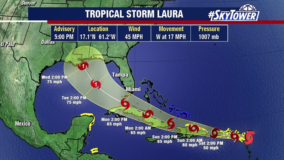
LINK: Tropical Storm Laura track and models
Reconnaissance planes flew through this storm Friday morning, finding winds of 45 mph and a center of circulation further south than first thought.
"If it ends up being further to the south, it would actually have more land interaction. It wouldn't allow this system to strengthen as much," Weber noted.
He said there are several factors that could still come into play with the forecast track in the next several days, including wind shear and some drier air.
"But the general idea is we have a strengthening system heading in the general direction of Florida," he said, "and into the Gulf of Mexico as we get into the first half of next week."
LINK: Forecast models and animations on MyFoxHurricane.com
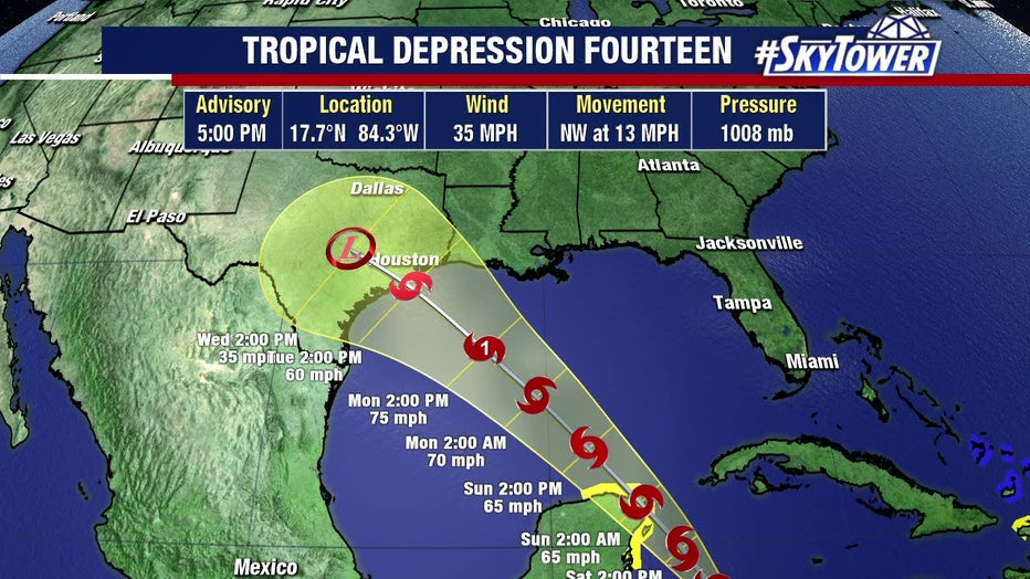
Tropical Depression 14, near Central America, is projected to graze the Atlantic coast of Honduras, then curve northward to Mexico’s Yucatan Peninsula possibly at hurricane strength and then potentially head for the Texas or Louisiana coast by Tuesday, again possibly strengthening into a hurricane. It is expected to become a tropical storm on Friday.
"This one's not looking extraordinarily organized at this point but as it moves over some warmer water, interacts with the Yucatan Peninsula and then works its way up into the Gulf of Mexico, there are conditions that are favorable where we have warm water, light wind shear, so this could end up being a hurricane in the Gulf of Mexico," Weber said.
On the current projected paths, both tropical systems could be Category 1 hurricanes in the Gulf between Monday and Tuesday.
"Everyone is wondering what exactly could happen with this. Could we merge these together and get one giant hurricane? Well that doesn't happen," Weber said. "When you have one that's much stronger than the other, it tends to absorb the weaker one. If they're both around the same strength, they'll move around each other. It's called the Fujiwhara Effect."
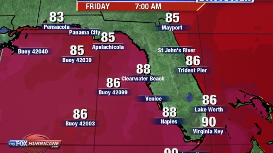
Friday morning's water temperatures
LINK: Forecast models and animations on MyFoxHurricane.com
There is a chance both could even make landfall within hours of each other.
"We're just going to see how that all plays out in the next couple of days," Weber added.
Forecasters predicted a historically active season this year, and so far, that has proven accurate. Of the 12 named storms so far this season, nine were the earliest use of that letter-name ever, the latest being 'Laura.'
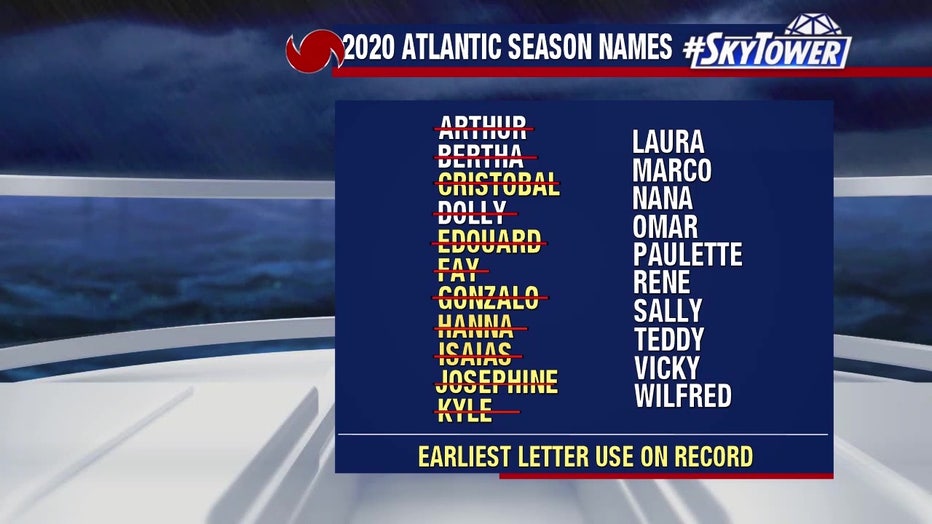
Should all of the alphabetical names get used up, the National Hurricane Center will begin using the Greek alphabet to name storms. That's only happened once before, during the record-breaking season of 2005 -- rememembered most for hurricanes Katrina, Rita, and Wilma.
The next name on the 2020 list after Laura is Marco.

Several waterspouts off coast of Louisana
Reports of waterspouts churning off the Louisiana coastline cropped up around the state Thursday, as videos and images circulated on social media.