

Weekend winter storm could dump 6+ inches of snow in NYC: Timing, how much to expect

NYC winter storm: When to expect snow
FOX 5 NY's Audre Puente says the worst of the snow is expected overnight starting at about 7 p.m. until 1 a.m. Sunday.
NEW YORK CITY - Find the latest snow storm updates here.
Just as one winter storm exited the New York City area, a new one is expected to slam similar areas over the weekend with several inches of snow.
SNOWSTORM NYC: TIMING l TOTALS l NEXT WEEK
The quick-moving storm system is expected to bring accumulating snowfall from Saturday evening into Sunday morning to parts of the region. Snow, sleet and freezing rain are also possible.
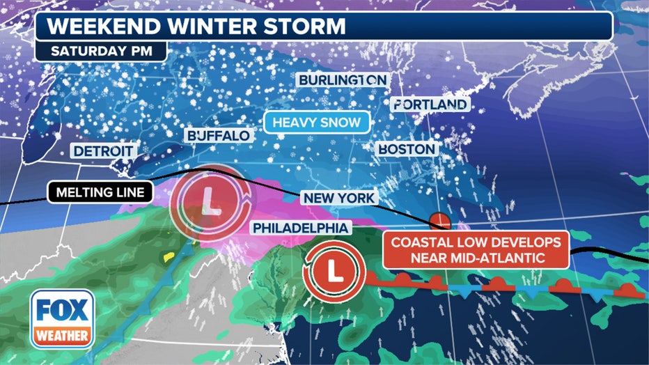
The FOX Forecast Center tracks the weekend winter storm's path Saturday evening. (FOX Weather)
A winter weather advisory is in effect for New York City and the rest of the Tri-State area from 5 p.m. Saturday to 11 a.m. on Sunday, while a winter storm watch is in effect from 7 p.m. Saturday through 10 a.m. Sunday.
North of the city, a Winter Storm Warning is in effect for Ulster, Dutchess, Orange, Putnam and Rockland Counties, along with northern Westchester, western parts of Passaic and Bergen Counties in New Jersey and in southwestern Connecticut.
Timeline: Snow NYC this weekend
Timeline:
According to the National Weather Service (NWS), snow will overspread the region on Saturday evening, possibly transitioning into a wintry mix along the coast.
The snow could develop as early as late Saturday afternoon, becoming steady in the evening and continuing into Sunday morning before tapering off.
- Saturday: A 30% chance of snow after 1 p.m. Mostly cloudy, with a high near 35.
- Saturday night: Snow before 1 a.m., then snow and sleet, possibly mixed with freezing rain between 1 a.m. and 4 a.m., then snow and sleet, possibly mixed with rain and freezing rain after 4 a.m. Low around 33. The chance of precipitation is 100%.
- Sunday: Snow and sleet, possibly mixed with rain before 10 a.m., then a slight chance of rain and snow between 10 a.m. and 1 p.m. High near 37. The chance of precipitation is 80%.
How much snow are we getting Saturday?
By the numbers:
According to the NWS, forecast snowfall amounts have slightly decreased for the Lower Hudson Valley and southern Connecticut, where amounts have slightly increased for the New York City metro, Long Island, and northeast New Jersey. Heavy snow is anticipated the farther north you go.
- For portions of southern Connecticut and southeast New York, heavy snow is possible, resulting in total accumulations between 5 and 7 inches. Snow rates of over 1 inch an hour are possible.
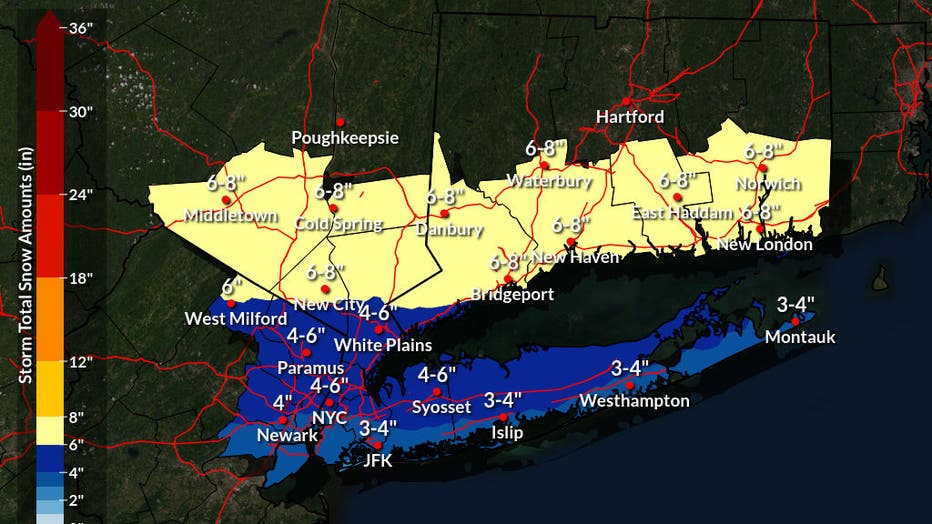
Photo credit: The National Weather Service.
- For portions of northeast New Jersey and other parts of southeast New York, heavy mixed precipitation is possible, resulting in total snow and sleet accumulations between 3 and 5 inches. Plain rain may mix in where temperatures briefly rise above freezing. Snow rates of up to 1 inch an hour are possible.
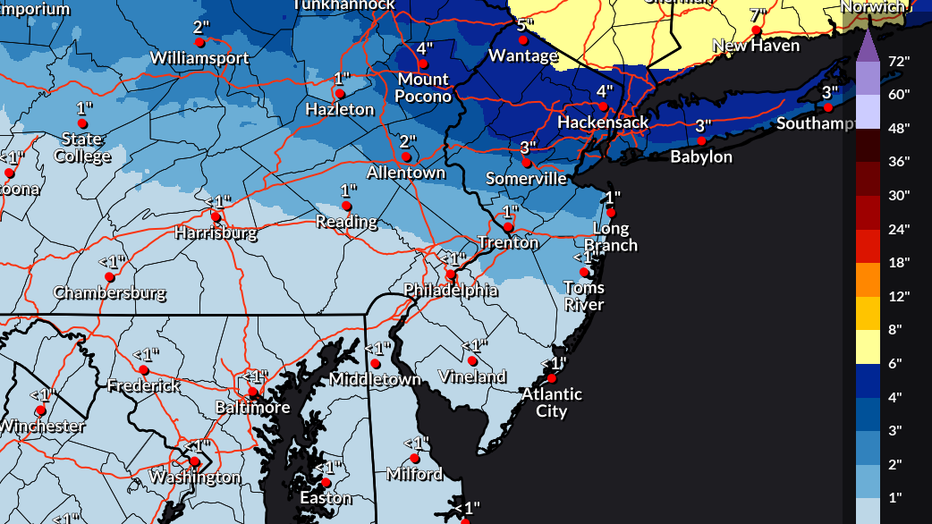
Photo credit: The National Weather Service.
What they're saying:
"As soon as you start heading a little bit to the north, those snow totals go up big time," FOX 5 NY's Mike Woods said.
Snowfall forecast according to FOX 5 NY's Mike Woods
What we don't know:
Uncertainty remains with the storm track and timing, which will play a critical role in where the heaviest snow occurs.

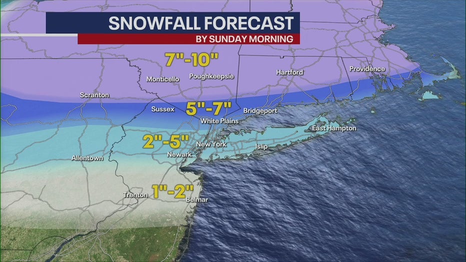
Here's a look at the snow potential through Sunday. (FOX Weather)
What you can do:
Roads, especially bridges and overpasses, will likely become slick and hazardous, making travel difficult.
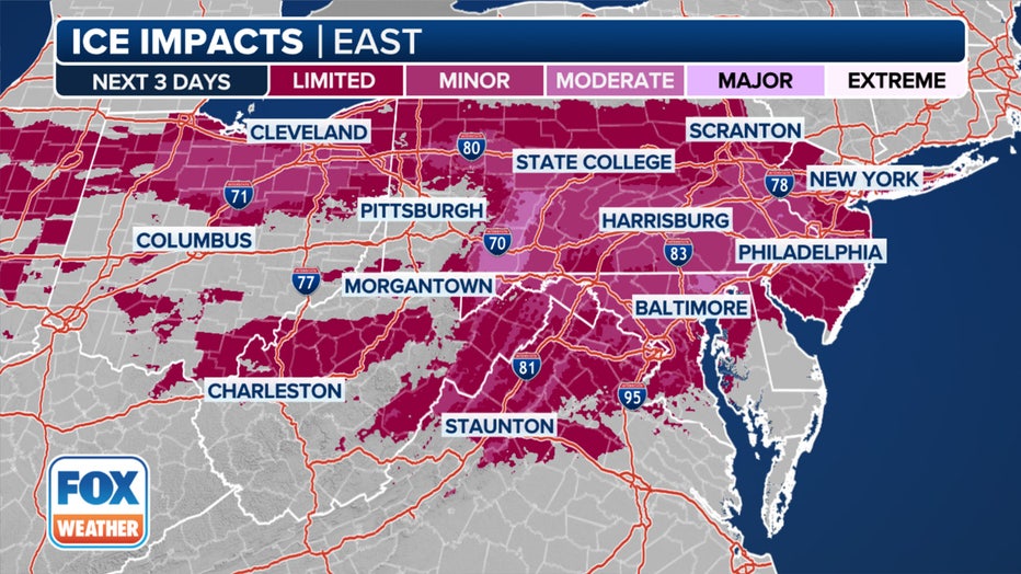
It will be back-to-back ice threats in parts of the Northeast the next three days. (FOX Weather)
"Persons should consider delaying all travel. If travel is absolutely necessary, drive with extreme caution," the NWS said.
Weather next week
But don't get too comfortable – next week has many more chances for snow in New York City.
An active storm track is forecast over the East, where currently, there's a slight risk of heavy snow forecast for the Tri-State area on Wednesday and Thursday. However, uncertainty in the track and precipitation type for each system still remains.
- Tuesday: A 50% chance of snow after 1 p.m. Mostly cloudy, with a high near 35.
- Tuesday night: Snow likely. Cloudy, with a low around 31. The chance of precipitation is 60%.
- Wednesday: A 30% chance of snow. Mostly cloudy, with a high near 37.
- Wednesday night: A 50% chance of snow. Mostly cloudy, with a low around 31.
- Thursday: A chance of rain and snow. Mostly cloudy, with a high near 37. The chance of precipitation is 50%.
FOX Weather live updates
NYC weather radar
Click HERE for more information.