

Winter storm watch issued for NY, NJ this weekend as more snow expected

Winter Storm Watch issued as more snow coming
A Winter Storm Watch has been issued for Connecticut, Long Island, New York City, the Hudson Valley and parts of northern New Jersey as another snowstorm is expected to come our way this weekend. FOX 5's Nick Gregory takes a look at what to expect.
NEW YORK CITY - Just as one storm packing snow and ice exits the New York City area, another is on the way to parts of New York, New Jersey and Connecticut this weekend – and next week, and has brought a Winter Storm Watch with it.
NEW YORK SNOW FORECAST: WEEKEND TIMELINE l WEATHER NEXT WEEK
The Winter Storm Watch from the National Weather service will remain in effect through Sunday morning, with an expected storm on Saturday evening to bring heavy snow and totals of as much as 7 inches of snowfall in parts of southern Connecticut and southeastern New York.
New York City is expected to see total snow and sleet accumulations of 2 to 4 inches, while parts of the Hudson Valley are expected to see anywhere from 7 to 10 inches of snow.
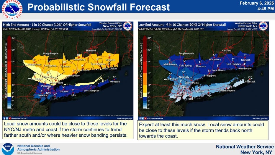
Credit: National Weather Service
The Winter Storm Watch covers Connecticut, Long Island, New York City, the Hudson Valley and parts of northern New Jersey.
Timeline: NYC snow this weekend
Timeline:
The storm will reach the Northeast on Saturday night:
- Saturday: A 20% chance of snow after 1 p.m. Partly sunny, with a high near 36.
- Saturday night: Snow likely before 10 p.m., then snow and sleet between 10 p.m. and 4 a.m., then rain and sleet after 4 a.m. Temperatures will fall to near 32 by 8 p.m., then rising to around 37 during the remainder of the night. The chance of precipitation is 100%.
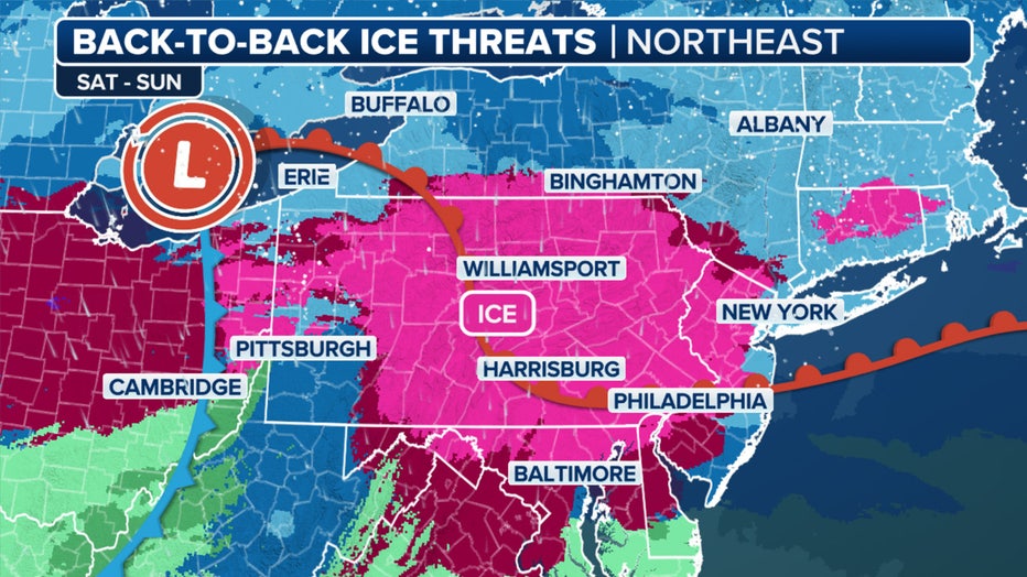
It will be back-to-back ice threats in parts of the Northeast through Sunday. (FOX Weather)
- Sunday: A chance of rain and snow before 9 a.m. Cloudy, then gradually becoming mostly sunny, with a high near 40. The chance of precipitation is 50%.
"More snow and ice will come through late Saturday into Sunday," FOX 5 NY's Mike Woods said.
What they're saying:
"As the storm continues east, an icy wintry mix is anticipated across the northern Mid-Atlantic states Saturday night," the NOAA NWS Weather Prediction Center said in a post on Facebook.
What we don't know:
"Uncertainty remains with the storm track and timing, which will play a critical role in where the heaviest snowfall occurs," the NOAA NWS Weather Prediction Center said in a post on Facebook.

Here's a look at the snow potential through Sunday. (FOX Weather)
Weather next week
What's next:
But don't get too comfortable – next week has many more chances for snow in New York City.
An active storm track is forecast over the East, where currently, there's a slight risk of heavy snow forecast for the Tri-State area on Wednesday and Thursday. However, uncertainty in the track and precipitation type for each system still remains.
- Tuesday: A 50% chance of snow. Mostly cloudy, with a high near 36.
- Tuesday night: A 50% chance of snow. Mostly cloudy, with a low around 29.
- Wednesday: A 30% chance of snow. Mostly cloudy, with a high near 35.
"Snow down the road on Tuesday, Wednesday, it looks like that one's promising a little more snow," Woods said.
NYC weather radar
Click HERE for more information.