

NYC ice storm forecast: Snow timeline, impacts for morning commute

Winter storm to drop sleet, ice on tri-state
A winter storm is set to bring freezing rain, sleet and a few inches of snowfall to the tri-state area on Thursday. FOX 5's Nick Gregory has more details.
NEW YORK - ‘Hazardous’ travel is possible during the Thursday morning commute, as an incoming winter storm is expected to bring a mixed bag of freezing rain, snow, sleet and ice to the New York City area.
NYC SNOW FORECAST: TIMELINE l LOCAL IMPACTS l WEEKEND STORM l RADAR
Winter weather advisories have been expanded to include all the New York City metro, northeast New Jersey, Westchester and southern portions of Connecticut. Click here to track school closings and delays.
Winter weather advisory NYC
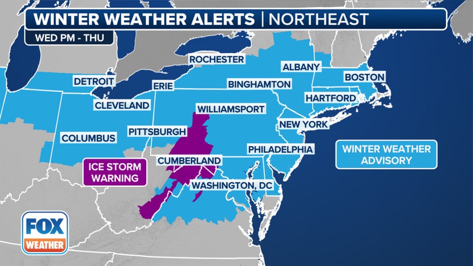
This graphic shows the winter weather alerts in effect in the Midwest. (FOX Weather)
- Interior NE New Jersey, Lower Hudson Valley, Southern Connecticut from 4 a.m. Thursday until 1 p.m. Thursday.
- For NYC metro and western Long Island, the advisory is in effect at 4 a.m. Thursday until 11 a.m. Thursday.
What's the weather today?
Skies will be partly sunny, with a high near 35.
Ice storm forecast
Timeline:
According to the National Weather Service (NWS), snow is expected to develop from the southwest to the northeast after midnight, mixing with sleet and freezing rain by mid to late morning, before tapering as plain rain by the afternoon. The coast and NYC metro will change to rain by late-morning.
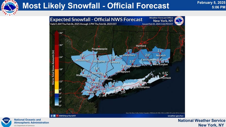
Expected snowfall across the tri-state. (Credit: National Weather Service)
- Wednesday night: A chance of snow between 1 a.m. and 4 a.m., then snow and sleet likely. Mostly cloudy, with a steady temperature around 31.The chance of precipitation is 60%.
Weather forecast tomorrow
- Thursday: Snow, freezing rain, and sleet before 10 a.m., then rain. High near 41. The chance of precipitation is 100%.
New York City could see snow fall during the middle of the Thursday morning commute, which could wreak havoc, especially on untreated roads and surfaces.
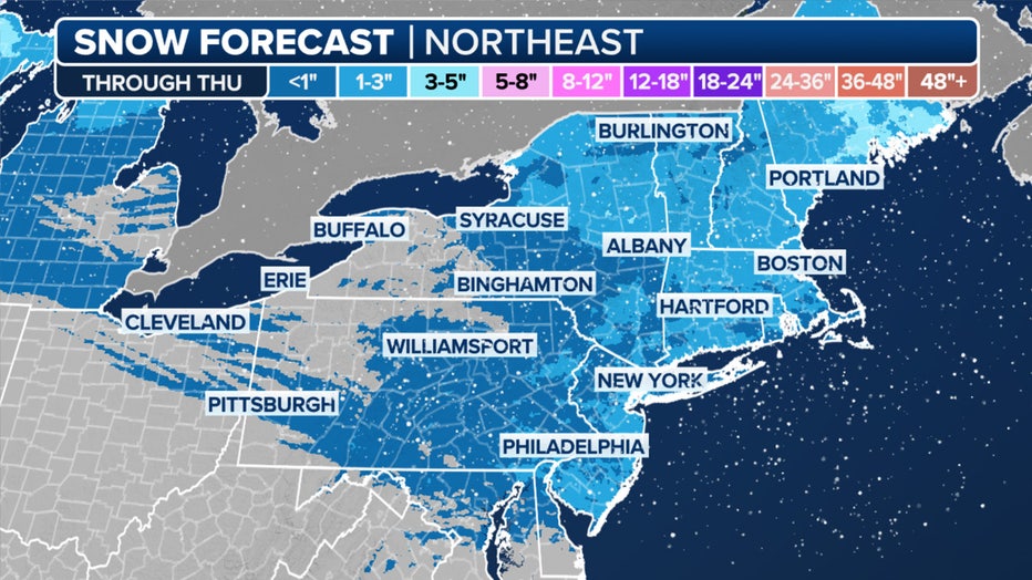
This graphic shows the forecast snow totals in the Northeast and New England through Thursday, Jan. 6, 2025. (FOX Weather)
But the FOX Forecast Center said that warm air would move in, changing the snow to either freezing rain or plain rain. Any snow left behind will nearly completely melt.
How much snow are we getting on Thursday?
By the numbers:
Snow and sleet accumulations of up to 2 inches are possible for most of the Tri-State area. While the totals may be low, it's expected to be a heavy wet snow compacted by sleet, resulting in an icy slush.
"Final amounts could go up or down depending on the strength/duration of the system and how long the colder air stays in place," the NWS said.
As for ice accretion, a glaze is possible across portions of NYC metro, western Long Island and coastal Connecticut. Up to one tenth is expected further inland.
What they're saying:
"Precipitation spanning from the Midwest to the northern Mid-Atlantic is anticipated to fall mostly as an icy mix of freezing rain and sleet later this afternoon, persisting through Thursday," the NOAA NWS Weather Prediction Center said in a post on Facebook.
What we don't know:
Exact precipitation types and expected amounts are still uncertain at the time, according to the NWS:
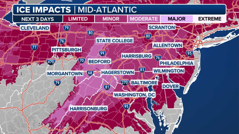
This graphic shows the possible ice imacts over the next three days. (FOX Weather)
- If colder air remains in place a bit longer, snow and/or ice amounts may be slightly higher.
- If warmer air is faster to move across the area, snow and ice amounts may be lower.
"This is still an uncertain forecast with further changes to forecast snow and ice amounts possible," the agency said. "Regardless, the main takeaway remains the same: wintry precipitation will lead to icy and slippery conditions Wednesday night – Thursday morning."
What you can do:
"Minor freezing rain accumulations on roadways makes for dangerous travel," the NOAA NWS Weather Prediction Center said in a post on Facebook. "Accumulating sleet can be strenuous to shovel and be treacherous to both drive and walk on. Be sure to check conditions before venturing out and drive slow."
Winter storm weather forecast: Weekend storm?
What's next:
The system will quickly exit by Thursday, leaving mainly dry conditions in its wake on Thursday night and Friday. However, another winter storm could impact many of these same areas over the weekend.
Featured

Multiple snow, ice threats for NYC in February, including this weekend
Just as one storm packing snow and ice exits the NYC area, another is on the way to parts of NY, NJ and CT this weekend -- and next week.
That storm will reach the Northeast on Saturday night and produce another round of snow, sleet and freezing rain.
- Saturday: A chance of rain and snow after 1 p.m. Mostly cloudy, with a high near 38. The chance of precipitation is 40%.
- Saturday night: Rain, possibly mixed with snow and freezing rain, becoming all rain after midnight. Low around 34. The chance of precipitation is 90%.
- Sunday: A 40% chance of rain before 1 p.m. Mostly cloudy, with a high near 44.
Snow storm NYC next week
Right now, the NWS is predicting a 40% chance of snow on Tuesday, as well. Skies will be mostly cloudy, with a high near 36.
FOX Weather LIVE updates
NYC weather radar
Click HERE for more information.